|
FA2000.51:-
|
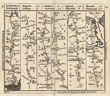
Strip map, uncoloured engraving, road map from a road book, Bowles's Post
Chaise Companion, by Carington Bowles, St Paul's Churchyard, London, 1782.
|
|
Vol.1 p.57/58 - the road from London to Portsmouth, from London; through
Kingston, Guildford and Godalming, Surrey; to Liphook, Hampshire; across a
corner of West Sussex; then Petersfield, Horndean, Cosham, to Portsmouth,
Hampshire.
|
|
map feature:-
|
not coloured & title cartouche & north point & coast form lines
& rivers & relief & hill hachuring & woods & trees &
parks & county & settlements & roads & road distances &
distances from London & streets & fortifications & water mills |
|
dimension:- |
wxh = 17x16cm |
|
wxh = 163x140mm |
|
wxh, map = 153x136mm |
|
scale = 1 to 180000 ? (estimated from marked miles as 1 to 178533 assuming
modern mile) |
 |
|
|
reference:- |
Bowles, Carington: 1782: Post Chaise Companion: (London) |

|
Map Group -- Bowles 1782 -- with Research Notes
|
|
|
|
town names:-
|
|
Hamp Shire
|
Hampshire
|
|
map name
|
modern name
|
|
Petersfield
|
Petersfield
|
|
Portsmouth
|
Portsmouth
|
|
|
|

| top of page |
| MN: 4.10.2001 |