|
FA2000.60:-
|
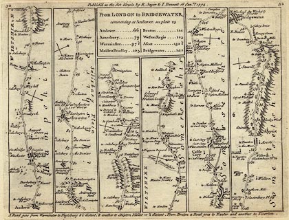
Strip map, road map, uncoloured engraving, The Road from London to
Bridgewater, scale about 1.5 miles to 1 inch, from road book, Jefferys's
Itinerary, by Thomas Jefferys, published by R Sayer and T Bennet, London
1775.
|
|
Pl.32 Andover, Hampshire to Wiltshire border; through Amesbury, Shrewton,
Warminster and Maiden Bradley, Wiltshire; then Wincanton and Bruton, to
Bridgewater, Somerset.
|
|
map feature:-
|
not coloured & title cartouche (plain box, sides straight, the map 'scrolls'
are rectangular boxes) & north point & road distances & table of
distances & roads & settlements & streets & rivers &
windmills & woods & relief & hillocks & county |
|
inscription:- |
printed -on- title cartouche
From LONDON to BRIDGEWATER, / commencing at Andover, see plate 25 / ....
-- title and table of distances |
|
inscription:- |
printed -on- upper centre
Publish'd as the Act directs by R. Sayer & T. Bennet 16 Janry. 1775.
|
|
dimension:- |
wxh, sheet = 23.5x19.5cm |
|
wxh, plate = 215x164mm |
|
wxh, map = 208x155mm |
|
scale = 1 to 84000 ? (rough estimate) |
 |
|

|
Map Group -- Jefferys 1775 -- with Research Notes
|
 |
|
|
town names:-
|
|
Hampshir
|
Hampshire
|
|
map name
|
modern name
|
|
Andover
|
Andover
|
|
 |
|

| top of page |
| MN: 8.2.2004 |


