|
FA2000.61:-
|
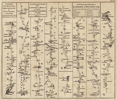
Strip map, road map, uncoloured engraving, roads or parts of roads from
Shrewsbury to Welshpool, London to Wells and St Edmunds Bury, and London to
Weymouth, scale about 2 miles to 1 inch, published in the Universal Magazine of
Knowledge and Pleasure, by John Hinton, Kings Arms, St Paul's Churchyard,
London, 1765-73.
|
|
Pl.21 Shrewsbury to Welshpool - from Shrewsbury, Shropshire; to Welshpool,
Powys.
|
|
Pl.21 London to Wells and St Edmunds - from Newmarket, Cambridgeshire; across a
corner of Suffolk; to Swaffham and Wells, Norfolk; AND from Newmarket,
Cambridgeshire; to Bury St Edmunds, Suffolk.
|
|
Pl.21 London to Weymouth - from Basingstoke, to Sutton Scotney and Stockbridge,
Hampshire; then Downton, Wiltshire; to Cranborne, Blandford and Dorchester, then
Weymouth, Dorset.
|
|
map feature:-
|
not coloured & title cartouche & plain cartouche & north point &
coast form lines & rivers & relief & hillocks & woods &
county & settlements & roads & road distances & distances from
London & wells (sweep wells) & mills & windmills |
|
inscription:- |
printed -on- title cartouche
Continuation / of the ROAD from / SHREWSBURY / to / WELSHPOOL, / in North
Wales / Commencg. at Shrewsbury in Pl.20
|
|
inscription:- |
printed -on- title cartouche
A SURVEY of the ROADS / from / LONDON to WELLS / in Norfolk, / and ST.
EDMUNDS BURY / in Suffolk / Both Commencing at Newmarket in / Plate 18.
|
|
inscription:- |
printed -on- title cartouche
A SURVEY of the ROAD from / LONDON to WEYMOUTH / Commencing at Basingstoke
in Pl.10 & from thence to / ....
-- with table of distances |
|
dimension:- |
wxh, sheet = 40x32cm |
|
wxh, map = 350x296mm |
|
scale = 1 to 140000 ? (guess) |
 |
|

|
Map Group -- Hinton 1765 -- with Research Notes
|
 |
|
|
town names:-
|
|
Hampshire
|
Hampshire
|
|
map name
|
modern name
|
|
Stockbridge
|
Stockbridge
|
|
 |
|

| top of page |
| MN: 4.10.2001 |


