|
FA2001.5:-
|
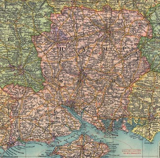
Map, colour printed, South East and Central England, scale about 1 to 320000,
about 5 miles to 1 inch, by G W Bacon, published by Frank Richardson Ltd,
Deansgate, Manchester, about 1912.
|
|
The map is sectioned for folding, mounted, and folded in board covers.
|
|
The map covers Derbyshire, Nottinghamshire, Lincolnshire, Leicestershire,
Rutland, Warwickshire, Northamptonshire, Huntingdon, Cambridgeshire, Norfolk,
Suffolk, Bedfordshire, Oxfordshire, Buckinghamshire, Hertfordshire, Essex,
Middlesex, London, Berkshire, Wiltshire, Hampshire, Surrey, East and West
Sussex, and Kent.
|
|
As well as the map there is an index gazetteer of towns, an insert geological
map, list of populations and areas of counties, triangular table of distances
between towns, and a table of the speed limits for motors imposed in certain
towns.
|
|
map feature:-
|
mounted & sectioned for folding & folded & card cover & up is N
& scale line & table of symbols & gazetteer (of towns) & index
grid & table of data (population, areas, speed limits) & inset map
(geology) & sea tinted & rivers & relief & hill hachuring &
woods (some) & parks & county & settlements & roads & road
distances & railways & canals |
|
inscription:- |
printed -on- cover
RICHARDSON'S / MAP OF / SOUTH EAST / AND / CENTRAL ENGLAND.
|
|
inscription:- |
printed -on- upper left
RICHARDSON'S / SOUTH EAST & CENTRAL ENGLAND / A MAP COMPRISING THE COUNTIES
OF - DERBY NOTTINGHAM / LINCOLN LEICESTER RUTLAND WARWICK NORTHAMPTON /
HUNTINGDON CAMBRIDGE NORFOLK SUFFOLK BEDFORD OXFORD / BUCKINGHAM HERTFORD ESSEX
MIDDLESEX LONDON / BERKSHIRE WILTSHIRE HAMPSHIRE SURREY SUSSEX & KENT / SHOWING
BOROUGHS IN SEPARATE COLOURS, RAILWAYS, ROADS, & GOLF LINKS
|
|
inscription:- |
printed -on- bottom left
-- COPYRIGHT ... G. W. BACON |
|
inscription:- |
printed -on- bottom
PUBLISHED BY / FRANK RICHARDSON, LIMITED / DEANSGATE, MANCHESTER
|
|
scale line:-
|
25 miles = 127.2 mm |
|
dimension:- |
wxh, booklet, map folded = 21x33cm |
|
wxh, sheet, opened = 94.5x124.5cm |
|
scale = 1 to 320000 ? (1 to 316302 from scale line) |
 |
|

|
Map Group -- Richardson 1912
|
 |
|
|
town names:-
|
|
Hampshire
|
Hampshire
|
|
map name
|
modern name
|
|
Alton
|
Alton
|
|
Andover
|
Andover
|
|
Basingstoke
|
Basingstoke
|
|
Bishops Waltham
|
Bishops Waltham
|
|
Christchurch
|
Christchurch
|
|
Fareham
|
Fareham
|
|
Fordingbridge
|
Fordingbridge
|
|
Gosport
|
Gosport
|
|
Havant
|
Havant
|
|
Kingsclere
|
Kingsclere
|
|
Lymington
|
Lymington
|
|
New Alresford
|
Alresford
|
|
Odiham
|
Odiham
|
|
Petersfield
|
Petersfield
|
|
Portsmouth
|
Portsmouth
|
|
Ringwood
|
Ringwood
|
|
Romsey
|
Romsey
|
|
Southampton
|
Southampton
|
|
Stockbridge
|
Stockbridge
|
|
Whitchurch
|
Whitchurch
|
|
Winchester
|
Winchester
|
|
 |
|

| top of page |
| MN: 4.10.2001 |


