|
FA2001.46.16:-
|
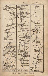
Strip map, uncoloured engraving road maps, London to Lymington, to Gosport,
to Salisbury etc, scale about 9 miles to 1 inch, in Smith's New Pocket
Companion, engraved by Pickett, published by Charles Smith and Son, 172 Strand,
London, 1827.
|
|
The sheet includes 'pages' 16, 17, 18.
|
|
p.16 - London to Lymington and Yarmouth, Isle of Wight; from Southampton through
Lyndhurst to Lymington, Hampshire; or by the Hythe Ferry through Beaulieu to
Lymington; and by ferry to Yarmouth, Isle of Wight.
|
|
Links - London to Southampton see p.14, Isle of Wight see p.127.
|
|
p.16 - London to Gosport; from Alton through Filmer Hill, Wickham, Fareham to
Gosport, Hampshire.
|
|
Links - London to Alton see p.14.
|
|
pp.17,18 - London to Salisbury, Dorchester, Exeter, Falmouth and Lands End; from
London; through Brentford and Staines, Middlesex; then Egham, Bagshot, Surrey;
through Blackwater, Hartford Bridge, Basingstoke, Whitchurch, Andover,
Hampshire; side road to Odiham, Hampshire; then Lopcomb Corner, Salisbury and
beyond, Wiltshire.
|
|
Continued on pp.19-22 etc.
|
|
Links - to Farnham see p.14.
|
|
map feature:-
|
not coloured & north point & coast form lines & rivers (minimal)
& relief & hill hachuring (some) & parks & county &
settlements & roads & distances from London |
|
dimension:- |
wxh, sheet = 11.5x17.5cm |
|
wxh, map = 96x155mm |
|
scale = 1 to 570000 ? (crude estimate) |
 |
|

|
Map Group -- Smith 1826 -- with Research Notes
|
 |
|

| top of page |
| MN: 25.2.2002 |


