|
FA2001.94:-
|
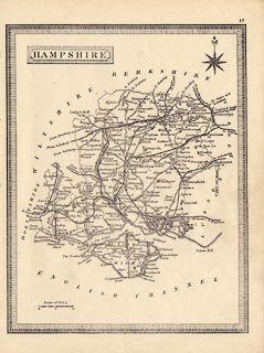
Map, uncoloured engraving, Hampshire, with Isle of Wight, scale about 1 to
750000, about 12 miles to 1 inch, published about 1862?
|
|
It has been suggested that is by Haywood, published in Harrison's School Atlas,
1878-91. The railways suggest otherwise.
|
|
map feature:-
|
not coloured & title cartouche & plain cartouche & compass rose
& up is N & scale line & coast form lines & rivers & parks
& county & settlements & roads & railways & canals |
|
inscription:- |
printed -on- title cartouche
HAMPSHIRE
|
|
scale line:-
|
10 miles = 21.4 mm |
|
dimension:- |
wxh, sheet = 17x23cm |
|
wxh, map = 151x194mm |
|
scale = 1 to 750000 ? (1 to 750030 from scale line assuming modern mile) |
 |
|

|
Map Group -- Unknown 1860s -- with Research Notes
|
 |
|

| top of page |
| MN: 4.10.2001 |


