|
FA2001.97:-
|
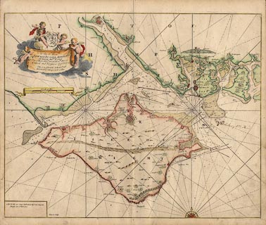
Chart, hand coloured engraving, map of The Solent, including the coast of
Hampshire and the Isle of Wight, scale about 1 to 100000, about 1 1/2 miles to 1
inch, by Captain Greenvile Collins, engraved by J Harris, published in Great
Britain's Coasting Pilot, 1693-1753
|
|
map feature:-
|
dedication & coat of arms & compass rose & rhumb lines & up is N
& scale line & coast shaded & coast appearance & harbours &
depth soundings & foreshore & sandbanks & leading lines &
anchorages & castles & sea marks & rivers & ferries &
bridges & hillocks & beacons & salterns & settlements &
fortifications & mills & windmills |
|
inscription:- |
printed -on- drape cartouche, upper left
To the Rt. Honble. / EDWARD RUSSELL ADMIRALL / OF THEIR MATIES. FLEET / One
of their Maties. most Honble. Privy / Council and Treasurere of ye Navy &c /
This is most humbly dedicated and / presented by Capt. Greenvile Collins.
-- dedication |
|
scale line:-
|
6 nautical miles = 106.9 mm |
|
dimension:- |
wxh, sheet = 60x51cm |
|
wxh, plate = 579x462mm |
|
wxh, map = 570x455mm |
|
scale = 1 to 100000 ? (1 to 104065 from scale line assuming a sea mile) |
 |
|

|
Map Group -- Collins 1693 -- with Research Notes
|
 |
|
|
town names:-
|
|
Hampshire
|
Hampshire
|
|
map name
|
modern name
|
|
Fareham
|
Fareham
|
|
Gosport
|
Gosport
|
|
Limington
|
Lymington
|
|
Portsmouth
|
Portsmouth
|
|
Southampton
|
Southampton
|
|
 |
|

| top of page |
| MN: 4.10.2001 |


