|
FA2001.139:-
|
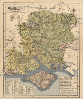
Map, colour printed, Hampshire, with the Isle of Wight, scale about 1 to
270000, about 4 miles to 1 inch, published by Letts, Son and Co, London Bridge,
London, about 1884?
|
|
map feature:-
|
colour printed & compass rose & scale line & table of symbols &
sea tinted & coast shaded (and tinted) & coastal defence & castles
& fortifications & rivers & relief & hill hachuring & woods
& forests (and list of areas) & parks & county & hundreds &
table of hundreds & electoral data (and list) & settlements & roads
& railways & canals |
|
inscription:- |
printed -on- title cartouche
HAMPSHIRE / AND ISLE OF WIGHT
|
|
inscription:- |
printed -on- bottom
LETTS, SON & Co LIMITED LONDON BRIDGE E C
|
|
scale line:-
|
12+1 miles = 77.6 mm |
|
dimension:- |
wxh, sheet = 35.5x42.5cm |
|
wxh, map = 326x404mm |
|
scale = 1 to 270000 ? (1 to 269607 from scale line assuming modern mile) |
|
longitude, Winchester = 1d 18.2m W (approx) |
 |
|

|
Map Group -- Letts 1884 -- with Research Notes
|
 |
|

| top of page |
| MN: 24.10.2001 |


