|
FA2002.23:-
|
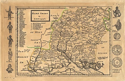
Map, uncoloured engraving, Hamp Shire ie Hampshire, scale about 6.5 miles to
1 inch, by Herman Moll, included in a New Description of England, published
1724.
|
|
This copy has engravings of antiquities printed in a column down each side of
the page, outside the map; these pictures include figures of Mercuris, Bacchus,
Pallas and Virgo Vestalis, and a coin of Emperor Alaxeander Augustus, and a
saxon coin of Edgar minted at Winchester.
|
|
map feature:-
|
not coloured & title cartouche & scale line & up is N & lat and
long scales & table of hundreds & sandbanks & coast shaded &
coastal defence & castles & rivers & relief & hillocks &
forests & parks & county & hundreds & settlements &
roads |
|
inscription:- |
printed -on- title cartouche
HAMP SHIRE / By / H. Moll Geographer.
|
|
scale line:-
|
6 miles = 26.4 mm |
|
dimension:- |
wxh, sheet = 36x23.5cm |
|
wxh, plate = 317x195mm |
|
wxh, map = 259x188mm |
|
scale = 1 to 370000 ? (1 to 365760 from scale line assuming a statute mile) |
 |
|

|
Map Group -- Moll 1724 -- with Research Notes
|
 |
|

| top of page |
| MN: 22.10.2002 |


