|
FA2002.28:-
|
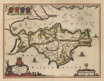
Map, hand coloured engraving, Vectis Insula or the Isle of Wight, scale about
1.5 miles to 1 inch, published in Theatrum Orbis Terrarum, by William J Blaeu,
Amsterdam, Netherlands, 1645.
|
|
map feature:-
|
title cartouche & scroll cartouche & labelled borders & up is N
& scale line & coat of arms & coast shaded & ships &
sandbanks & coastal defence & castles & rivers & relief &
hillocks & beacons & mills & windmills & bridges & forests
& woods & parks & county & settlements |
|
inscription:- |
printed -on- title cartouche
VECTIS / INSULA / Anglice / THE ISLE OF / WIGHT
|
|
inscription:- |
printed -on- lower, right of centre
Ioh. Blaeu Excud.
|
|
inscription:- |
printed -on- below scale line
Quatuor Milliaria Anglica sive / unum milliare Germanicum
|
|
scale line:-
|
4 miles = 76.1 mm |
|
dimension:- |
wxh, sheet = 60x49cm |
|
wxh, plate = 514x391mm |
|
wxh, map = 509x387mm |
|
scale = 1 to 85000 ? (1 to 84591 from scale line wrongly assuming statute
mile) |
 |
|

|
Map Group -- Blaeu 1645 -- with Research Notes
|
 |
|

| top of page |
| MN: 10.11.2002 |


