|
B2002.76.7:-
|
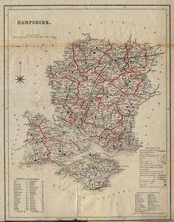
Map, uncoloured engraving, Hampshire with the Isle of Wight, scale about 4.5
miles to 1 inch, in the 20th edition of Robson's Commercial Directory of the
Seven Counties ..., published by William Robson and Co, London Directory and
Court Guide Office, 4 Cloak Lane, Cheapside, London, 1839.
|
|
inscription:- |
printed -on- upper left
HAMPSHIRE
|
|
inscription:- |
printed -on- bottom
William Robson and Co. Drectory Office London
|
|
map feature:-
|
not coloured & compass rose & scale line & lat and long scales &
table of symbols & coast shaded & coastal defence & castles &
rivers & relief & hill hachuring & woods & forests & parks
& county & hundreds & table of hundreds & parish unions &
settlements & roads & turnpike roads & post roads & distances
from London & road distances & railways & canals & electoral
data |
|
scale line:-
|
15 miles = 84.1 mm |
|
dimension:- |
wxh, sheet = 38x48cm |
|
wxh, map = 454x352mm |
|
scale = 1 to 290000 ? (1 to 287041 estimated from scale line) |
|
longitude, Winchester = 1d 18.5m W (approx) |
 |
|

|
Map Group -- Robson 1839 -- with Research Notes
|
 |
|

| top of page |
| MN: 11.6.2002 |


