|
FA2002.84.2:-
|
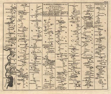
Road map, strip map, uncoloured engraving, Road from London to the 204th Mile
Stone ... Lands End, scale about 2.5 miles to 1 inch, plate 10, published by
John Hinton in the Universal Magazine of Knowledge and Pleasure, London,
1767.
|
|
plate 10; from London; through Brentford, and Staines, Middlesex; then Bagshot,
Surrey; Blackwater, Basingstoke, Whitchurch, Andover, and Middle Wallop,
Hampshire; Salisbury, Wiltshire; Shaftesbury, Sherborn, Dorset; Yeovil,
Somerset; Axminster, Honiton, Exeter, and beyond Ashburton, Devon.
|
|
map feature:-
|
not coloured & title cartouche & plain cartouche & north point &
rivers & relief & hillocks & parks & county & settlements
& roads & distances from London & mills & windmills |
|
inscription:- |
printed -on- title cartouche
The ROAD from LONDON to the 204th. / Mile Stone in the Way to / the
LANDS-END in / CORNWALL: / Measured from Cornhill to / ...
|
|
dimension:- |
wxh, sheet = 39.5x33cm |
|
wxh, plate = 368x313mm |
|
wxh, map = 355x299mm |
|
scale = 1 to 160000 ? (rough estimate from mile marks on road) |
 |
|

|
Map Group -- Hinton 1765 -- with Research Notes
|
 |
|
|
town names:-
|
|
Hampshire
|
Hampshire
|
|
map name
|
modern name
|
|
Basingstoke
|
Basingstoke
|
|
Whitchurch
|
Whitchurch
|
|
Andover
|
Andover
|
|
 |
|

| top of page |
| MN: 10.10.2002 |


