|
FA2002.85.2:-
|
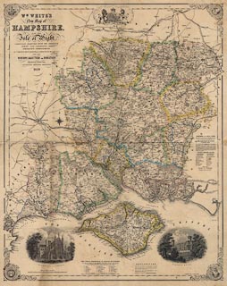
Map, New Map of Hampshire, with the Isle of Wight, scale about 3 miles to 1
inch, by P Brannon, engraved by Brannon and Co, published by William White,
Collegiate Crescent, Sheffield, West Yorkshire, 1859.
|
|
map feature:-
|
decorative spandrels & vignettes & coat of arms & up is N &
scale line & lat and long scales & table of symbols & table of data
(electoral etc) & coast form lines & coastal defence & castles &
fortifications & rivers & relief & hill hachuring & woods &
forests & parks & county & electoral data & settlements &
roads & railways & canals |
|
inscription:- |
printed -on- title, upper left
WM. WHITE'S / New Map of / HAMPSHIRE, AND THE / Isle of Wight, CAREFULLY
REDUCED FROM THE ORDNANCE / SURVEY AND COMPRISING ALL / SUBSEQUENT IMPROVEMENTS.
/ BY P. BRANNON, ARCHT. SURVEYOR, &c. & ENGRAVED BY BRANNON & Co. / FOR THE /
HISTORY, GAZETTEER AND DIRECTORY, / Published by William White, / COLLEGIATE
CRESCENT, SHEFFIELD, / 1859.
|
|
scale line:-
|
9+1 miles = 82.1 mm |
|
dimension:- |
wxh, sheet = 50x62.5cm |
|
wxh, map = 464x583mm |
|
scale = 1 to 200000 ? (1 to 196022 from scale line assuming statute mile) |
|
scale = 1 to 190000 ? (from town positions using DISTAB.exe) |
 |
|

|
Map Group -- Brannon 1859 -- with Research Notes
|
 |
|
|
town names:-
|
|
Hampshire
|
Hampshire
|
|
map name
|
modern name
|
|
Alton
|
Alton
|
|
Andover
|
Andover
|
|
Basingstoke
|
Basingstoke
|
|
Bishops Waltham
|
Bishops Waltham
|
|
Christ Church
|
Christchurch
|
|
Fareham
|
Fareham
|
|
Fordingbridg
|
Fordingbridge
|
|
Gosport
|
Gosport
|
|
Havant
|
Havant
|
|
Kingsclere
|
Kingsclere
|
|
Lymington
|
Lymington
|
|
Alresford
|
Alresford
|
|
Odiham
|
Odiham
|
|
Petersfield
|
Petersfield
|
|
Portsmouth
|
Portsmouth
|
|
Ringwood
|
Ringwood
|
|
Romsey
|
Romsey
|
|
Southampton
|
Southampton
|
|
Stockbridge
|
Stockbridge
|
|
Whitchurch
|
Whitchurch
|
|
Winchester
|
Winchester
|
|
 |
|

| top of page |
| MN: 27.8.2002 |


