|
FA2002.85.3:-
|
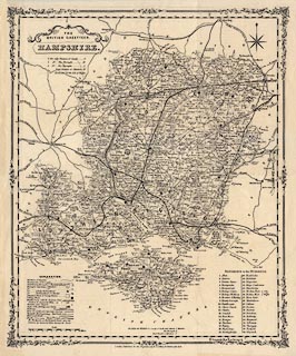
Map, uncoloured lithograph from an engraving, Hampshire, with the Isle of
Wight, scale about 4 miles to 1 inch, by Henry G Collins, 1850, published by
John Heywood, Manchester, 1868?
|
|
map feature:-
|
not coloured & decorative spandrels & title cartouche & scroll
cartouche (sort of) & compass rose & up is N & scale line & lat
and long scales & table of symbols & table of data & electoral data
& table of hundreds & coastal defence & castles & fortifications
& rivers & relief & hill hachuring & forests & parks &
county & hundreds & settlements & roads & railways &
canals |
|
inscription:- |
printed -on- title cartouche
THE BRITISH GAZETTEER / HAMPSHIRE.
|
|
inscription:- |
printed -on- bottom
London, Published for the Proprietors by H. G. Collins, 22 Paternoster
Row.
|
|
scale line:-
|
10+1 miles = 64.2 mm |
|
dimension:- |
wxh, sheet = 38.5x46cm |
|
wxh, map = 343x419mm |
|
scale = 1 to 280000 ? (1 to 275744 from scale line assuming statute mile) |
 |
|

|
Map Group -- Collins 1850 -- with Research Notes
|
 |
|
|
town names:-
|
|
Hampshire
|
Hampshire
|
|
map name
|
modern name
|
|
Alton
|
Alton
|
|
Andover
|
Andover
|
|
Basingstoke
|
Basingstoke
|
|
Bishops Waltham
|
Bishops Waltham
|
|
Christ Church
|
Christchurch
|
|
Fareham
|
Fareham
|
|
Fordingbridg
|
Fordingbridge
|
|
Gosport
|
Gosport
|
|
Havant
|
Havant
|
|
Kingsclere
|
Kingsclere
|
|
Lymington
|
Lymington
|
|
Alresford
|
Alresford
|
|
Odiham
|
Odiham
|
|
Petersfield
|
Petersfield
|
|
Portsmouth
|
Portsmouth
|
|
Ringwood
|
Ringwood
|
|
Romsey
|
Romsey
|
|
Southampton
|
Southampton
|
|
Stockbridge
|
Stockbridge
|
|
Whitchurch
|
Whitchurch
|
|
Winchester
|
Winchester
|
|
 |
|

| top of page |
| MN: 1.9.2002 |


