|
FA2002.501:-
|
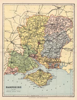
Map, colour lithograph? Hampshire with the Isle of Wight, scale about 6.5
miles to 1 inch, by F S Weller, published by William MacKenzie, London, etc,
about 1893?
|
|
The map shows the join from Chesil Station, Winchester, south to the London and
Southampton Railway, opened 1891; but does not show the Basingstoke to Alton
Light Railway or Meon Valley Line, opened in the 1900s.
|
|
map feature:-
|
scale line & lat and long scales (rectangular projection) & table of
symbols & sea tinted & rivers & relief & hill hachuring &
woods & forests & parks & county & electoral data (areas) &
settlements & roads & canals & railways & shipping routes |
|
inscription:- |
printed -on- title
HAMPSHIRE
|
|
inscription:- |
printed -on- bottom
F. S. Weller, F.R.G.S. / WILLIAM MACKENZIE, LONDON, EDINBURGH & GLASGOW.
|
|
scale line:-
|
10 miles = 39.0 mm |
|
dimension:- |
wxh, sheet = 26x32.5 |
|
wxh, map = 215x279mm |
|
scale = 1 to 410000 ? (1 to 412652 from scale line assuming statute mile) |
 |
|

|
Map Group -- MacKenzie 1893 -- with Research Notes
|
 |
|
|
town names:-
|
|
Hampshire
|
Hampshire
|
|
map name
|
modern name
|
|
Alton
|
Alton
|
|
Andover
|
Andover
|
|
Basingstoke
|
Basingstoke
|
|
Bishops Waltham
|
Bishops Waltham
|
|
Christchurch
|
Christchurch
|
|
Fareham
|
Fareham
|
|
Fordingbridg
|
Fordingbridge
|
|
Gosport
|
Gosport
|
|
Havant
|
Havant
|
|
Kingsclere
|
Kingsclere
|
|
Lymington
|
Lymington
|
|
New Alresford
|
Alresford
|
|
Odiham
|
Odiham
|
|
Petersfield
|
Petersfield
|
|
Portsmouth
|
Portsmouth
|
|
Ringwood
|
Ringwood
|
|
Romsey
|
Romsey
|
|
Southampton
|
Southampton
|
|
Stockbridge
|
Stockbridge
|
|
Whitchurch
|
Whitchurch
|
|
Winchester
|
Winchester
|
|
 |
|

| top of page |
| MN: 10.10.2002 |


