|
FA2002.504:-
|
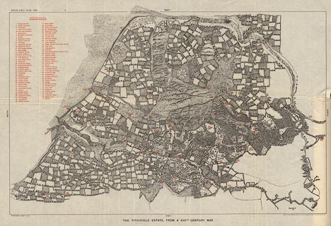
Map, lithograph, Titchfield Estate from a 17th Century Map, drawn by
Wilberforce Cobbett, lithographed by Sprague and Co, 4-5 East Harding Street,
Fetter Lane, London, 1906.
|
|
Inserted in the Proceedings of the Hampshire Field Club, vol.5, 1906. Printed
b&w with red overprinted numbers keying places to a table.
|
|
map feature:-
|
up is W & compass rose |
|
inscription:- |
printed -on- bottom
THE TITCHFIELD ESTATE FROM A XVIITH. CENTURY MAP
|
|
inscription:- |
printed -on- bottom left/right
WILBERFORCE COBBETT DELT. / PHOTO-LITHO. SPRAGUE & Co. 4&5 EAST HARDING
STREET, FETTER LANE, E.C.
|
|
dimension:- |
wxh, sheet = 56x38cm |
|
wxh, map = 515x330mm |
 |
|
|
reference:- |
: 1906:: ProcHFC: vol.5: opp p.203 |

|
Map Group -- Titchfield 1600s
|
 |
|

| top of page |
| MN: 10.10.2002 |


