|
FA2002.505:-
|
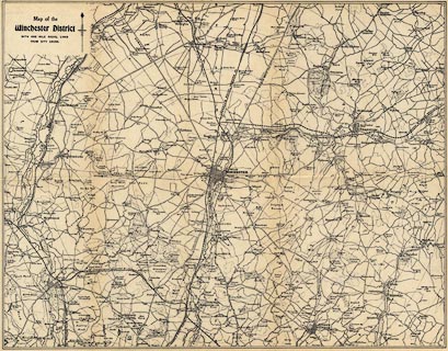
Map, uncoloured engraving, Map of the Winchester District, Hampshire, scale
about 1.5 miles to 1 inch, published in Warren's Guide to Winchester, by Warren
and Son, Winchester, Hampshire, 1890s-1920s?
|
|
The map includes about 10 miles radius around Winchester.
|
|
The map was certainly inserted in the 1928 edition of the guide, which was first
published 1836; the railways do not include the join from Chesil Station to
Compton Junction which opened 1891.
|
|
map feature:-
|
not coloured & north point & up is N & scale circles & rivers
& parks & settlements & roads & railways |
|
inscription:- |
printed -on- upper left
Map of the / Winchester District / WITH ONE MILE RADIUS LINES / FROM CITY
CROSS
|
|
scale line:-
|
20 miles = 377.8 mm |
|
dimension:- |
wxh, sheet = 41.5x32cm |
|
wxh, map = 399x312mm |
|
scale = 1 to 85000 ? (1 to 85196 from scale circles assuming modern mile) |
 |
|

|
Map Group -- Warren 1890s
|
 |
|

| top of page |
| MN: 1.9.2002 |


