|
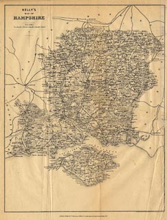
B2002.86.1:-
|
Map, uncoloured engraving, Kelly's Map of Hampshire, scale about 4 miles to 1
inch, by Kelly and Co, 51 Great Queen Street, Lincoln's Inn Fields, London,
1889.
|
|
map feature:-
|
not coloured & north point & up is N & scale line & sea plain
& coast form lines & coastal defence & castles & rivers &
woods & forests & parks & county & settlements & roads &
railways |
|
inscription:- |
printed -on- title, upper left
KELLY'S / MAP OF / HAMPSHIRE
|
|
inscription:- |
printed -on- bottom
Drawn & Engraved by Kelly & Co. 51, Great Queen Street W.C. / London - Kelly
& Co. Directory Offices, 51 Great Queen St. Lincoln's Inn Fields W.C.
|
|
scale line:-
|
10 miles = 58.9 mm |
|
dimension:- |
wxh, sheet = 35x43.5cm |
|
wxh, map = 309x398mm |
|
scale = 1 to 270000 ? (1 to 273233 from scale line) |
 |
|

|
Map Group -- Kelly 1889
|
 |
|

| top of page |
| MN: 1.10.2002 |


