|
FA2002.513:-
|
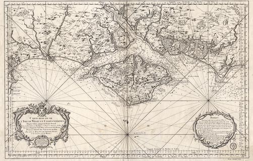
Chart, uncoloured engraving, Carte Reduite de l'Isle de Wight et Costes
Voisines, scale about 2 inches to 1 league, 2 statute miles to 1 inch, by
Jacques Bellin, engraved by Raineau? published at the Depot de la Marine, Paris,
France, 1762.
|
|
ie Chart of the Isle of Wight and Adjacent Coasts; the coasts of Dorset from
Peveral Point, Hampshire, and Sussex to beyond Selsey Bill. Although this is a
chart it shows inland topography.
|
|
map feature:-
|
not coloured & title cartouche & scroll cartouche & coat of arms
& compass rose & up is N & magnetic variation & rhumb lines
& lat and long scales (Paris and London meridians) & scale line &
sea plain & depth soundings & tides & sandbanks & buoys &
anchorages & coast appearance & harbours & rivers & relief &
hillocks & forests & trees & parks & settlements &
roads |
|
inscription:- |
printed -on- title cartouche, lower left
CARTE REDUITE DE / L'ISLE DE WIGHT ET COSTES VOISINES / Depuis Selsey
jusqu'a la Pointe Peverel / Avec les Portes Rades et Mouillages et le Detail de
l'interieur du Pais / Dressee au Depost des Cartes Plans et Journaux de la
Marine / POUR LE SERVICE DES VAISSEAUX DU ROY. / Par ordre de M. LE DUC DE
CHOISEUIL Ministre / de la Guerre et de la Marine. / Par le Sr. Bellin Ingr. /
de la Marine et du Depost / des Plans, Censeur Royal / de l'Academie de Marine,/
/ et de la Societe Royale de / Londres. / 1762.
|
|
inscription:- |
printed -on- bottom left
R[aineau] s.
-- very faint |
|
inscription:- |
printed -on- lower right
DEPOT DE LA MARINE
-- circle of rope, three fleur de lys, anchor |
|
scale line:-
|
11.5 leagues = 496.8 mm |
|
dimension:- |
wxh, sheet = 92.5x61cm |
|
wxh, plate = 912x593mm (apprx) |
|
wxh, map = 860x557mm |
|
scale = 1 to 130000 ? (1 to 128693 from scale line) |
 |
|

|
Map Group -- Bellin 1762 -- with Research Notes
|
 |
|

| top of page |
| MN: 13.12.2002 |


