|
FA1990.1:-
|
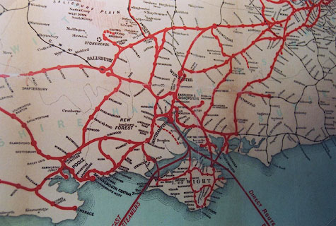
railway map, colour lithograph, Map of the London and South Western Railway,
southern England, scale about 5.5 miles to 1 inch, published by the LSWR,
printed by Waterlow and Sons, London Wall, London, 1905.
|
|
The map includes from London to Padstow, from Cheltenham to the English Channel.
|
|
map feature:-
|
table of symbols & up is N & sea tinted & coast form lines &
county & railways & settlements (if they have a station) & shipping
routes (LSWR) |
|
inscription:- |
printed -on- upper left
Map of the / LONDON & SOUTH WESTERN / RAILWAY.
|
|
inscription:- |
printed -on- lower right
WATERLOW & SONS LONDON WALL, LONDON. / 1905
|
|
dimension:- |
wxh, map = 948x646mm |
|
wxh = 127x91.5cm |
|
scale = 1 to 350000 ? (estimated from a couple of place positions) |
 |
|

|
Map Group -- LSWR 1905 -- with Research Notes
|
 |
|
|
town names:-
|
|
Hampshire
|
Hampshire
|
|
map name
|
modern name
|
|
Alton
|
Alton
|
|
Andover
|
Andover
|
|
Basingstoke
|
Basingstoke
|
|
Bishops Waltham
|
Bishops Waltham
|
|
Christchurch
|
Christchurch
|
|
Fareham
|
Fareham
|
|
Fordingbridg
|
Fordingbridge
|
|
Gosport
|
Gosport
|
|
Havant
|
Havant
|
|
Kingsclere
|
Kingsclere
|
|
Lymington
|
Lymington
|
|
Alresford
|
Alresford
|
|
Odiham
|
Odiham
|
|
Petersfield
|
Petersfield
|
|
Portsmouth
|
Portsmouth
|
|
Ringwood
|
Ringwood
|
|
Romsey
|
Romsey
|
|
Southampton
|
Southampton
|
|
Stockbridge
|
Stockbridge
|
|
Whitchurch
|
Whitchurch
|
|
Winchester
|
Winchester
|
|
 |
|

| top of page |
| MN: 31.3.2003 |


