|
FA2002.653:-
|
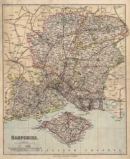
Map, colour lithograph, Hampshire, scale about 4 miles to 1 inch, published
by George Philip and Son, London and Liverpool, Lancashire, about 1857, edition
about 1900.
|
|
The map was probably first included in Philips' County Atlas of England and
Wales, 1857. The railways include the Lee-on-the-Solent Light Railway opened
1894, but not the Meon Valley line authorized 1897, opened 1903, nor the
Basingstoke and Alton Light Railway opened 1901. This suggests it is the edition
published about 1900.
|
|
map feature:-
|
up is N & scale line & lat and long scales & lat and long grid &
sea tinted & coast tinted & rivers & woods & forests &
relief & hill hachuring & parks & county & electoral data &
settlements & roads & railways & canals |
|
inscription:- |
printed -on- lower left
HAMPSHIRE
|
|
inscription:- |
printed -on- bottom
GEORGE PHILIP & SON, LONDON & LIVERPOOL.
|
|
scale line:-
|
8 miles = 52.1 mm |
|
dimension:- |
wxh, sheet = 36x44cm |
|
wxh, map = 338x413mm |
|
scale = 1 to 240000 ? (1 to 241716 from scale line) |
|
scale = 1 to 250000 ? (1 to 246603 from town positions using DISTTAB.exe) |
 |
|
|
reference:- |
: 1857: Philips' County Atlas of England and Wales: Philip, George and Son
(London) |
|
Smith, David: 1985: Victorian Maps of the British Isles: Batsford (London)::
ISBN 7134 4178 X |

|
Map Group -- Philip 1857-1900 -- with Research Notes
|
 |
|
|
town names:-
|
|
Hampshire
|
Hampshire
|
|
map name
|
modern name
|
|
Alton
|
Alton
|
|
Andover
|
Andover
|
|
Basingstoke
|
Basingstoke
|
|
Bishops Waltham
|
Bishops Waltham
|
|
Christchurch
|
Christchurch
|
|
Fareham
|
Fareham
|
|
Fordingbridg
|
Fordingbridge
|
|
Gosport
|
Gosport
|
|
Havant
|
Havant
|
|
Kingsclere
|
Kingsclere
|
|
Lymington
|
Lymington
|
|
Alresford
|
Alresford
|
|
Odiham
|
Odiham
|
|
Petersfield
|
Petersfield
|
|
Portsmouth
|
Portsmouth
|
|
Ringwood
|
Ringwood
|
|
Romsey
|
Romsey
|
|
Southampton
|
Southampton
|
|
Stockbridge
|
Stockbridge
|
|
Whitchurch
|
Whitchurch
|
|
Winchester
|
Winchester
|
|
 |
|

| top of page |
| MN: 9.7.2003 |


