|
FA2002.654:-
|
Atlas, Stanford's Geological Atlas of Great Britain and Ireland, by Horace B
Woodward, published by Edward Stanford, 12-14 Long Acre, London, 3rd edn
1914.
|
|
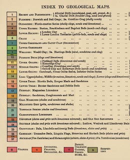
The book has - title page; preface by H B Woodward, Croydon, Surrey, 1913;
contents, list of sections, views, geological maps, plates of fossils; table of
strata and list of characteristic fossils; descriptions of geology of countries
and individual counties; descriptions of the geology seen on railway journeys;
list of fossils; index; 64 colour printed geological maps of Great Britain and
the counties (some maps are documented separately); plates of fossils.
|
|
The book has been rebound, amateurishly, and the map plates are trimmed a bit
tight.
|
|
inscription:- |
printed -on- title page
STANFORD'S / GEOLOGICAL ATLAS / OF GREAT BRITAIN / AND IRELAND / WITH PLATES
OF CHARACTERISTIC FOSSILS / PRECEDED BY DESCRIPTIONS OF THE GEOLOGICAL /
STRUCTURE OF GREAT BRITAIN AND IRELAND / AND THEIR COUNTIES; OF THE CHANNEL /
ISLANDS; AND OF THE FEATURES / OBSERVABLE ALONG THE / PRINCIPAL LINES OF /
RAILWAY / BY HORACE B. WOODWARD, F.R.S., F.G.S. / THIRD EDITION / LONDON: EDWARD
STANFORD, LTD. / 12, 13, & 14, LONG ACRE, W.C. / 1914
|
|
dimension:- |
wxh = 14x20cm |
 |
|

|
Map Group -- Stanford 1904 -- with Research Notes
|
 |
|

| top of page |
| MN: 9.7.2003 |


