|
FA1992.1.1:-
|
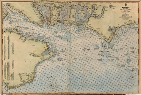
Chart, hand coloured engraving, England South Coast, Owers to Dunnose
including Spithead, scale about 1.2 miles to 1 inch, surveyed by Captain William
L Sheringham RN, published by the Hydrographic Office, 1848.
|
|
One coastal view is relevant to Hampshire - Portsea Island from the south 'Dock
Mill in one with W. end of Chalk Pit N. by E. 1/2 E. is the mark for the
Bembridge Buoyand clears Betty Ledge.'
|
|
map feature:-
|
compass rose & magnetic variation & lat and long scales & lat and
long grid & sea tinted & depth soundings & depth contours &
sandbanks & sea marks & leading lines & lighthouses & buoys
& coast line tinted & coast view & harbours & headlands &
coastal defence & castles & fortifications & settlements & roads
& railways & telegraphs & mills & windmills |
|
inscription:- |
printed -on- upper right
HYDROGRAPHIC OFFICE
-- foul anchor & wreath of oak leaves |
|
inscription:- |
printed -on- upper right
ENGLAND / SOUTH COAST / OWERS TO DUNNOSE / INCLUDING / SPITHEAD / SURVEYED
BY CAPTN. SHERINGHAM R.N. F.G.&A.S.
|
|
dimension:- |
wxh, sheet = 96.5x65cm (trimmed at bottom) |
|
wxh, map = 947x640mm (?) |
|
scale = 1 to 53000 ? (1 to 52558 from latitude scale, 15 mins = 529.5 mm) |
 |
|

|
Map Group -- Sheringham 1840s-50s -- with Research Notes
|
 |
|
|
town names:-
|
|
Hampshire
|
Hampshire
|
|
map name
|
modern name
|
|
Fareham
|
Fareham
|
|
Gosport
|
Gosport
|
|
Havant
|
Havant
|
|
Portsmouth
|
Portsmouth
|
|
 |
|

| top of page |
| MN: 27.6.2004 |


