|
FA2004.1:-
|
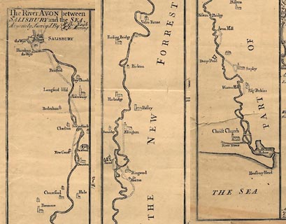
Map, uncoloured engraving, The City of Salisbury, scale about 20 ins to 1
mile, by William Naish, first published 1716, 3rd edition published by Benjamin
Collins, New Canal, Salisbury, Wiltshire, 1751, with an inset map of the River
Avon from Salisbury to the Sea, scale about 1 inch to 1 mile, through Wiltshire,
Hampshire and Dorset, surveyed by Thomas Naish and James Mooring, 1675.
|
|
map feature:-
|
not coloured & sea plain & coast shaded & rivers &
settlements |
|
inscription:- |
printed -on- title cartouche
The / City of SALISBURY wth. the / Adjacent CLOSE, CHURCH and / RIVER
Accurately Surveyed By / William Naish. / ... / Sarum. Printed & Sold by Benjn.
Collins, / Printer, on the New Canal.
|
|
inscription:- |
printed -on- dedication cartouche
To the Right Reverend Father / in God JOHN Lord BISHOP of / SARUM; / This
Plate is humbly dedicated by his / Lordship's most obedient humble Servant /
Benjn. Collins.
|
|
inscription:- |
printed -on- title cartouche of inset map
The RIVER AVON between / SALISBURY and the SEA. / Accuratley Survey'd by Mr.
Tho: Naish / Mr. Ja: Mooring
|
|
scale line:-
|
264 yards = 76.9 mm |
|
scale line:-
|
4 miles = 83.1 mm |
|
dimension:- |
wxh, sheet = 58.5x64.5cm |
|
wxh, plate = 539x613mm = |
|
wxh, map = 530x601mm = |
|
scale Salisbury = 1 to 3000 ? (1 to 3139 from scale line) |
|
scale River = 1 to 77000 ? (1 to 77465 from scale line assuming modern mile) |
 |
|

|
Map Group -- Naish 1716 -- with Research Notes
|
 |
|

| top of page |
| MN: 6.1.2004 |


