|
FA2004.8:-
|
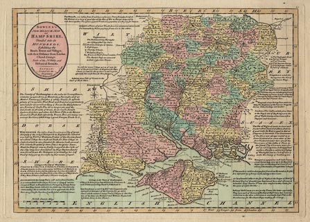
Map, hand coloured engraving, New Medium Map of Hamp Shire ie Hampshire,
scale about 7 miles to 1 inch, by Bowen 1767, published in Bowles's New Medium
English Atlas by Bowles and Carver, 69 St Paul's Churchyard, London, after
1793.
|
|
The map, by the late Emanuel Bowen and Thomas Bowen, was originally published in
Atlas Anglicanus by Thomas Kitchin, 59 Holborn Hill, London, 1767. There are
panels of descriptive text in spare spaces around the map.
|
|
This example has never been folded and bound in an atlas, but has the plate
number 15.
|
|
map feature:-
|
hand coloured & title cartouche & oval cartouche & compass rose
& scale line & lat and long scales & lat and long grid & sea
tinted & coast form lines & rivers & woods & forests & trees
& relief & hillocks & parks & county & hundreds &
settlements & roads & distances from London |
|
scale line:-
|
12 miles = 45.0 mm |
|
inscription:- |
printed -on- title cartouche, upper left
BOWLES'S / NEW MEDIUM MAP / OF / HAMP SHIRE / Divided into its / HUNDREDS; /
Exhibiting the / Roads, Towns and Villages; / with their Distances from London,
/ Church Livings, / Seats of the Nobility, and / Historical Remarks. LONDON: /
Printed for the / Proprietors / Bowles & Carver, No.69 in St. Paul's Church
Yard.
|
|
inscription:- |
-on- central
-- fleur de lys and crown; height 13.5cm |
|
dimension:- |
wxh, sheet = 43.5x28.5cm |
|
wxh, plate = 332x236mm |
|
wxh, map = 3117x227mm |
|
scale = 1 to 430000 ? (1 to 429158 from scale line said to be statute
miles) |
|
longitude, Winchester = 1d 8.0m W (approx) |
 |
|

|
Map Group -- Bowen 1767 -- with Research Notes
|
 |
|

| top of page |
| MN: 26.6.2004 |


