 Map Group CRUCHLEY 1856


map maker

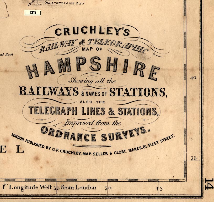
CRUCHLEY'S RAILWAY & TELEGRAPHIC MAP OF HAMPSHIRE Showing all the RAILWAYS & NAMES OF STATIONS, ALSO THE TELEGRAPH LINES & STATIONS, Improved from the ORDNANCE SURVEYS. LONDON. PUBLISHED BY G. F. CRUCHLEY, MAP-SELLER & GLOBE MAKER, 81, FLEET STREET.in a restrained riot of fonts.
up is N
scale

SCALEThe scale line is chequered in miles, 10 miles = 93.3mm, gives a scale of 1 to 172491 assuming a statute mile, ie the map scale is about:-
1 to 170000
3 miles to 1 inchThe latitude scale provides another indicator of scale. 40 minutes of latitude = 413 mm gives a scale 1 to 179691. The map scale is about:-
1 to 180000
3 miles to 1 inch
scale

Printed in the map borders are scales of latitude and longitude for a rectangular projection; chequered at 1 minute intervals, labelled at 5 minute intervals and degrees. The bottom border is labelled:-
Longitude West from London

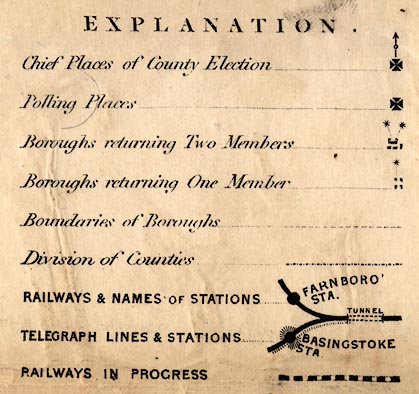
EXPLANATION
Chief Places of County Election [maltese cross with a dot and arrow]
Polling Places [maltese cross]
Boroughs returning Two Members [2 asterisks attached to place symbol]
Boroughs returning One Member [1 asterisk attached to place symbol]
Boundaries of Boroughs [dashed line]
Division of Counties [dot dash line]
RAILWAYS & NAMES OF STATIONS [very bold line, double dotted line labelled TUNNEL, large dot and station name in block caps]
TELEGRAPH LINES & STATIONS [hatching added to railway line and station dot]
RAILWAYS IN PROGRESS [very bold dotted line]This clearly takes many symbols used on the map for granted, conventional and familiar to the intended users. The symbols remarked are for electoral data which is still relatively new since the Reform Act 1832 and subsequent acts, and for railways and telegraphs which are the very latest thing.
sandbanks
foreshore
rocks
sea marks
lighthouses
islands
buoys
wrecks
ENGLISH CHANNEL
CHRISTCHURCH BAY
THE SOLENT
SPITHEADForeshore mud or sand flats and sandbanks are drawn with a dotted line and might be labelled, eg:-

Bramble
Middle
Horse Sand
Spit BankRocks are shown on the Shingles by little Xs.

SHINGLESA conical buoy is drawn and labelled:-

Royal Georgemarking the wreck of this ship which was a hazard to navigation, removed later in the century.
A sea mark is shown by labelling, only:-
Jack in the Basketand there is a:-
Light Ho.indicated on Hurst Spit.
Some of the smaller islands are shown within Portsmouth and Langstone Harbours, some labelled, eg:-
Horsea I.
Whale I.
coast shaded
harbours
shipyards
headlands
coast appearance

The coast line is emphasised by shading. A variety of coastal features are labelled, eg:-
Hengistbury or Christchurch Head
Stans Ore PointAt a few places there is an attempt to show the coast appearance; for instance, indication of low cliffs between Browndown Point and Titchfield Haven:-

Harbours are noticed and labelled, but the name is sometimes implied by the nearby place as at Christchurch where is:-
Haven
Titchfd. Haven
Langston Harbour
PORTSMOUTH HARBOURwhich also has:-

Dock YardThere is another
Dock Yardat Buckler's Hard on the Beaulieu River.
castles
fortifications

Hurst Cas.
Calshot Cas.
Netley castle
Browndown Fort
Fort Monkton
Block H.
South Sea castle
Forts (on Southsea shore)
Cumberland Ft.Southsea Castle's symbol looks a bit like a square with buttresses, but the symbols are not particularly distinctive.
Fortifications are shown by zigzag lines, suggestive, but no better, of polygonal artillery style fortifications, at Gosport, Portsmouth and Portsmouth dockyard:-

and all along the north shore of Portsea Island, labelled:-
The Li[n]es
ponds
bridges
fords

Rivers are drawn by wiggly lines tapering inland from their estuaries which have shading continued in from the coast. Broader parts of rivers are drawn with a double line. A few rivers are labelled, eg:-
Avon R
Crockford Water [east of Boldre]
Blackwater River
Ex or Beaulieu River
Dark Water [near Stans Ore Point]Some of the river names are less common on other maps. An upper part of the Test, about Whitchurch, is labelled:-
Anton Rbut so is the tributary of the Test from Andover. The tributary usually called the Bourne Rivulet, through St Marty Bourne, is labelled:-
Test R.Just what firm test can be used to determine which branch at a junction is the tributary and which the main stream!
Braiding is drawn, for example at Breamore on the Avon. And all the river systems are drawn with many tributaries.
Some ponds are marked, and might be labelled, eg:-

Woolmer Pond
Gomer Pond (near Browndown)The pond at Alresford is drawn but not labelled. Two ponds are shown at Fleet, named only by the adjacent:-
FLEET POND STATIONon the railway.
A pond might be shaded, as at Woolmer, or not, as at Alresford.
Bridges are mostly indicated by a road interrupting a river. Some are named, eg:-

Avon Bri. [over the Avon at Avon]
Iford Br.
Kitcomb Br [near Leckford]Other bridges are suggested by place names, such as Fordingbridge, Stockbridge, Horse Bridge Station, etc. There is a gap in the river drawn at:-

Palmers Ford
hill hachuring

Relief is indicated by hill hachuring, with several of the hills or groups of hills labelled, eg:-
Borroughclere Hill
Weavers Hill [NE of Liss]
Winchester Hill [Old Winchester Hill]
Portsdown Hill
Quarley Mount
Mount Pleasant [N of Sherfield English]
Duckholt Hillswhere Buckholt Forest should be marked and labelled.
Again there are place names on this map which may not occur on other maps.
Other hill names might be impied by settlement names, Filmer Hill for instance.

Beacon Hill [by Dibden, the Hythe Beacon]
Beacon Hill [N of Farley]
forests
trees
vegetation
commons

Woods and forests are marked by group of tree symbols, some labelled, eg:-
Faccombe Wood
Dole Wood
NEW FOREST
FOREST of BERE [East Bere Forest]
Alice Holt Forest
WOOLMER FORESTwhich last has no trees, a reminder that 'forest' is a hunting area rather then a lot of trees.
There is a:-

Boundary Treemarked as a single tree south of Dibden in the New Forest area. There are the:-

Half Moon Treesmarked as a small group east of Paulton Park.
A number of downs, commons, heaths, etc are labelled, eg:-
Beaulieu Heath
Arnwood Common
Easton Down [E of Winchester]
Waltham Chace
Longwood WarrenSome of the common areas are marked by pecking plus small bush symbols. This is also used for undergrowth in some woodland areas of East Bere Forest and is all that is marked for Woolmer Forest.

Husborn Park
Bramshill Park
Tangier

The county boundary is a dashed line, except where a river or the sea coast takes over the function. (The boundary between the electoral 'County Divisions', north and south Hampshire, is a dot dash line, as shown in the table of symbols.) The county boundary is tinted because it is also a division boundary.
The boundaries between adjacent counties are irregular, some shown, eg Wiltshire/Dorset, some not, eg Surrey/West Sussex. The detached part of Wiltshire north of Silchester is drawn. The detached part of Hampshire in West Sussex is not drawn.
Adjacent counties are labelled, eg:-
WILT SHIRE

Hundred boundaries are dotted lines. The hundred names are in large light block caps across the map, eg:-
WHERWELL HD.
ALTON HUNDRED
PART OF ODIHAM H.

The table of symbols gives a fine dashed line for borough boundaries. These are not prominent among all the other detail on the map; and remember that the map postdates the Reform Act 1832 and other reforms, that some old boroughs are no more. The boundaries around Winchester and Lymington, for example, are easy to see; that round Andover is less easy, or absent.
streets
electoral data

WINCHESTER [maltese cross and arrow, square, two stars]This city has other churches as well, named, eg:-
St Cross
St GilesWinchester has a maltese cross and arrow indicating that it is a Chief Place of County Election (so is Southampton) and has two asterisks indicating that it returns two members to Parliament. The borough boundary is a dashed line.
A smaller town is shown by blocks grouped on streets making a street plan, plus a church shown by a building with a tower; labelled in upright block caps, eg:-

ALTONThis town has a maltese cross to show that it is a Polling Place.

SelbournThere might not be a church.

Oakhanger
Upr. Sombourn
Titchborne HouseMost houses are drawn with a park, eg:-
Boldrewood LodgeThere are named houses without any symbol, eg:-
Blue Hou.east of Hartley Westpall.
Ford F. [SW of Odiham]
Priory Fa. [S of Hartley Mauditt]
Farm [7m W from Andover by road]
turnpike gates
road distances
distances from London
Some routes are named. The London - Basingstoke - Andver - Salisbury road is:-
The Great Western RoadThe Andover - Amesbury continuation of the route is called the:-
Warminster RoadThe road across the county through Wickham and Cosham is:-
The Salisbury & Bath RdIn all this can be seen changes of perception of routes from those of Ogilby's period. It would be interesting to compare the route names with earlier sources; Ogilby's route titles, Cary's itinerary names, in particular.
Roads out of the county have their destination or start, given, perhaps with a distance. Eg:-
to Chichester from Havant 9M.
from Amesbury to Andover 14M.
from Cranborne
to NewburyA few roads have names, eg:-

Popham La
Gravel Hill (SW of Rake)A few junctions are named, eg:-

Lobcomb Cornerand
Cross Wayson Hinton Common north of Christchurch.
Two gates are labelled:-
Hatchet GateWSW of Beaulieu, and
Hampshire GateNNE of Tangley. These might be turnpike gates?
Some of the larger roads are marked with distances each mile, excepting where there is no space to engrave the number. The distances might be from London, for example on the road entering the county at Blackwater are numbers 31, 32, 33, etc on the route through Basingstoke. Where the route divides, at Basingstoke, the numbers continue correctly down each branch. Other roads have distances from a local start; thus the road from Stockbridge is numbered eastwards towards Basingstoke. This road's numbering starts again near Wonston. Following the numbering you can see that Cruchley does not think of the route from Popham corner being a route to Salisbury, but a route to to Winchester, to which the numbering leads (though the Salisbury route is named 'London Road' just NE of Wonston).


Railways are added to the map, engraved over and obliterating some original features. They are shown by very bold solid lines with large dots for stations, with equally bold dotted lines for routes 'in progress' which may or may not have happened:-

Routes are labelled in bold upright block caps along the lines, eg:-
SOUTH WESTERN RAILWAY MAIN LINEfor the London and Southampton Railway which had become the London and South Western Railway, LSWR, in 1839. Stations are also labelled in bold upright block caps, eg:-
WINCHESTER STA.
ANDOVER JUN STA.Tunnels are shown by a double dotted line, the width matching the width of the bold solid line, labelled:-

TUNNELfor example, north of Micheldever Station.
A thorough analysis of the railways might be interesting. At least one of the lines in progress was never built, that shown from Petersfield to Bishops Waltham.
See:-

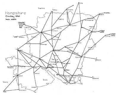
BASINGSTOKE STAwith the telegraph along the LSWR and the Berks and Hants lines, and a telegraph station.
The telegraph from near Brockenhurst Junction to Lymington follows the line of the road not the railway, going to a telegraph station in the town. This line continues independently of railway to Keyhaven and thence to Hurst Castle telegraph station, and across the mouth of The Solent to the Isle of Wight, and by land to an end telegraph station at Cowes.
See:-

at Lymington, and

at Hurst Castle.
The telegraphs mapped are electric telegraphs, the 'two needle' telegraph invented by Cooke and Wheatstone. Railways were probably the best customers for this then new form of communication. See:-
Kichenside, G & Williams, A: 1998: Two Centuries of Railway Signalling: Oxford Publishing:: ISBN 0 86093 541 8

Basingstoke Canal
Arundel Canal

Barge R.

Stockbridge Courselabelled, and marked by an oval of double dotted line north west of the town.
Winchester Race Grd.is labelled on Worthy Down north of the city.
Race Gro,labels the oval of Lyndhurst race course, just north east of the town.
tumuli
hillforts
roman camps
roman roads

Quarley Mount and Camp [hillfort]
Keats or Canutes Barrow
Camp [Danebury hillfort]
Roman Camp [Old Winchester Hill earthwork]
Amphitheatre [W of Silchester]

Cromwells Camp [SE of Winchester]
Oliver Cromwell's Camp [W of Winchester]There are also roads labelled:-
Roman Roadas just south of Dibden which may or may not be that. And roman roads like:-

Port Way
Bottom Innabout mile 59 on the road to Portsmouth south of Petersfield. And:-

Sun Inn
Wheatsheaf Innboth on Popham Lane outside Basingstoke.
Innat mile 43+ on the Western Road west of Nately Scures.
Wood Crossis shown by a cross on Nursling Common.

Wilverly Post [drawning of a finger post?]
Picked Post [E of Ringwod]
Wollymore Post [E of Hale]
Rufus's Stoneis labelled in the New Forest.
barracks
hospitals

NTH. CAMP
STH. CAMPwith North Camp Station nearby.
On Portsea Island, partly overprinted by the railway, is:-
H[ors]ea B[ar]racksAnd:-
Haslar Hosp
NETLEY HOSP.are marked and labelled.
water mills
windmills

Funtly MillNorth of Bentworth there is a post mill symbol:-


Western Railway
Cruchley shows:-
FARNBORO STA. (and line eastward)
FLEET POND STA
BASINGSTOKE STA.
MITCHELDEVER STA.
WINCHESTER STA
BPS. STOKE STA.
STA (at Southampton)labelled:-
SOUTH WESTERN RAILWAY / MAIN LINE
Gosport
branch railway
Cruchly shows:-
BPS. STOKE STA.
STA (at Gosport)labelled:-
STH. WESTN. RY. / (GOSPORT BRA)
branch railway
Cruchley shows:-
BPS. STOKE STA. (junction at north)
CHANDLERS FORD STA.
ROMSEY STA.
DUNBRIDGE STA.
DEAN STA. (Hampshire Wiltshire border)
SALISBURY STA. (Wiltshire)Labelled:-
STH. WESTN. RY. / (SALISBURY & BISHOPSTOKE)
Dorchester Railway
Cruchley shows:-
STA. (Southampton, and junction to north)
STA. (west side of Southampton)
MILLBROOK STA
REDBRIDGE STA. (junction to west)
ELING JUN STA.
LYNDHURST ROAD STA.
BEAULIEU RD. STA.
BROCKENHURST JUNCN. STA.
CHRISTCHURCH ROAD STA.
RINGWOOD STA (and line westward)Labelled:-
STH. WESTN. RY. / (SOUTHAMPTON & DORCHESTER)
Portsmouth
branch railway
Cruchley shows:-
CHICHESTER STA. (West Sussex, and line east)
EMSWORTH STA.
HAVANT STA
(junction east of Cosham)
STA (at Portsmouth)Labelled:-
BRIGHTON & STH. COAST RY. / PORTSMOUTH, CHICHESTER & BRIGHTON
branch railway
Cruchley shows:-
FAREHAM STA. (junction south of)
PORCHESTER STA
COSHAM STA
(line eastward to junction)
Hampshire Railway
Cruchley shows:-
(line from north)
BASINGSTOKE STA.Labelled:-
GRT. WESTN. RY. / (BASINGSTOKE & READING)
and Reigate Railway
Cruchley shows:-
SANDHURST STA. (Surrey, and line northward)
FARNBORO STA. (not LSWR)
NTH. CAMP STA.
ASH STA. (Surrey, and line south to junction east of Tongham)Labelled:-
STH. EASTN. RY. / (READING. GUILDFORD & REIGATE BRA.)
branch railway
Cruchley shows:-
TONGHAM STA (Surrey, and line east to junction and beyond)
FARNHAM STA. (Surrey)
ALTON STA.Labelled:-
STH. WESTN. RY. / (ALTON & GUILDFORD BRA.)
Salisbury Railway
Cruchley shows:-
OAKLEY STA. (junction east of)
OVERTON STA
WHITCHURCH STA.
ANDOVER JUN STA
GRATELEY STA.
SALISBURY STA. (Wiltshire, and line westwards from junction to north)Labelled:-
STH. WESTERN RY. / (SALISBURY & ANDOVER BRA)
Cruchley shows:-
BROCKENHURST JUNCN. STA. (junction west of)
LYMINGTON STA (town; there is a peculiar symbol on the line to north west)
Cruchley shows:-
LIPHOOK STA. (and line eastward)
LYSS STA.
PETERSFIELD STA.
(tunnel at Butser Hill)
ROWLAND CAS. STA.
HAVANT STA
Christchurch
and Bournemouth
Railway
Cruchley shows:-
RINGWOOD (junction west of)
AVON STA.
HURN STA. (now Dorset)
CHRIST CH STA. (now Dorset)
Railway
Cruchley shows:-
BOTLEY & BP. WALTHAM STA.
STA (at Bishops Waltham)
Bishops Waltham
railway
Cruchley shows a line in progress:-
STA (at Bishops Waltham)
PETERSFIELD STA.
and Pier Co
Cruchley shows:-
GOSPORT (junctions at and near)
(end and pier at Stokes Bay)
Cruchley shows:-
PETERSFIELD STA.
MIDHURST STA. (West Sussex)
Alton Lines,
Railway
Cruchley shows a line in progress:-
ALTON STA.
(through Alresford)
WINCHESTER STA. (junction N of)
Redbridge Railway
Cruchley shows:-
ANDOVER JUN STA
STA (south side of Andover)
CLATFORD STA
FULLERTON STA
STOCKBRIDGE STA
HORSE BRI. STA.
MOTTISFONT STA
(junction north of Romsey)Labelled:-
ANDOVER AND REDBRIDGE RAILY. / STH. WESTN. RY.
Cruchley shows the line to Warblington completed and the line to Hayling in progress:-
HAVANT STA
(unnamed station at Warblington)
(end at south of Hayling Island)
Netley Railway
Cruchley shows a line in progress:-
(junction north of Southampton)
(end at Netley)
Junction Railway
Cruchley shows a line in progress:-
(junction between Dean and Salisbury, Wiltshire)
(crosses Hampshire near Fordingbridge)
(junction in Dorset, east of Romsey)


CRUCHLEY'S RAILWAY AND TELEGRAPHIC County Map of HAMPSHIRE. N.B. These excellent County Maps, larger and superior to any other for Railway Travelling, are offered to the Public at SIXPENCE EACH, the price at which the most inferior County Maps are sold. The names of all the Railways and Stations are inserted on these Maps, likewise the Companies to which they belong. SIXPENCE COLOURED. N.B. Sent Postage Free on Receipt of Seven Stamps. G. F. CRUCHLEY, Map Publisher and Globe Manufacturer, 81, FLEET STREET. SOLD BY ALL BOOKSELLERS & RAILWAY STATIONS.


