 Map Group DARTON 1830s


map maker

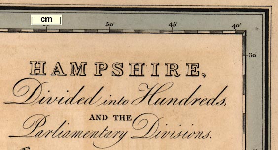
HAMPSHIRE, Divided into Hundreds, AND THE Parliamentary Divisions.Printed at the bottom:-
LONDON: WILLIAM DARTON & SON, HOLBORN HILLInternal evidence dates the map to soon after 1831.

There is a vignette engraving of the Church of St Cross.
NOTE
HAMPSHIRE in its civil and ecclesiastical jurisdiction, (including the Isles of Jersey, Guernsey, Sark, and Alderney;) is comprehended in the diocese of Winchester. It is estimated at 64 miles in length and 40 in breadth, its superficial contents are calculated at 1,042,000 Acres. It is divided into 36 hundreds, which contain 1 City, 21 Market Towns, & 278,887 Inhabitance.
According to Act of Parliament this County is divided into two Divisions, Vizt. North & South, and sends to Parliament 16 Members, 2 Knights for the Nth. Division & 5 Boro' Members, 2 Knights for the Sth. & 7 Boro' members. The principal rivers are the Itching, the Avon, the Boldre Water, the Exe, the Anton, and the Test or Tese.

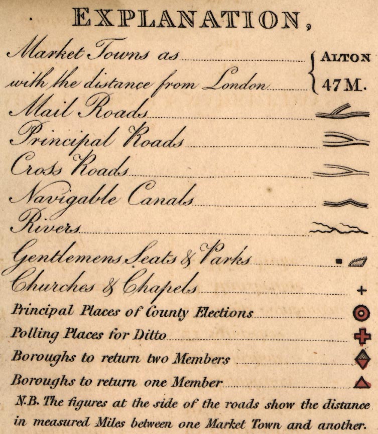
EXPLANATION
Market Towns as ... ALTON
with the distance from London ... 47 M.
Mail Roads ... [triple line, light light bold]
Principal Roads ... [double line, light bold]
Cross Roads ... [narrower double line]
Navigable Canals ... [triple line, light bold light]
Rivers ... [wiggly line]
Gentlemens Seats and Parks ... [block, outline with fence palings]
Churches & Chapels ... [cross (+)]
Principal Places of County Elections ... [ring, tinted red]
Polling Places for Ditto ... [open cross (+) tinted red]
Boroughs to return two Members ... [rhombus ie double triangle, tinted red, upper triangle shaded]
Boroughs to return one Member ... [triangle tinted red]
N.B. The figures at the side of the roads show the distance in measured Miles between one Market Town and another.
scale

SCALE OF MILESchequered and labelled in miles. The 10 miles = 55.3 mm gives a scale 1 to 291021 assuming a statute mile. The map scale is about:-
1 to 291000
4.5 miles to 1 inch
up is N

Printed in the map borders are scales of latitude and longitude for a rectangular projection; chequered at 1 minute intervals, labelled at 5 minute intervals. The map includes from 0d 40m to 1d 55m W, from 50d 29m to 51d 31m N; the whole of Hampshire and the Christchurch area of Dorset, and the Isle of Wight.
The bottom scale is labelled:-
Longitude West from GreenwichReading from the scales the:-
longitude, Winchester = 1d 17.1m Wwhich is in fair agreement with a prime meridian at Greenwich, from which winchester is 1d 18.1m W.
sea plain
wrecks
THE SOLENT
SOUTHAMPTON WATER
SPITHEAD
ENGLISH CHANNEL
Christchurch bay
Hurst Road
Dibden BayThe site of the wreck of the Royal George is marked
harbours
headlands
lighthouses

The coast is emphasised by being drawn with a wiggly line which is for effect, not representing the exact coast line.
Harbours are shown, and might be labelled, eg:-
Portsmouth Harbour
LANGSTON HARBOUROthers are implied by harbour or haven placenames.
Some headlands, etc, are labelled, eg:-
Hengistbury Head
Needs Ore Point
Stans Ore Point
Browndown PointAt Hurst Spit there are:-

Light Houses
castles
fortifications

Hurst Castle
Calshot Castle
South Sea Castle
Fort Monkton
Cumberland FortThere are suggestions of polygonal fortification for Southsea Castle and at Portsmouth:-

ponds
bridges

River Avon
Boldre Water
Lymington CreekBraiding might be shown.
Some ponds are shown:-

Fleet Pond
Woolmer PondBridges are implied, perhaps, by roads crossing rivers. A few are labelled eg:-
Badge Bridge
Hartford Br.
hill hachuring

Portsdown Hill
Gilbert Hill
Tatchbury Mt.

Beacon Hillat Farley Mount. Toothill doesn't even get a hill!
forests

There are groups of small tree symbols marking woodland, some of which are labelled, eg:-
Holt Forest
Woolmer ForestThe impression is that the map maker is trying to show woods that are now; not harking back to the ancient royal forests. Trees are drawn within parks.

Husborne Parkin which there are drives among the trees.

The county boundary is a dotted line, the boundary is tinted as a hundred boundary.
Contiguous counties are labelled, eg:-
SURREY
Pt. of WiltsThe detached part of Hampshire, south of Haslemere, is not shown.
table of hundreds

Hundred boundaries are fine dotted lines, each tinted a different colour. The hundred areas are keyed by number to a table of hundreds printed upper left:-
REFERENCE to the HUNDREDS
1 Alton
2 Andover
3 Barton Stacey
...
36 Wherwell

NORTH DIVISION
SOUTH DIVISIONThe boundary is tinted blue on the north side, pink on the south (which would not do in the present era of party politics).
Borough boundaries are drawn by a line with spots on it, tinted a dark blue:-

These boundaries cut across the hundred boundaries.
distances from London
electoral data

WINCHESTER / By Farnham 65 1/4 / Basingstoke 62 1/2 [red ring, red cross, red rhombus]Principal place of county election; polling place; returns 2 members to Parliament. The figures are distances from London.

ANDOVER / 63 1/2 [red cross, red rhombus]
West Worldham

Middle WallopA house and other features might be marked and labelled the same way.
road distances
post roads

Roads are marked by a double line, graded into post roads, principal ie ?turnpike roads, and and cross roads. Principal roads are a double line, light bold; cross roads are a narrower double line, light light. The post or mail roads have a third line down the middle:-

Road distances between town are given by a figure across the road. These must be read with some care.

Basingstoke Canal
Andover Canal
Salisbury Canal
[Itchin] CanalThe last has a tunnel indicated by the centre bold line being dotted. Notice that the Portsmouth Canal is not shown, though it had been closed only shortly before?
hillforts

Quarley Hill Campmarked by a square symbol on the hill.
roman roads

Roman Roadsouth of Stockbridge, crossing the Test near Kings Somborne.
Wheatsheaf Inn6m southwest of Basingstoke, and:-

Raven Innnear Hook.

north west of Stockbridge, and:-
Worthy Down Course

Wilverley Post


market days
MARKET TOWNS & MARKET DAYS,
Alresford ..................... Th.
Alton ........................ Sat.
Andover ...................... Sat.
Basingstoke .................. Wed.
Bishop's Waltham ............. Fri.
Christchurch ................. Mon.
Fareham ...................... Mon.
Fordingbridge ................ Sat.
Gosport ...................... Sat.
Havant ....................... Sat.
Kingsclere .................... Tu.
Lymington .................... Sat.
Odiham ........................ Tu.
Petersfield .................. Wed.
Portsmouth ............ TuTh & Sat.
Ringwood ..................... Wed.
Romsey ........................ Th.
Southampton ......... Tu.Th. & Sat.
Stockbridge ................... Th.
Whitchurch ................... Fri.
WINCHESTER ............ Wed. & Sat.


