 Map Group DUNCAN 1833


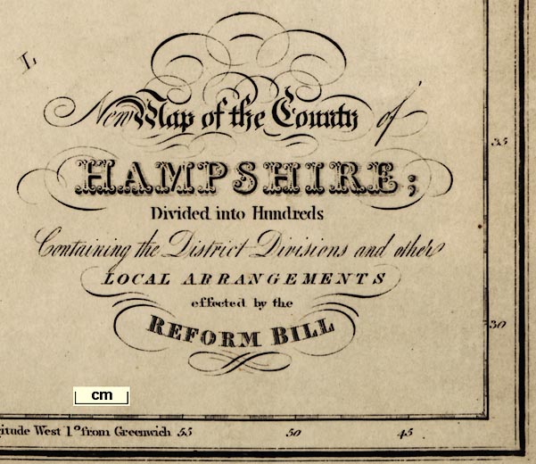
New Map of the County of HAMPSHIRE; Divided into Hundreds
Containing the District Divisions and other LOCAL ARRANGEMENTS effected by the REFORM BILL
compass rose
up is N

Printed on the left is a compass rose; no circle, star points for cardinal and half cardinal directions, North marked by a fleur de lys. The map is printed with North at the top of the sheet.
scale

SCALEchequered and labelled at 1 mile intervals. The 15 miles = 87.2 mm giving a scale 1 to 276837 assuming a statute mile. The map scale is about:-
1 to 280000 ?
4 miles to 1 inchA scale can be estimated from the scale of latitude, 40 mins lat = 267mm gives 1 to 277948, which agrees with the above.

Printed in the map borders are scales of latitude and longitude for a rectangular projection; chequered in minutes, labelled at 5 minute intervals. The map includes 0d 42m to 1d 58m W, 50d 28m to 51d 30m N; the whole of Hampshire and the Isle of Wight. The bottom scale is labelled:-
Longitude West from Greenwichand the
longitude, Winchester = 1d 18m Wagrees with this.

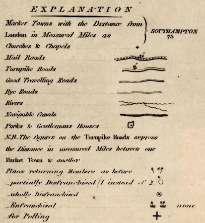
EXPLANATION
Market Towns with the Distance from London in Measured Miles as ... SOUTHAMPTON 75
Churches and chapels ... [cross (+)]
Mail Roads ... [broad double line, light bold, plus dotted line down centre]
Turnpike Roads ... [broad double line, light bold]
Good Travelling Roads ... [narrow double line, light bold]
Bye Roads ... [narrow double line, light light]
Rivers ... [wiggly line]
Navigable Canals ... [triple line, light bold light]
Parks and Gentlemans Houses ... [outline with palings, pecked inside]
N.B. The figures on the Turnpike Roads express the Distance in measured Miles between one Market Town & another
Places returning Members as before ... [one or two stars]
- partially Disenfranchised (1 instead of 2) ... [circle and 1 star]
- wholly Disenfranchised ... [dot and circle]
-Enfranchised ... [bold line with 1 star, or with 2 stars]
- for Polling ... [large plus sign]
sea plain
depth contours
ENGLISH CHANNEL
North Channel
Stokes Bay
SPITHEADIn Southampton Water, the larger harbours, and off Lymington, there are ?depth contours showing the main channels.
coast shaded
headlands
harbours

The coast line shaded for emphasis.
The two larger harbours are labelled:-
PORTSMOUTH HARBOUR
LANGSTON HARBOURSome headlands are labelled, eg:-
Needs Ore Point
castles
fortifications

South Sea CastleAn angular line around Portsmouth suggests the town's fortifications.
ponds
bridges

Enborne R.
Beaulieu Riv.
Itching R.
Boldre W.Braiding may be shown, for example the complicated streams of the Avon south of Ringwood:-

In a few rivers the navigable channel is indicated, for example in the estuary of the Itchen up to South Stoneham, where the navigation cuts begin.
All Hampshire's main rivers are shown, with some tributaries.
Alresford Pond is drawn, but not labelled. But:-

Woolmer Pond
Fleet Pondare more clearly drawn in outline, and shaded. Other ponds are shown, for example in the park at Dogmersfield.
Bridges are mostly implied where roads cross, and interrupt, rivers. A few bridge places are named, eg:-
Red bridge [might be the settlement]
bridge [Test, S of Timsbury]
Pot Br. [N of Odiham]
hill hachuring

Relief is shown by hill hachuring. While this is attractive to the eye, it does clutter up the engraving, and as it is done, in narrow ridges, doesn't provide an overall impression of the land form. A few hills are labelled, eg:-
Quarley Hill
Longstock H
Bridgers Hill [no hachures, NE of Liss]
Toot Hill [or is this the settlement?]The last points up a general problem with labelling. English places names for settlements often arise out of geographic features. How do you know what is a name for a feature, and what for a settlement? And sometimes: what name is just a description of the feature, 'wooded hill', and what is a name 'Wooded Hill', when there is a tendency to label everything with leading capital letters.

Beaconnot clearly attached to any mark.
Beacon Hnorth of Exton could be labelling the settlement, but reminds us of the beacon. Otherwise beacons are not much noticed; they are not important in the early 19th century.
forests

Alice Holt W.
NEW FOREST
Otterwood [SE of Beaulieu]Woolmer Forest is not marked by trees, which is right, nor labelled.

Parks are drawn in outline with vestigial fence palings. The interior is pecked and might have a building block, pond, etc. The parks shown include modern creations, eg:-
Rose Hill Pa.south east of Malwood, as well as older parks, eg:-
Hockwood Park [Hackwood]Some parks are labelled by their house, eg:-
Basing Ho. [SW of Colemere]

The county boundary is a dashed line, except where another feature, river or road, takes over. Adjacent counties are labelled, eg:-
SUSSEXbut their boundaries are not drawn. The detached part of Hampshire in Sussex is shown, labelled:-
Pt. of Hampshireand the two detached parts of Wiltshire are drawn on the northern border. A very few places, Farnham, Salisbury, Newbury, Ludgershall, Chichester, are marked and labelled, for continuity of the roads.
table of hundreds

Hundred boundaries are dotted lines. The areas are labelled with a number keying it to a table of hundreds printed lower left:-
REFERENCE to the HUNDREDS
Pastrow ... 1
Evingar ... 2
Kingsclere ... 3
...Be careful reading the numbers. The hundred numbers are a little larger, but easily confused with town distance and road distance numbers.
distances from London
electoral data

WINCHESTER / 63 [cross; 2 stars]

PETERSFIELD / 54 [cross; 1 star]
STOCKBRIDGE / 66The number with the name is the distance from London. A cross signifies a polling place; the stars indicate the number of members returned to Parliament.

Lower Wallop

Middle Wallop
OakhangerThis style of lettering is also used for any other feature.
turnpike roads
post roads
road distances

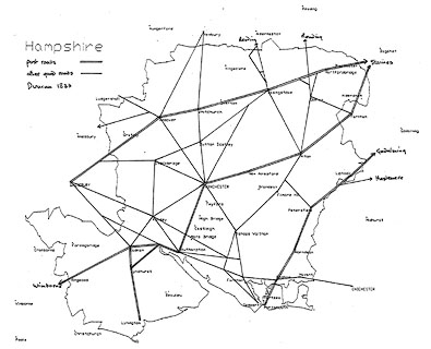
A comprehensive network of roads is shown by double lines. Four sorts of road are distinguished, explained in the table of symbols.
The greater roads, turnpikes, are drawn by broad double lines, light bold. Road distances from town to town are given by figures each mile, from a town - you might have to puzzle out which town, which way. Post roads have an additional dotted line down the middle. Other 'good' roads are drawn narrower, but with light and bold lines. Smaller 'bye' roads are narrow with light and light lines.

[London to Lands End Road] from Staines, Middlesex; across Surrey; then Blackwater, Hartford Bridge, Basingstoke, Whitchurch, Andover, and Middle Wallop, Hampshire; to Salisbury, Wiltshire, and west.
[London to Southampton Road] from Staines, Middlesex; across Surrey; across a corner of Hampshire; then Farnham, Surrey; through Alton, New Alresford, Winchester, to Southampton, Hampshire.
AND continued through Red Bridge, Cadnam, and Ringwood, Hampshire; into Dorset, towards Wimborne.
AND a branch off at Red Bridge, through Lyndhurst, to Lymington, Hampshire.
[London to Portsmouth Road] from Godalming, Surrey; through Liphook, Petersfield, Horn Dean, and Cosham, to Portsmouth, Hampshire.

Canals are shown by a triple curvy line, light bold light. The following are shown:-
Andover C.
Southampton Canal
Ball Mill

Picked Post [ENE of Ringwood]
Welmer Post [ESE of Hale]
Winkton Post [NNW of Milton]

The Hut [N of West Meon]
Rising Sun [N of Bashley]
Raven [E of Hook]
Public Ho. [N of Paultons Park]
Dean Gate Inn [W of Church Oakley]The last is a reminder of turnpike gates.
The Maze
Monument
roman roads

Roman Road

Race Course
Brick Kilns
Cabbage Garden


DISTRICT DIVISIONS
North
Alton
Andover
Basingstoke
Kingsclere
Droxford
Odiham
Petersfield
Winchester
South
Fareham
Lymington
Ringwood
Romsey
Southampton(Should it be Bishops Waltham rather than Droxford?)
It is interesting that this map, drawn very soon after the Reform Act 1832, shows changes as well as the new situation, it bothers to show the disenfranchisements:-
Places returning Members as before ... [one or two stars]
- partially Disenfranchised (1 instead of 2) ... [circle and 1 star]
- wholly Disenfranchised ... [dot and circle]
-Enfranchised ... [bold line with 1 star, or with 2 stars]
- for Polling ... [large plus sign]As far as I can tell there are no newly enfranchised places marked in Hampshire; as far as I know there were none.
Printed lower centre of the map is:-
County Members 4. Elections at [bold square]
The electoral status of Hampshire's towns is summarised below:-
| town | polling | place of | members? | |
| place | election | |||
| Alton | + | |||
| Andover | + | 2 members | ||
| Basingstoke | + | |||
| Bishops Waltham | + | |||
| Christ Church | 1 member, was 2 | |||
| Fareham | + | |||
| Fordingbridge | ||||
| Gosport | ||||
| Havant | ||||
| Kingsclere | + | |||
| Lymington | + | 2 members | ||
| New Alresford | ||||
| Odiham | + | |||
| Petersfield | + | 1 member, was 2 | ||
| Portsmouth | + | 2 members | ||
| Ringwood | + | |||
| Romsey | + | |||
| Southampton | + | [] | 2 members | |
| Stockbridge | none, was 2 members | |||
| Whitchurch | none, was 2 members | |||
| Winchester | + | [] | 2 members |


