 Map Group KITCHIN 1750


The map includes the Isle of Wight but the notes are mostly about Hampshire and the part of Dorset that was then Hampshire.


Maps in the Universal Magazine, included in issues from 1747-66, were drawn by Bowen, Seale and Kitchin, from the evidence available it looks as if Kitchin did Hampshire, but this is not certain.


title
engraver
publisher

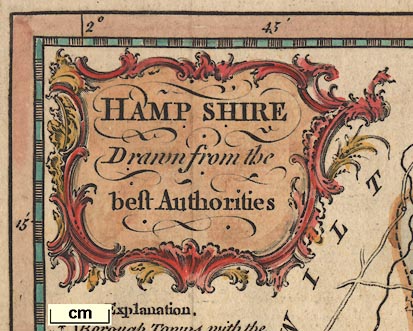
HAMP SHIRE Drawn from the best AuthoritiesPrinted at the top:-
Engrav'd for the Universal MagazineAnd at the bottom:-
Printed for John Hinton at the Kings Arms St. Pauls Curch Yard

The Arms of Southamptonthe blazon:-
per fess argent and gules, three roses counterchanged
compass rose

Lower left there is a minimal compass rose; two lines for the cardinal directions in a circle, north marked by a fleur de lys and east by a cross.
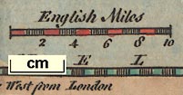
scale

English Milesten miles, chequered at 2 mile intervals.The map scale is about:-
8 "English Miles" to 1 inchAn estimate of scale can be made from town positions, comparing known town-town distances. The map scale is about:-
1 to 560000
9 statute miles to 1 inch
scale

The map borders have rectangular latitude and longitude scales, chequered at 1 minute intervals, labelled at 5 minutes and degrees. Longitude is:-
Longitude West from LondonFrom the scales the:-
longitude, Winchester = 1d 14.4mroughly. This suggests a prime meridian several minutes west of Greenwich, perhaps St Paul's?
Note that 30 minutes longitude is 102.2 mm, giving a scale of 1 to 544610. The map scale is about:-
1 to 540000
8.5 miles to 1 inch

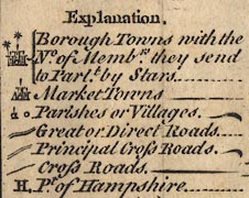
Explanation
[circle, buildings and towers, 2 stars] Borough Towns with the No. of Membrs. they send to Parlt. by Stars
[buildings and tower] Market Towns
[circle and flag pole?] [circle] Parishes or Villages
[double line, light bold] Great or Direct Great Roads
[double line, light light] Principal Cross Roads
[single line] Cross Roads
H, Pt. of Hampshire
coast form lines
harbours

The coast is drawn with form lines which extend into harbours and river estuaries. As well as Portsea, Hayling and Thorney Islands some smaller islands in Portsmouth and Langstone Harbours are drawn. Only:-
Chichester Harbr.is labelled.
coastal defence

Hurst C.
Calshot C.
St. Andrews C.
South Sea Castle
bridges

Itchin R.
Avon R
Tees R.All the main rivers are shown, with some tributairies:-
Stour, River
Avon, River (braiding at Ringwood, etc)
Lymington River
Beaulieu River
Test, River (braiding at Stockridge, and Wallop Brook, River Anton, Micheldever stream etc)
Itchen, River (with Candover stream, and headwaters from ponds near Bighton, not from Hinton Ampner)
Hamble, River
Meon, River
Wallington River
Ems, River
Rother, River (and Cridell Stream)
Wey, River (two arms)
Blackwater River
Hart, River
Whitewater, River
Loddon, River (and Lyde)
Enborn, River
Bridges are mostly implied by a road interupting the river at a crossing. To the east of Havant the minor road, a single line, crosses the Ems by a bridge, drawn by a double line arching over the river. Similarly the single line of minor road crosses the Meon at Wickham by a double line bridge.
There is another example at Fareham:-

hillocks

Relief is shown by groups of hillocks shaded to the eastward. The correspondence beween hill groups and high ground is not easy to follow.
forests

Woodland is shown by groups of tree symbols. Like hillocks these appear all over the map but it is possible to see groups for:-
Forest of East Bere
New Forest
Chute Forest
Pamber Forest (perhaps)
Woolmer Forest (perhaps)Some of these identifications might be wishful thinking.

Dogmersfield
FarnboroughAnd named directly:-
N Parkis drawn as a hamlet, no fence, within the New Forest.

The county boundary is a dotted line, Hampshire is the title of the map. Adjacent counties are named, eg:-
WILT SH.and separated by a dotted boundary lines. Significant places, road destinations, are drawn and labelled outside the Hampshire area; Salisbury, Farnham, Downton, Bagshot, and little more.
The detached part of Hampshire to the east is shown, marked:-
Hexplained as Part of Hampshire in the table of symbols. This is bounded by a chain dotted line. It looks as if the area is attached to Hampshire by a dotted line; look again, this is the Surrey Sussex border. Haslemere is drawn at the north end of this area.

WINCHESTERWinchester has two stars, for its Members of Parliament.
ChristChurchwhich has 2 stars for its Members of Parliament, and is a borough town.

Stockbridgewithout stars, a market town.
SOUTHAMPTONborough town, is an exception, being labelled in italic block caps.

Sutton [Sutton Scotney]
Boldre

Wallop
Burgclear
Mountague H

Three grades of road are drawn about the county, explained in the table of symbols. The main roads include the Ogilby routes.
25/26 - Bagshot, Surrey; Blackwater, Basingstoke, Whitchurch, Andover, Hampshire; to Salisbury, Wiltshire.
30 - from London; Liphook, Petersfield, Horndean, Cosham, Portsmouth, Hampshire.
32 Andover; across Wiltshire border westwards.
39 - Midhurst, West Sussex; Petersfield, Winchester, Hampshire.
51 - Bagshot, Surrey; corner of Hampshire; Farnham, Surrey; Alton, Alresford, Southampton, Hampshire.
53 - Basingstoke, Stockbridge, Hampshire; across Wiltshire border south westwards.
81 - from Berkshire; Kingsclere, Basingstoke, Alton, Petersfield; to Chichester, West Sussex.
83 - across a corner of hampshire at North Tidworth.
97 - Alresford, Winchester, Romsey, Rngwood, Hampshire; towards Poole, Dorset; and Southampton, Winchester, Hampshire.There are additional routes.


