 Map Group KITCHIN 1752 (small)


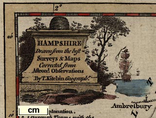
monumental cartouche
map maker

The map's title etc is drawn as if carved on a monumental stone; there is a beehive on top, trees and bushes beside, and a ship sailing on a river.
The title is:-
HAMPSHIRE / Drawn from the best / Surveys & Maps / Corrected from / Astronl. Observations / By T. Kitchin Geographr.

The coat of arms of Southampton decorates the map.
compass rose

There is a minimal compass rose, circle and four cardinal lines, a fleur de lys marking north, a cross for east.
scale
old english mile

The map has a chequered scale line of 15
British Statute Miles15 miles = 43.5mm, assuming a modern statute mile gives the scale 1 to 554946; the map scale is about:-
1 to 550000
9 miles to 1 inch.An estimate of the scale can be made from town positions, comparing known town-town distances using DISTAB.exe. The map scale is about:-
1 to 700000
11 miles to 1 inchThe map maker's miles appears to be an:-
Old English Mile = 1.26 statute milesSource data:-
see:- KIT1DIS.txt
DISTTAB.exe data

The map border is chequered at 2.5 minute intervals (24 divisions per degree) for latitude and longitude, labelled:-
Longit. W. from London.

Explanations form a table of symbols are included in the notes above, describing grades of roads and sizes of settlements. There is also an entry:-
A. Part of HampshireThis refers to the out of county area south of Haslemere, which is labelled with the 'A'.
coast form lines
harbours

The sea coast is emphasised by form lines which continue up estauries and into harbours, and into the lower part of rivers.
None of the Hampshire harbours happens to be labelled. Spit Head is labelled.
bridges
lakes

Major rivers are shewn, tapering upstream. Some are named, eg:-
Avon R.
Tees R.A few lakes are shown, eg at the head of the Swarraton stream.

Bridges are implied by road crossings, ie not for sure.
hillocks

Small shaded hillocks, seem just to be filling space decoratively. They are scattered about liberally.
forests

Little trees, drawn with a shadow, seem just to be filling space decoratively.
New Forrestis labelled as an area rather than as a forest of trees.
coastal defence

Coastal defence castles are:-
Hurst C.
Calshot C.
St Andrews C.
South Sea CastleThe map is to small to have any indication of town walls or fortifications at Portsmouth or Southampton.

Very few parks are shown on this map. A vague circle of fence palings indicates a park at Dogmersfield and at Farnborough, the name
N Parklabels a ?settlement near Beaulieu, this is New Park.

The county boundary is a dashed line.
Great or Direct Post Roads [bold and a light solid line]

Principal Cross Roads [2 solid lines]

Cross Roads [single solid line]

There are segments of dotted lines for roads, perhaps indicating unfenced parts of the way OR, more likely? indicating unclear parts of the way, eg across the heath west of Blackwater.


circle, tower, buildings, name in block caps, eg
WINCHESTERwhose symbol is as for a borough town, with 2 stars.

circle, tower, buildings, star, named in lower case, upright.
Burough Towns with the No. of Members they send to Parliamt. by Stars.eg:- Andover with 2 members.

circle, tower, buildings, but no stars, named in lower case, upright.
Market Townseg:- Bishops Waltham.
hamlet

circle, named in lower case italic.
Parishes or Villageseg Silchester.


Published in 'Historical Descriptions of New and Elegant Picturesque Views of the Antiquities of England and Wales: Being A Grand Copper-Plate Repository of Elegance, Taste, and Entertainment. Containing a new and complete collection of superb views of all the most remarkable Ruins and antient Buildings, such as Abbeys, Castles, Monasteries, Priories ... Accompanied by elegant Letter-Press Descriptions ... To Which Will Be Added ... a Complete Set of County-Maps accurately executed by the best Artists ... Together with an authentic account of Doomsday-Book ... Published under the inspection of Henry Boswell, Esq. F.A.R.S. Assisted by Robert Hamilton, L.L.D. and other ingenious Gentlemen in different Parts of the Kingdom - celebrated for their laborious Researches in the pleasing Study of English Antiquities. London: Printed for Alex. Hogg, at the King's-Arms, No.16, Paternoster-Row, and Sold by all Booksellers, Printsellers, and News-Carriers, in Town and Country,' about 1787-89.
Published in 'Complete Historical descriptions of A New and Elegant Collection of Picturesque Views and Representations of the Antiquities Of England and Wales: ... To Which Arre Added, ... a Complete Set of the County-Maps of England, Scotland, and Ireland, ... By Henry Boswell, Esq. F.A.S. ... London: Printed for Alex. Hogg, at the King's Arms, (No.16) Paternoster-Row, ...' about 1793.
Published in 'The Antiquities Of England and Wales Displayed; Being A Grand Repository of Elegance, Taste, and Entertainment. Containing Copious Historical Descriptions of all the most Remarkable Elegant and Magnificent Ruins and Ancient Buildings; ... including particularly every Article worthy of Notice in that Voluminous and very Expensive Work published By Captain Grose. ... By Henry Boswell, Esq. F.A.S. Assisted by Many Antiquarians, and other Ingenious Gentlemen ... A New Edition, with Alterations And Improvements. London: Printed For Alex. Hogg, At No.16, Paternoster-Row. 1795.'
Published in 'A New and Complete Abridgement or Selection of the most Interesting and Important Subjects in the Antiquities of England And Wales: Being A Complete Collection Of Beautiful Views Of The Most Remarkable Buildings And Ancient Ruins Drawn On the Spot. ... By Francis Grose, Esq. F.A.S. To Which Will Be Added ... A Complete Set Of County Maps, By The Best Artists. ... London: Printed for the Editor, and Sold by H.D. Symonds, No.20, and Alex. Hogg, No.16, Paternoster-Row; and may be had of all the Principal Booksellers and Newsmen, in England, wales, Scotland, and Ireland. MDCCXCVIII.' ie 1798.


