 Map Group -- LEA 1689


With hindsight we might deplore the vandalisation of Christopher Saxton's work. But, the plates are gone anyway, what have we lost? The plates were a serious capital asset, their owners did their best to make good use of them. The additions are not just superficial improvement; there was a systematic attempt to make a better map. The new data includes added coats of arms of local nobility, an index grid, alterations to the coast line, added river names, beacons, improved county boundary, added hundred boundaries and names, many added settlements, roads, historical place names, differentiation of towns as markets, boroughs and bishoprics, and a street map of the county town. There are miscellaneous other additions. This is an impressive project; even if it does result in a messy map!


labelled borders
up is N
As original.
scale
As original.
picture frame border
Mostly as original:-The picture frame border of the map is unchanged but for the addition of gradations and labelling for an index grid to the map. This idea did not come from Speed; Norden had an index grid, but not quite like this.

On the upper border are marks at 1 inch spacing, the intervals labelled a..m (no j); 12 divisions. The marks do not start at the edge of the map, but are arranged to encompass the width of Hampshire. The spacing is not simply related to the map miles on the scale line. Down the left border are similar marks and labelling. And again, the scale does not start at the edge of the map, but does encompass the height of the county area. The index grid is not drawn across the map (which is already full of detail).
street map
coat of arms
table of data

Winchesterwith the coat of arms of the city, and a table of place names keyed to the map by numbers. The map is copied from John Speed's, re-engraved trimmed at east and west sides, no north point, no scale line, the table of places below instead of at the side.
drape cartouche
map maker

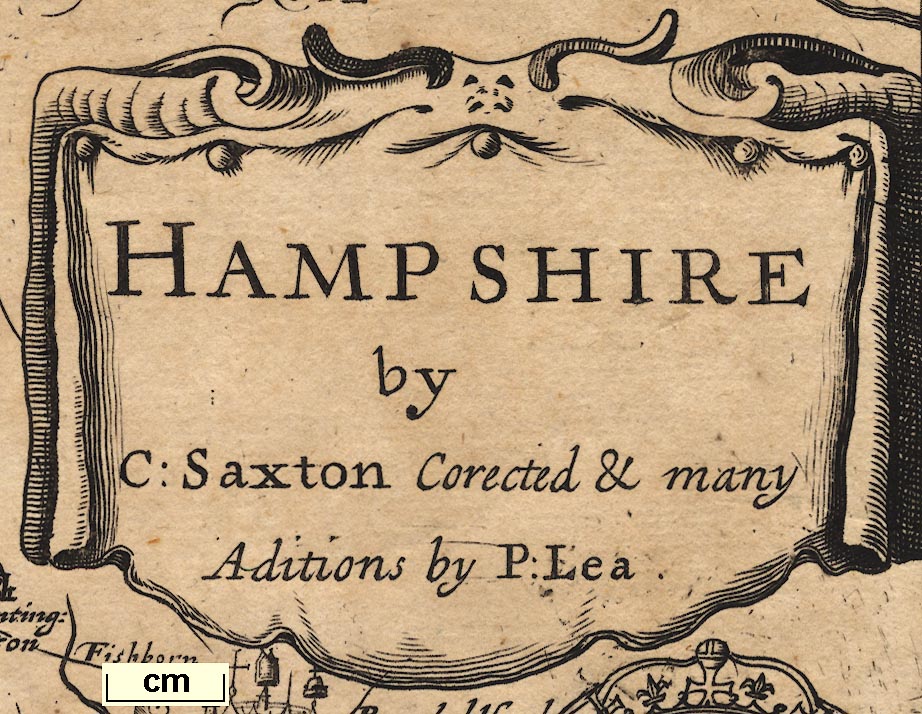
The secondary title cartouche of the original is erased, replaced by a drape cartouche:-
HAMPSHIRE by C: Saxton Corrected & many Aditions by P: Lea

Squeezed in between the swash lettering labelling adjacent counties on the west are five coats of arms of Earls of Winchester, labelled:-
Cliton Ea: of Winchester
Saer Quinsey Ea: of Winchester
Hugh Spencer Ea: of Winchester
Lodo: Bruget Ea: of Winchester
Will: Pawlett Marq. of WinchesterWhile the arms are like Speed's, the name spellings are altered. Under the arms a couple of place names in Wiltshire are lost.
Seckford's arms, lower right on the original, are replaced by a panel of four coats of arms of:-
The Earles of Southamptonlabelled:-
Bevois Earle
Willi: fitz Will: E:
Tho: Wriotheosley
Cha Fitz Roy DAs before the arms are much like Speed's, the names differ. The last, FitzRoy, added 1689-93, was not on Speed's map.
In a spare space in Sussex the royal coat of arms of the Stuarts are fitted, with motto on a garter.
sea pecked
sandbanks

SpitThe sea area at the entrance to Portsmouth Harbour is labelled:-
Spit HeadA sandbank off the S of Hayling Island is added, shown by denser pecking.
The whole coast line of the Isle of Wight is redrawn. This involved re-engraving some of the 'pecking' of the sea, and Hurst Castle.
coast shaded
coast appearance
headlands
harbours

The coast shading has been re-engraved; a more thorough job than Saxton. And there are some changes to the coast line. The lower left corner of the map now shows Poole Harbour with:-
North haven point
South haven pointeach with a castle.

The coast line from Allum Chine to Christchurch Head is drawn with low cliffs, the seaward appearance of the shore.
Christchurch headis labelled, as is:-
Rams headeThe alterations to sea and coast owe little or nothing to John Speed's map.
castles
Mostly as original:-A castle and a tower are shown at Poole Harbour. Because of other work the castle on Hurst Spit is re-engraved, though the label is almost unaltered. A castle labelled:-

Worth ca.is added off Rams Head.
Mostly as original, but:-

River estuaries, which were pecked like the sea, are now engraved with form lines, or, at least, with some stream lines over the shading.
Herford bridgis added as well as the stream's name:-
New mil flu:
Wey R.
hillocks
Mostly as original (and hard to compare!)SE of Clanfield, two small hillocks are added, one with a windmill, a post mill, on top.

Selbone BeaconOn a hillock N of Micheldever a couple of posts are added to a hillock, labelled:-
Patowe beaconsAlthough Speed has the places he does not spell their names quite the same way.
forests
Mostly as original.Although it is not needed, a new label:-
NEW FORRESTis added where the trees are most dense, S of Malwood. And there is an added label:-
ArnwoodThe Shire Oak, which was an addition to our copy of Saxton, is erased.

Two definite rows of trees have been added. One from just S of Ewhurst, passing Hannington, to the pass between two hillocks N of Ashe. The other from just E of Wotton running S to a hillock N of Dummer. What interesting details; what are they?
Mostly as original:-An unlabelled park is added, recognisable as Pylewell Park; and a house nearby, labelled:-
Park houseA label without a park is added:-
Prew pke.
Mostly as original.The county boundary has been made bolder. There are a few minor alterations: the boundary with Dorset, just N of the coast now encloses Preston and Parley; the boundary at the Shire Oak, this non-original detail removed, is slightly altered; the border with Wiltshire near Lymwood is altered, perhaps just to make space for the added place name!
The detached part of Hampshire in Sussex is now recognised; Saxton did not show it.

There is a too broad circle around Ambersham, but the boundary of the part has not been extended north to include Fernhurst etc. It is labelled:-
Part of Hantshire
Caer Segonte / Vindonum [Silchester]

Cerdicksford [Charford]
Clausentum [Southampton]
Regnum [Ringwood]
Venta Belgarum [Winchester]
THE SEGONTIANS [area about Pamber]


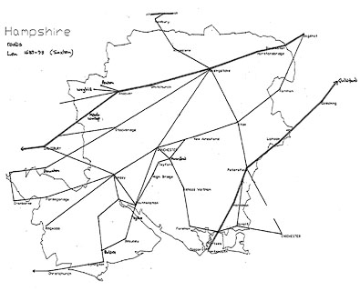
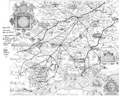
An interesting addition to the map is roads, drawn by double or single lines. This is one of the early road maps of Hampshire.
Two main routes are shown:-
London to Lands End; from Bagshot, Surrey; through Blackwater, across Herfordbridg, then Hertleyrow, Newneham, BASINGSTOKE, Wotton, Malshanger, Polhampton, Laverstoke, Whitchurche, Hurseborn, ANDOVER, Midle Wallop, Hampshire; to SARUM, Wiltshire; and westward.
London to Portsmouth; from GYLFORDE, through GODALMYNGE, and Thursley, Surrey; fown the Hampshire Sussex border through Lippock, to PETERSFELDE, then Heat house, Harnden, across Portes bridge, through Kings T[own], to PORTESMOUTH, Hampshire.There is a whole network of minor roads, which do not copy the 'Ogilby' routes. Ogilby plates 25, 26, 30, 32, 51, 53, 81, and 97 are matched, perhaps not exactly; but not Ogilby plates 39 or 83; and there are a lot of other roads.


Hundred boundaries are drawn by fine dotted lines (the county boundary on the original made bolder to be different). The areas are labelled, eg:-
BUDDLESGATE HUN:
Part of Odiam hun:
Bosmere & Halyng hunHundred names are listed below. I have not attempted to check the boundaries and names in detail. The hundred names are tucked in between other matter on the map, usually broken up, sometimes badly dissociated. They are mostly in italic block caps and in a different hand, but it is not easy to pick them out, there may be errors! In some instances the spellings below are an amalgam of labels, and have been tidied up a little.
Alton Hundred
Andover Hundred
Barmanspit Hundred
Barton Stacy Hundred
Basingstoke Hundred (also ...stock)
Bosmere and Halyng Hundred
Buddlesgate Hundred
Buntesboro Hundred
Chuteley Hundred
Crundall Hundred
East Meon Hundred
Evinger Hundred
Extra Hundred (ie Andover Extra)
Fawley Hundred
Finchdeane Hundred
Fordingbridg Hundred
Hambledon Hundred
Holdshot Hundred
Horwell Hundred
Kings Somborne Hundred
Kingscler Hundred
Mansbridge Hundred
Meanestoke Hundred
Mychelldeavour Hundred
New Forrest Hundred
Odiham Hundred
Pastrae Hundred
Portsdowne Hundred
Redbridg Hundred
Ringwood Hundred
Selbourne Hundred
Sutton Hundred
Thorngate Hundred
Titchfield Hundred
Waltham Hundred
Wherwell HundredWhile there are some similarities the hundreds are not a simple copy from Speed. Shapes and spellings differ. I do not propose to study these in detail.

Winchester

AndoverSome settlements have an added symbol for their status; cross (+) for Market Town, crown for Parliamentary Borough, mitre for a bishopric. Some antiquarian data is added, place names etc, and is noted here.
Checking the places is laborious! but rewarding, there are many added villages (V) and hamlets (H), etc.
NB - THIS CHECK HAS BEEN DONE ONCE, AND NOT CHECKED.
[Broxson] [H]
Bramsholt [H]
Coldree [H]
Lippock [H]
Milcourt [H]
Westcourt [V]and:-
Alton has an added cross (+)
Andover has added crown and cross (+)
Hundred
Saveston [V]
Hundred
Basingstoke has an added cross (+)
Hundred
No: wood [H]
Southwood [H]
Warblington [V]
Hundred
Grange [H]
Hundred
Allom house
Boscomb capperas house
Burton [H]
Holmhurst cha:
Iford [V]
Nash [H]
Parlieu [H]
Preston [V]
Somerford [H]
Sopley [V, south of Avon]
Tuddiford [H]
Winton [H north of Avon]and:-
Christchurch added 'crown'
Hilhouse [H]
N: Okeley [H]
Bramshot [H]
Burycourt [H]
Crookham
Fernboro [V]
Haly [H]
Itchell [V]
Linchford [V]
Shaphoue [H]
Combe [H]
Oxenburns [H]
Ramsden [H]
Riplington [H]
Sheete [H]
Bindley [H]
Egbury [H]
Frifalk
Henley [H]
Stoke [H]
Swamton [Yyke] [H]and:-
Iclere has an added letter to its misspelled name, now:-
HIclere
Whitchurch has added crown and cross (+)
Crowdhill [H]
Lovington [H]
Tertio Deane [H[
Winchester has added crown, ?cross (+), mitre, and added label:-
ant: Venta Belgarum
Harn~den [H]
Heat house
Mapledurha~ [H]and:-
Petersfield has an added crown and ?cross (+)
Hundred
Beckham [H]
Fordingbridg [V]
Setchfield [H]An old addition is replaced by
Burgate [V]and:-
Charford has added label:-
Cerdicksford
Hundred
Brashel [H]
Minley [H]and:-
Sylchester has added labels:-
Caer Segonte / VindonumAn area here, Pamber Forest, is now labelled:-
THE SEGONTIANS
Charcott [H]
Hundred
Rumsey has added cross (+)
Clerewoodcott [H]
Earlston [H]and:-
Kingsclere has an added cross (+)
Hundred
Berfeld
Eastely [H]
Wulston [H]
Hundred
Oxenbury [H]
Peake [H]
Preshowe [H]
Westbury [H]
Hundred
Borocate [H]
W: Stratton [H]
Weston [H]
Badsley [H]
Batramsley [H]
[Billey] [H]
Fritham [H]
[Gyms] [H]
Hobury [H]
Lymwood
Malwood ca: [castle]
Roydon [H]and:-
Lymington has an added 'crown'
Wintney [V]and:-
Odiam has an added cross (+)
Bullington [H]
Polhampton [H]
Tustonand:-
An existing symbol has label added:-
Southampton
Harwood [H]
Hundred
Bearhouse [H]
Catcomb [H]
Kings T [H]
Polsgrave [H]
Wansted [H]and:-
Portsmouth has added crown and cross (+)
Moorcott [house]
Tachbury [H]
Testwood [V]
Totton
Moyles courtand:-
Ringwood has an added 'cross' (+), and added label:-
Regnum
Newton has an added crown (surely an error!)
Alresford has an added cross (+)
Midle Wallop [H]
Cams [H]
Crofton chapell
Lee Markes [H]
Rochcourt [H]
Rowner [V]and:-
Lee is changed to:-
Leebritayne
Titchfield has an added cross (+)
Cowdridg [H]
St Maryes [H]and:-
Bishops Waltham has added cross (+)
Southampton has added crown and cross (+) and added label:-
Clausentum
Summary of Town Differentiation
| town | map name | features | ||
| Alton | Alton | market | ||
| Andover | Andover | market, borough | ||
| Basingstoke | Basingstoke | market | ||
| Bishops Waltham | Bishops Waltham | market | ||
| Christchurch | Christ Church | borough | ||
| Fareham | Faram | market | ||
| Fordingbirdge | Fordingbridg | market | ||
| Gosport | Gosport | |||
| Havant | Havant | market | ||
| Kingsclere | Kingesclere | market | ||
| Lymington | Lemyngton | market, borough | ||
| New Alresford | Alresford | market | ||
| Odiham | Odiam | market | ||
| Petersfield | Petersfelde | market, borough | ||
| Portsmouth | Portesmouth | market, borough | ||
| Ringwood | Ringwood | market | ||
| Romsey | Rumsey | market | ||
| Southampton | Southampton | market, borough | ||
| Stockbridge | Stockbridge | market, borough | ||
| Whitchurch | Whitchurche | market, borough | ||
| Winchester | Winchester | market, borough, bishopric | ||
| Newtown nr Selborne | Newton | borough (!!) |


Published in 'The Shires of England and Wales Described by Christopher Saxton Being the Best and Original Mapps With many Additions and Corrections Viz: ye Hundds, Roads, &c. by Philip Lea. Also the new Surveis of Ogilby, Seller, &c. Sold by Phillip Lea ...' about 1693.
Published in a french edition 'Atlas Anglois contenant Les Cartes Nouvelles tres Exactes Des provinces, Duches, Comtes, & Baronies du Royaume d'Angleterre. Le tout Enrichi des Plans des Villes & des Armes de la Noblesse. London, Par P. Lea.' about 1693.
Published in 'The Shires Of England And Wales Described by Christopher Saxton Being the Best and Original Mapps With many Additions and Corrections Viz: ye Hundds, Roads. &c. by Philip Lea Also the New Surveis of Ogilby. Seller. &c. ... Sold by Geo: Willdey at the Great Toy, Spectacle, China-ware, and print Shop, the Corner of Ludgate Street near St. Pauls London.' about 1732.
Published in 'The Shires of England And Wales ... Sold by Thomas Jeffreys, Geographer to His Royal Highness the Prince of Wales; in Red Lyon Street near St. John's Gate. ...' about 1749
Published in an atlas and as a loose sheet by Cluer Dicey and Co, London, about 1772


