 Map Group MURRAY 1830


Published in 'An Atlas of the English Counties divided into Hundreds &c., containing the Rivers, Roads, Parks, Parishes, &c. in each, Exhibiting the whole of the Inland Navigation, Rail Roads, &c., And accompanied by Maps of England, Ireland, Scotland and Wales, Projected on the basis of the Trigonometrical Survey By Order of the Honble. The Board of Ordnance. Under the Superintendence of T. L. Murray.' 1830.


map maker
publisher
engraver

HAMPSHIREand at the bottom:-
Drawn under the Superintendence of T. L. Murray. / London, Published May, 1st. 1830, by T. L. Murray, 19 Adam Street, Adelphi / Hoare & Reeves Sc.
compass rose

Printed on the left above centre is a compass rose; no circle, star points for cardinal and half cardinal directions, North marked by a fleur de lys. The map is printed with North at the top of the sheet.
scale

SCALEchequered in miles, labelled at 1..5, 10,15 miles. The 15 miles = 85.4 mm gives a scale 1 to 282672 assuming a statute mile. The map scale is about:-
1 to 280000
4.5 miles to 1 inchThe scale can also be estimated from the latitude scale, 1 degree latitude = 397mm gives a scale 1 to 280399. The map scale is about:-
1 to 280000
The ratio of lat/long scales is 1.59 which makes a 'square' map at 51 degree N.
The bottom Longitude scale is labelled:-

Longitude West from Greenwich.As well as can be read the:-
longitude, Winchester = 1d 17.7m W(The accepted value, now, is 1d 18.5m W.)
The map includes from 0d 40m to 2d 0m W, 50d 27m to 51d 33m N; Hampshire including the Christchurch area now Dorset, and the Isle of Wight.
EXPLANATION
Market Towns with the Distance from London in Measured Miles as ... ... WINCHESTER 63
Churches & Chapels ... ... [cross (+)]
Turnpike Roads [double line, light bold] Mail Roads [double line plus a line, light bold, down the middle]
Bye Roads ... ... [double line, light light, narrower]
Rivers ... ... [wiggly line]
Navigable Canals ... ... [triple line, light bold light]
Parks & Gentlemens Seats ... ... [outline, pecked interior, fence palings]
NB. The figures on the Turnpike Roads shew the distance in Measured Miles between one Market Town and another
The stars prefixed to the Towns denote the number of Members return'd to Parliament
sea shaded

The sea area is partly shaded, an extension of the coast shading. Some sea areas are labelled, eg:-
ENGLISH CHANNEL
THE SOLENT
Christchurch Bay
SPITHEADand some of the channels, eg:-
Nth. Channel
Sth. Channelat the western approach to the Solent, by the Needles.
coast shaded
headlands
harbours

The coast line is shade.
Some headlands are labelled, eg:-
Needs Ore Pt.
Hengistbury Hd.Some channels in harbours are marked by a foreshore line, for instance in Southampton Water, and the harbours of Portsmouth, Langstone and Chichester.
Portsmouth Harb.
Chichester Harbourare labelled.
fortifications

Coastal defences are not noticed. The only element shown is a thin angular line around the naval dockyard at Portsmouth, which could be interpreted as fortifications.
ponds
bridges
ferries

Rivers are drawn by a wiggly line tapering inland. An estuary has shading continued from the coast, for examples the Hamble and Itchen. Wider rivers are drawn with a double line plus form lines, for example the Avon up to Ringwood. Braiding might be indicated. Not all rivers are labelled, but see:-
Avon R. [by Lymington]
Test R.
Beaulieu Riv.Most of the main river systems are shown, with some tributaries. Without a detail study I feel that some rivers are not dealt with as well as others - the upper parts of the Itchen, the Rother, and where is the Wallop?
Bridges are not particularly noticed; they are implied where a road crosses and interrupts a river. They are not much labelled, but see:-
Bridgeover the Test near Uphill; and on the Hart:-
Hartford Br
Bakers BrElsewhere, at Hamble for example, roads either side of a river suggest (no more) a ferry.
A few ponds are drawn in outline with form lines, perhaps labelled, eg:-
Fleet Pond
Woolmer Pond
hill hachuring

Relief is indicated by hill hachuring, which gets lost amongst the other stuff of the map, and adds its own degree of confusion. Hills are not labelled generally, but some are implied by settlement names, eg:-
Rose Hill Pla.
Filmer Hill
Swain's Hillnone of which are near any hachures.
Quarley Hillis clearly labelled, but the hachures do not show a detached hill top.
Beaconto the north of Exton, ie Exton Beacon.
forests
trees

Woodland is shown by groups of tree and bush symbols, with undergrowth. Some areas are labelled, eg:-
Daily Wood [Doyle's??]
Alice Holt Wd.
Otterwood
Beer Forest [East Bere Forest]

Parks are drawn in outline; the interior pecked, perhaps with a block for a house, and fence palings. Some are labelled by name or by the name of a house, eg:-
Bolderwood Lo.
Cadland Pa.
Highclere Park
Clare H.The interior is tinted green on this copy of the map.

The count boundary is a bold dotted line. Adjacent counties are labelled, eg:-
SUSSEXThe detached part of Hampshire in Sussex is not shown, but the two detached parts of Wiltshire on the county's northern border are drawn and labelled. A very few places outside the county are included for the sake of road continuity; Ludgershal, Newbury, and Farnham.
table of hundreds

Hundred boundaries are light dotted lines, tinted for emphasis on this copy of the map. Hundred areas are labelled with a large number which keys to a table of hundreds printed lower left:-
REFERENCE to the HUNDREDS
Andover ... ... 1
Alton ... ... 2
...
Wherwell Forest ... 40The 40 hundreds include 2 on the Isle of Wight.
distances from London
town

WHITCHURCH / 57 [2 stars]
WINCHESTER / 63
STOCKBRIDGE / 66 [2 stars]The distance from London is given with the town name.

Chawton
Ibbesley
Cheriton

Oakhanger
LipscombThis style of lettering is used generally for labelling features, for instance farms and houses.
There seems to be a hamlet called:-
Cabbage Patchnorth of Shalden, what?

Basingstoke C.
Andover C.
Southampton Canal

Rising Sun [N of Bashley]
Queen Charle. Inn [E of Andover]
Lion Inn [S of Basingstoke]

Race Coursea dotted oval.
tumuli
Crawley Barrow
Brick Kilns
Decoy
Monumentwhich is the Nelson Monument. And monument another on the hills north of Farley.


turnpike roads
post roads
road distances
Roads are differentiated as described in the table of symbols:-

Turnpike roads have one line bold; this convention is continued if dotted.

On the turnpike outside Basingstoke is the:-
Dean Gate Innwhich suggests a turnpike gate there. But beware, there is a hamlet called Hatch Gate, near Steventon, nowhere near a turnpike. Not all gates are turnpike gates.
Post roads have an extra light continuous line down the middle.
Some roads destinations outside the county are labelled, eg:-
To Staines 14Ms
From Wimborne 6 MilesRoad distances are given along turnpiked roads by a series of figures at mile intervals. For example the road from Petersfield north east is labelled 1, 2, 3 ... 6 towards Liphook; and the same road from Petersfield is number 5 .. 16 to Portsmouth. This labelling is a rather hit and miss.
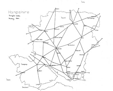
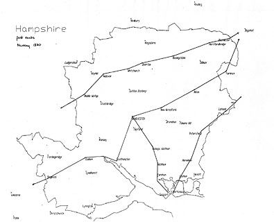
Most of the obvious main routes appear to have been turnpiked. A few are not, examples: Petersfield to Midhurst, though this could be regarded as a branch route; and Christchurch to Lymington. The obvious source of comparison to check this map is Day's map published with a Parliamentary Report, 1852:-


[from London]; through Staines, Middlesex; [Bagshot, Surrey]; then Blackwater, Hartfordbridge, Basingstoke, Overton, Whitchurch, Andover, Middle Wallop, Hampshire; [on to Salisbury, Wiltshire ...]
[from London]; through Staines, Middlesex; [Bagshot] and Farnham, Surrey; then Alton, New Alresford, Winchester, Southampton, Hampshire AND on from Southampton through Redbridge, to Ringwood, Hampshire; and to Wimborne, Dorset.
from Winchester, through Bishops Waltham, Wickham, Fareham, to Gosport, Hampshire.
[from London; through Godalming, Surrey]; then Liphook, Petersfield, Horndean, Cosham, to Portsmouth, Hampshire.


