 Map Group PIGOT 1828


map maker
engraver

HAMPSHIRE.Printed bottom centre:-
Published by Pigot & Co. 17 Basing Lane London & 18 Fountain St. Manchester.
Engraved on steel by Pigot & Son ManchesterPrinted bottom right:-
WINCHESTER CATHEDRAL.
compass rose
up is N

Printed upper centre is a compass rose; no circle, star points for cardinal and half cardinal directions, North marked by a fleur de lys. The map is printed with North at the top of the sheet.
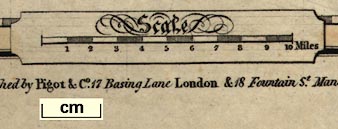
scale

Scalechequered and labelled in miles, the 10 miles = 42.1mm gives a scale 1 to 382267 assuming a statute mile. The map scale is about:-
1 to 380000
6 miles to 1 inchAnother estimate of scale can be made from town positions, comparing known town-town distances, using DISTAB.exe. The map scale is about:-
1 to 400000
6.5 miles to 1 inch

Latitude and longitude scales are printed in the borders for a trapezoid projection; chequered at minutes, marked at 5 minute intervals. The map includes form 0d 42m to 1d 53m W, from 50d 28m to 51d 39m N; the whole of Hampshire including the Christchurch area of Dorset, and the Isle of Wight.

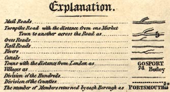
Explanation.
Mail Roads ... [double line + dotted line down centre]
Turnpike Road with the distance from one Market Town to another across the Road as .. [double line, light bold, and figure]
Cross Roads ... [narrow double line]
Rail Roads ... [bold line with cross ties]
Rivers ... [wiggly line]
Canals ... [triple line, light bold light]
Towns with the distance from London as ... GOSPORT / 74
Villages as ... Botley
Division of Hundreds ... [dotted line]
Divisio of the Counties ... [bold dotted line]
The number of Members returned by each Borough as PORTSMOUTH [2 stars]This includes railways - even though this map shows no railways.
sea plain
sandbanks
SOUTHAMPTON WATER
THE SOLENT
SPITHEAD
THE ENGLISH CHANNEL
Stokes BayOutlines of sandbanks are shown by a dotted line in the sea mostly between the Isle of Wight and the mainland. These might be labelled, eg:-

Horse Sand
coast form lines
harbours
sea marks
headlands

The coast line is emphasised by form lines extending some way out to sea and into harbours and river mouths.
Harbours are clearly shown. The form lines continue into the harbours, and main channels are also indicated. Some harbours are labelled, eg:-
PORTSMOUTH HARBOUROn the channel of the Lymington River there is a ?post labelled:-
A 'Beacon' and something labelled:-
Beaconand a further post with a ?cross bar, labelled:-

Jack in the BasketSome headlands and are labelled, eg:-
Needs Ore Point
castles
fortifications

Hurst Cas
Netley Cas
Calshot Cas
Cumberland FtAlthough not a clear representation of polygonal artillery fortification, the works protecting Portsmouth and the naval base at Portsea can be seen on the map:-

ponds
bridges

Riv Wey
Avon RiverDrawn in putline near Farnborough is:-

Fleet PondThe lake in Stratfield Park is shown; some other large ponds and lakes are not.
Bridges are implied by a road crossing a river, rather than shown by a symbol.
Quarley Hill
forests
vegetation

Forest of Bere
Dole Wood
Alice Holt WoodTracks across such areas might be indicated as unfenced roads.

Highclere
Rotherfield PaAnd the confusion between park and settlement might be clarified as:-
Herriard & Pa

The county boundary is shown by a bold dotted line crudely tinted yellow. Contiguous counties might be labelled, eg:-
WINCHESTERThe adjacent county each have a tint along the boundary: Dorset pink; Wiltshire green, its detached parts in Berkshire are not shown; Berkshire pink, as is its detached part in Wiltshire; Surrey blue; Sussex pink. The detached part of Hampshire in Sussex is shown and labelled:-
P. OF HANTS.BUT this label's engraving is back to front, ie the engraver forgot to engrave it backwards.
Roads and settlements are shown in the adjacent counties for the sake of continuity.
table of hundreds

Hundred boundaries are shown by a light dotted line. The areas are keyed to a table of hundreds by number, except the part areas which are labelled explicitly, eg:-
PART of OVERTON
distances from London
electoral data

WINCHESTER / 64 [2 stars]The stars denote the number of members returned to Parliament. The figure is the distance from London.

ALTON / 47

East Worldham

Middle WallopThe block and italic label are used for all sorts of other features.
road distances
post roads
turnpike roads

Roads are drawn by a double line, solid or dotted presuamble indicating fenced and unfenced. Roads are differentitaed by breadth. The broader roads are turnpike roads and have one line bold; post roads have an extra dotted line down the middle:-

Distances from town to town are given by a figure across the road.

Basingstoke Ca.
Southampton Canal
Arundel Canal

Race Cou. [Worthy Down]
Stockbridge Race Gr
Gunner Cas
Owls Castle
Ship Ydjust south of Beaulieu.


PIGOT / & COS. / British / ATLAS / OF / THE COUNTIES OF ENGLAND, / WITH / A map of England and Wales, / A CIRCULAR ONE OF THE COUNTRY ROUND LONDON, / TO THE DISTANCE OF FOURTEEN MIILES; / THE WHOLE ENGRAVED ON STEEL PLATES, / AND / EMBELLEISHED WITH A CORRECT GRAPHIC SERIES OF VIGNETTES / OF THE / Cathedrals and some of the handsomest Churches in England: / ACCOMPANIED BY / TOPOGRAPHICAL ACCOUNTS, EXHIBITING THE GENERAL STATISTICS OF EACH COUNTY; ITS ANCIENT / HISTORY, AND MODERN LOCALITIES AND DIVISIONS; / COMMERCE, MANUFACTURES, AND POPULATION; TABLES OF DISTANCES, &c. / THE ENTIRE PREFIXED BY / COMPREHENSIVE RECIPROCAL DISTANCE TABLES, / OF THE / PRINCIPAL TOWNS IN GREAT BRITAIN, &c. / AND AN ITINERARY OF THE MOST USEFUL AND GENERALLY TRAVELLED / MAIL AND COACH ROUTES / THROUGHOUT THE UNITED KINGDOM. / PUBLISHED BY J. PIGOT & CO. BASING-LANE, LONDON, AND FOUNTAIN-STREET, MANCHESTER: / And sold by them and the following Booksellers:- / SIMPKIN AND MARSHALL, STATIONER'S COURT, LUDGATE HILL; SHERWOOD AND CO. PATERNOSTER ROW; WINCHESTER AND VARNHAM, 61, STRAND; ; EFFINGHAM WILSON AND JOHN RICHARDSON, ROYAL EXCHANGE; HATCHARD AND SON, PICCADILLY; AND BY ALL RESPECTABLE BOOKSELLERS / IN THE KINGDOM. / Price, with Coloured maps, neatly made up in boards .... 2 10 0 / Extra Coloured, and the \maps mounted on Cloth .... 4 0 0 / Ditto Ditto elegently bound, and gilt .... 4 10 0 / 1831
Published in another edition '... Published by J. Pigot & Co. 59, Fleet Street, London ...' 1839.
Published in another edition 1840.
Published in another edition 'Pigot & Co.' British Atlas ... I. Slater, Printer, Fountain Street, Manchester.' 1844.
Published in another edition 'I. Slater's new british Atlas ... Published by Isaac Slater (late Pigot & Slater), Fleet Street, London; Fountain Street, and Portland Street, Manchester: and sold by him and the following booksellers: Simpkin, Marshall & Co., etc.' 1857-58.


