Research Notes


Map Group RAMSAY 1866

Ramsay 1866
Geological Map of England and Wales, scale about 12 miles to 1 inch, by Andrew C Ramsay, Director of the Geological Survey, published by Edward Stanford, Charing Cross, London, 1866.


These notes are taken from Ramsay's Geological Map of England and Wales, third edition, 1866, in the Map Collection of Hampshire CC Museums Service, item HMCMS:FA1997.72.
The map is colour printed.
The map size is: wxh, sheet = 85.5x101cm; wxh, map = 809x942mm, including the gaps where the map has been sectioned for folding, and mounted.
 
MAP FEATURES - including sections
GEOLOGICAL SERIES
HAMPSHIRE TOWNS
ITEMS in the Collection

MAP FEATURES - including sections
Detail notes are mostly taken from the Hampshire area.
title    
map maker    
publisher    

Printed top right:-
image snip from map
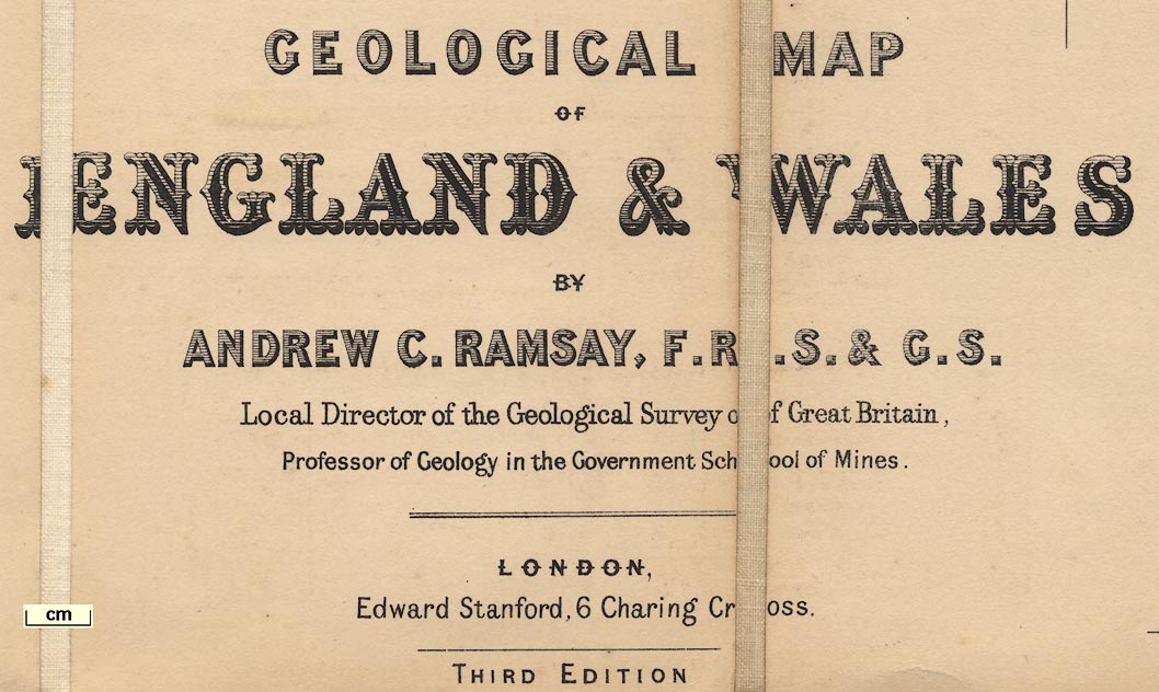
GEOLOGICAL MAP OF ENGLAND & WALES BY ANDREW C. RAMSAY, F.R.S.& G.S. Local Director of the Geological Survey of Great Britain, Professor of Geology in the Government School of Mines. LONDON, Edward Stanford, 6 Charing Cross. THIRD EDITION
Printed bottom centre:-
London; Published by Edward Stanford, 6 Charing Cross, January 15th. 1866
and bottom right:-
Stanford's Geographical Establishment, London 1866.

orientation    
up is N    

The map's orientation is indicated only by the latitude and longitude scales and grid. The map is printed with North at the top of the sheet.

scale line    
scale    

Printed on the right below the title etc is a:-
SCALE
divided and labelled at 10 mile intervals. The 30 miles = 62.5 mm giving a scale 1 to 772485 assuming a statute mile. The map scale is about:-
1 to 770000
12 miles to 1 inch

lat and long scales    
lat and long grid    

Printed in the map borders are scales of latitude and longitude for a type of conical projection; chequered at 10 minute intervals and labelled at degrees.
The map includes from 2d E to 6d W, from 50d to 55d 40m N; the whole of England and Wales, with the Isle of Man, with an outline of parts of Scotland and the coast of France.

sea area    
sea plain    

The sea area is plain; some ares are labelled, eg:-
The Solent
Stokes Bay
Southampton Water

coast line    
coast shaded    
headlands    
lighthouses    

image snip from map
The coast line is emphasised by shading on the inland side. A few headland are noticed, eg:-
Hengistbury Head
and some lighthouses, eg:-
Light [at Hurst]
Needles Light

rivers    
Some rivers are drawn by a wiggly line, perhaps labelled, eg:-
Anton [River Test]
Itching R

relief    
hill hachuring    

image snip from map
Some relief is indicated by hill hachuring.

woods    
Some woodland is indicated by tree symbols.

parks    
Some parks are drawn in outline, perhaps labelled, eg:-
Hackwood Park

county    
image snip from map
County boundaries are fine dotted lines. the county areas are labelled, eg:-
HANTS

settlements    
Settlements are marked by a circle, or a group of blocks for larger places, perhaps a cross for a village church, and labelled, eg:-
WINCHESTER
Basingstoke
Old Alresford

roads    
A network of main roads is drawn by double lines, and some minor roads by single lines.

railways    
Railways are drawn by a line with cross lines.

geology    
fossils    
geological sections    

Areas of ?solid geology are bounded by a solid line, coloured distinctively, and labelled with a number in a shadowed rectangle. The number refers to the table of strata.
image snip from map
In crude terms the north part of Hampshire is mostly Cretaceous, 21 Chalk; the south Eocene, 23 Bracklesham and Bagshot Beds and 24 Fluvio Marine.
The map has comments about palaeontology, what fossils might be found, along the coast line. For example, in the Hampshire area:-
EOCENE FOSSILS
is marked at Christchurch Bay, and offshore:-
ALTERNATING BEDS OF FRESHWATER & MARINE SHELLS / WITH MAMMALIAN REMAINS / MARSUPA & REPTILES / NEW FOREST & COAST CLIFFS / CAPPED WITH FLINT GRAVEL
The comments includes notes about drift, caverns, etc.

In spare areas around the map, ie in the sea areas, there geological sections, for example:-
image snip from map
No.3 Section across the Isle of Wight from Hempsted Hill to Brixton Bay. Horizontal Scale 1 inch to a mile
Other sections might have a different horizontal scale; no vertical scale is given, but it is exaggerated. Sections are coloured and labelled with the rock names and numbers referring to the table of strata. On the map, the line of each section is drawn and numbered.

  top of page

GEOLOGICAL SERIES
table of strata    
Printed on the right below the title is an:-
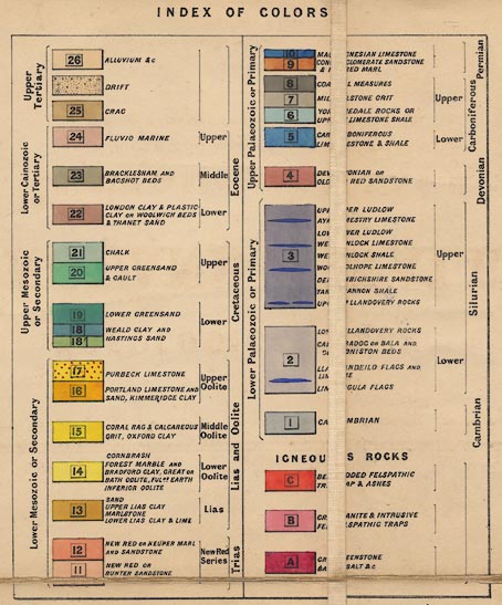
INDEX OF COLOURS
from the alluviums of the upper Tertiary down to Cambrian strata. Each rock is identified by colour, perhaps with dotting or other engraving pattern, and a number. The stratum is labelled with one or more rock terms and is grouped into geological era, period, etc. For example the:-
Lower Mesozoic or secondary
image snip from map
includes number 15, labelled:-
CORAL RAG & CALCAREOUS GRIT, OXFORD CLAY
in the:-
Middle Oolite
Lias and Oolite
image snip from map
numbers 17 and 16.
Below the sedimentary rocks are the:-
IGNEOUS ROCKS
labelled C, B, and A. For example B is:-
GRANITE & INTRUSIVE FELSPATHIC TRAPS
and a declaration that:-
The corresponding numbers are on the Map & Sections. Faults in Sections marked [italic] F. Inclination of Strata [arrow]

The geological series on the map, working from the table of strata, appears to include:-

   [Tertiary]
     Upper Tertiary
       [ ]
         [ ]
           Alluvium, etc - no.26
           Drift - no number
           Crag - no.25
     Lower Cainozoic or Tertiary
       Eocene
         Upper [Eocene]
           Fluvio Marine - no.24
         Middle [Eocene]
           Bracklesham and Bagshot Beds - no.23
         Lower [Eocene]
           London Clay & Plastic Clay or Woolwich Beds & Thanet Sand - no.22
   [Secondary or Mesozoic]
     Upper Mesozoic or Secondary
       Cretaceous
         Upper [Cretaceous]
           Chalk - no.21
           Upper Greensand & Gault - no.20
         Lower [Cretaceous]
           Lower Greensand - no.19
           Weald Clay; and Hastings Sand - no.18
     Lower Mesozoic or Secondary
       Lias and Oolite
         Upper Oolite
           Purbeck Limestone - no.17
           Portland Limestone and Sand, Kimmeridge Clay - no.16
         Middle Oolite
           Coral Rag & Calcareous Grit, Oxford Clay - no.15
         Lower Oolite
           Cornbrash; Forest Marble and Bradford Clay, Great or Bath Oolite, Fullers Earth; Inferior Oolite - no.14
         Lias
           Sand; Upper Lias Clay; Marlstone; Lower Lias Clay & Lime - no.13
       Trias
         New Red Series
           New Red or Keuper Marl and Sandstone - no.12
           New Red or Bunter Sandstone - no.11
   [Primary or Palaeozoic]
     Upper Palaeozoic or Primary
       Permian
         [ ]
           Magnesian Limestone; Conglomerate Sandstone & Red Marl - no.10 & no.9
       Carboniferous
         Upper [Carboniferous]
           Coal Measures - no.8
           Millstone Grit - no.7
           Yoredale Rocks or Upper Limestone Shale - no.6
         Lower [Carboniferous]
           Carboniferous Limestone & Shale - no.5
       Devonian
         [ ]
           Devonian or Old red Sandstone - no.4
     Lower Palaeozoic or Primary
       Silurian
         Upper [Silurian]
           Upper Ludlow; Aymestry Limestone; Lower Ludlow; Wenlock Limestone; Wenlock Shale; Woolhope Limestone; Denbighshire Sandstone; Tarannon Shale; Upper Llandovery Rocks - no.3
         Lower [Silurian]
           Lower Llandovery Rocks; Caradoc or Bala and Coniston Beds; Llandeilo Flags and Lime; Lingula Flags - no.2
       Cambrian
         [ ]
           Cambrian - no.1

   Igneous Rocks
           Bedded Felspathic Trap & Ashes - letter.C
           Granite & Intrusive Felspathic Traps - letter.B
           Greenstone; Basalt & c - letter.A

Printed below the table of strata is a list of:-
AUTHORITIES CONSULTED
Published Maps of the Geological Survey of Gt. Britain, from Wales, Middle & S.W. of England &c.
N. & N.E. of England, Professor Phillips, F.R.S.
Cumberland, Westmorland &c. Professor Sedgwick, F.R.S. & Mr. Ruthven
Permian Rocks, North of Cheshire & The Humber, Professor Sedgwick, F.R.S. Sir R. I. Murchison & Mr. E. W. Binney.
The Neighbourhood of London, Mr. Joseph Prestwich, F.R.S. & Mr. Mylne.
Greenough's Geological Map of England; Phillip's ditto.
Dr. Fitton, Strata below the Chalk.
Isle of Man, Revd. J. G. Cumming.
 
  top of page

HAMPSHIRE TOWNS
The '21' market towns of Hampshire are included:-
Alton
Andover
Basingstoke
Bishops Waltham
Christ Church
Fareham
Fordingbridge
Gosport
Havant
Kingsclere
Lymington
Alresford
Odiham
Petersfield
Portsmouth
Ringwood
Romsey
Southampton
Stockbridge
Whitchurch
Winchester
  top of page

ITEMS  in HMCMS Map Collection   (scanned item in bold)
  HMCMS:FA1997.72 -- geological map
  top of page

   All Old Hampshire Mapped Resources