
 Map Group TAYLOR 1759



1 2
3 4
5 6


... an accurate survey ...
... sufficiently exact ... for common purposes ... extremely defective with respect to the topographical representation of the ground ...
Mr Faden bot [ye] plates wch. he finds require a new survey before they can be republished.


The Society for the Encouragement of Arts, Manufactures and Commerce
Royal Society of Arts
I would submit to you as a Friend whether the State of British Geography be not very low, and at present wholly destitute of any public encouragement. Our maps of England and its counties are extremely defective ... if among your premiums for Drawings some reward were offered for the best Plan, Measurement and Actual Survey of City or District, it might move the Attention of the Public towards Geography, and in time, perhaps, incline the Administration to take this matter into their Hands (as I am informed it does in some foreign Countries) and employ proper Persons every year, from actual Surveys, to make accurate Maps of Districts, till the whole island is regularly surveyed.
... to give a sum not exceeding one hundred Pounds, as a Gratuity to any Person or Persons, who shall make an accurate Survey of any County upon the Scale of one Inch to a Mile ...Sea coasts were to be to be accurately drawn with latitudes and longitudes and satisfactory proofs of accuracy required ...
if any Person or Persons do propose to make such a Survey they are desired to signify their particular intentions on or before ye 2nd Wednesday in November next
an accurate trigonometrical survey ... the horizontal distances of all places in the map to be taken with the theodolite or plain table and the roads to be measured witha Perambulator and noted won in figures; the courses and bearings of all the principal rivers to be correctly taken ... the sea coasts of all the maritime counties accurately laid down together with their latitudes and longitudes ...
Theodolite or Plain Table ... was to guard against taking the angles by the circumferentor or such uncertain instruments, ...
THESE County Maps are sufficiently exact, in what regards their geometrical measurement, for common purposes, but are extremely defective with respect to the topographical representation of the ground, giving scarcely any Idea, or at least but an imperfect one, of what is remarkably strong or weak in the nature of the Country.
Ravenhill, W L D: 1965: Benjamin Donn, a Map of the County of Devon (introduction): Devon and Cornwall Record Society & University of Exeter


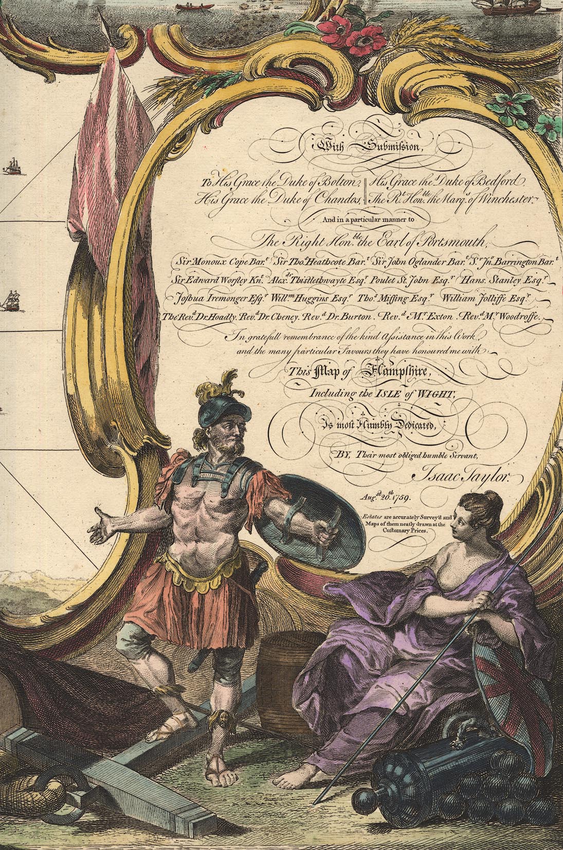
scroll cartouche
dedication
map maker

At the lower right of sheet 6 is a scroll cartouche with dedications, title, etc:-
With Submission / TO His Grace the Duke of Bolton, His Grace the Duke of Bedford, /His Grace the Duke of Chandos, The Rt. Honble. the Marqs. of Winchester. / And in particular manner to / The Right Honble. the Earl of Portsmouth, / Sir Monoux Cope Bart. Sir Thos. Heathcote Bart. Sir John Oglander Bart. Sr. Jno. Barrington Bart. / Sir Edward Worsley Knt. Alexdr. Thistlethwaite Esqr. Poulet St. John Esqr. Hans. Stanley Esqr. / Joshua Iremonger Esqr. Willm. Huggins Esqr. Thos. Missing Esqr. William Jolliffe Esqr. / The Revd. Dr. Hoadley. Revd. Dr. Cheney. Revd. Dr. Burton. Revd. Mr. Exton. Revd. Mr. Woodroffe. / In grateful remembrance of the kind Assistance in this Work / and the many particular Favours they have honoured me with, / This Map of Hampshire, / Including the ISLE of WIGHT, / Is most Humbly Dedicated / BY, Their most obliged humble Servant, / Isaac Taylor. / Augst. 20th. 1759. / Estate are accurately Survey'd and / Maps of them neatly drawn at the / customary Prices.The cartouche includes drawings of a warrior and a maiden in classical dress; there are a cannon and cannonballs as well as spears and shields, an anchor, and ships in a harbour scene where the town has artillery style fortifications.
R Benning Sculp
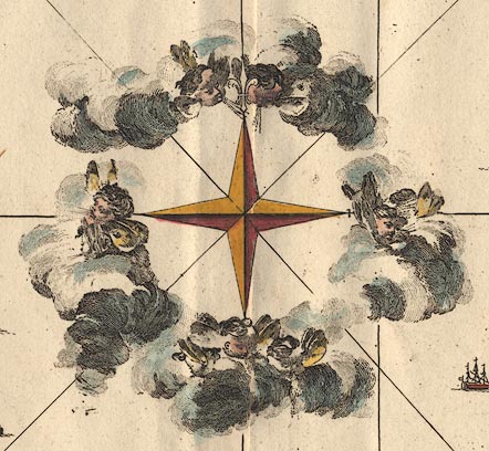
compass rose
Around the compass rose are winged cherubs blowing airs from the clouds:-
lat and long grid

In the borders of the sheets there are rectangular latitude and longitude scales; chequered at minutes, latitude labelled at 4 minute intervals, longitude at 5 minute intervals. A lat and long grid is drawn on the map with 5x4 minute cells.
The map covers 0d 28m W to 1d 44m W, 50d 33m N to 51d 29m N, according to the map's scales; there is no statement of the prime meridian. Winchester is plotted at about 1d 8 1/2m W 51d 3 1/4m N putting his prime meridian 10 degrees W of Greenwich (this is not St Paul's; it could be Westminster Abbey or the Houses of Parliament, or?).
The scales have 1 degree longitude = 1286 mm, 1 degree latitude = 1701 mm. Assuming 1 degree lat = 69.17 miles this provides an estimate of the map scale, 1 to 65443, ie about:-
1 to 65000
scale
chain
simple theodolite
theodolite
dividers
globe

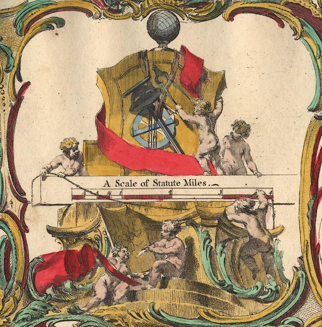
A Scale of Statute MilesThis has 4 miles, chequered in miles and the first mile in quarters. 4 miles = 101.1 mm giving a map scale 1 to 63673, ie the scale is about:-
1 to 64000
1 mile to 1 inchBy measuring the positions of a number of towns it is possible to estimate the maps scale by comparing with known town-town distances, using DISTTAB.exe. The map scale is 1 to 64593, ie about:-
1 to 65000
1 mile to 1 inchThe change of size of paper as humidity varies is greater than the apparent errors in these scales.
The scale line is mounted on a stone plinth with cherubs playing. One below is looking at, perhaps measuring, a map. Other hold a surveying chain, with twisted links, across the scale line. Above there are surveying instruments; a surveyor's chain, a simple theodolite, an altazimuth theodolite, and dividers. Atop all is a globe.

Porchester Castle
Carresbrook Castle
South View of Silchester Wallsand:-


A PLAN OF SILCHESTER / as it now appears with the outworksThis has captioned features; forum, temple, amphitheatre, fountain, find spots of coins and inscribed stone, 'onion stone', roman road to Winchester, etc.
Sheet 2 has vignettes:-
Amphitheatre at Silchester
[untitled, perhaps same]Sheet 3 has vignette:-
Ruins of Netly AbbeySheet 6 has vignettes:-
The Needleswhich shows 'The Needle' which fell down 1764, a few years after this map was published.
and:-
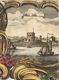
Calshot Castleas well as the harbour scene with the title cartouche.
The vignettes, the lists of Gentlemen, scale line etc are enclosed by decorative borders.


ships
sandbanks
depth soundings
leading lines
sea marks
buoys


Spithead
Stokes Bay
SOUTHAMPTON WATER OR TRISANTON BAY
Christ Church BaySandbanks are shown by dotted areas, some labelled:-

Bramble
The Shingle
A Loose shifting Sand call'd the HorseSome buoys are marked, and labelled, eg:-

Horse Buoy
Dean BuoyAnd the sea mark:-

Jack in the Basketis imprecisely located in the sandbanks at the mouth of the Lymington River or of Pylewell.
Depths, presumably in fathoms, are given by arabic numbers in sea areas. These are close and detailed within Portsmouth Harbour:-

A number of leading lines are drawn and labelled, eg:-

Gillkicker and Kicker Gill in a lineThere are pillars marked at:-

Gill Kicker
Kicker Gillwhich define the leading line.
coast form lines
headlands
cliffs

High Clift
Barton Cliff
Hengistbury Head
Hook point
Inner Spit
West Pole
docks

Other harbours and smaller docks might be labelled, eg:-

Langston Harbour
Portsmouth Harbour
Burselton Dock
castles
fortifications

Calshot Castle
Hurst Castle
[Netty] Castle
St Andrews ?Artillery style forts are:-

Cumberland Fort
South Sea CastleThere are artillery style polygonal fortifications around Portsea, Portsmouth and Gosport:-

and along the whole northern shore of Portsea Island, labelled:-
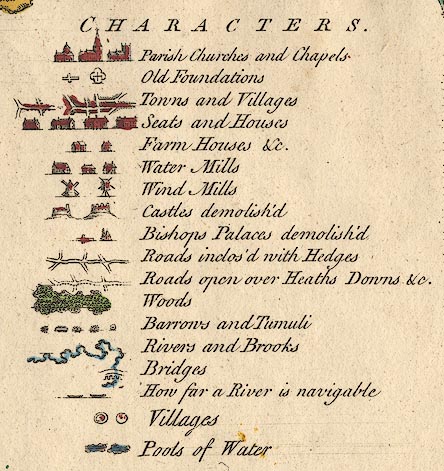
fortificationsThere is an example of a 'demolished castle', as given in the table of symbols, at North Warnborough, ie Odiham Castle:-

Also see:-

Warblington Cast.


bridges
ferries
ponds

River Itchen
Beauly River
Test
Crockford WaterAt Ash the:-
Source of ye River Hantonie the Test, is labelled:-

Picking out how far a river is navigable, as given in the table of symbols, is not easy [?not possible] even on the good map.
Bridges, mills and other features are marked and/or labelled along the rivers' courses, eg:-
Wattons Ford
Watson Bridge
Knights-bridge
Thornford Bridge
Bridge
Ogmoor Ponds
Oakhanger PondPonds, if the example of Fleet Pond is representative, are marked with shading not form lines:-

The pond in Bramshill Park has form lines:-

The symbol for a bridge in the table of symbols shows a shallow arch with numerous arches through it. In practice, on the map, a bridge is drawn by a road just crossing the river:-

The ferry across the Itchen to the east of Southampton is labelled:-
Ferrybut is mistakenly drawn as a bridge:-

water mills
windmills

Fleet MillMany more are labelled, eg:-
Sopley Mill
Bere Paper Mill
MillThe mill might be marked by a wheel with no building attached.
A mile south of Lower Wallop is:-

Overshot Millwhich is probably descriptive, rather than a name for the mill.
NE of Silchester a:-

Mill Pondis labelled.
Windmills are distinguished as post mills and tower mills by their symbols. The mill near Chalton is a post mill:-

Challton WindmillThere is a tower mill at Stoke Charity, just labelled:-

Windmilland another, clearly drawn, on Silchester Common west of Silchester. Two miles NNW of Ropley is:-
Old Windmill Stonebut no windmill. Similarly there is no mill at the group of trees called:-
Windmill Clumpnorth of Aldershot.

Lockwritten beside it.
hill hachuring

Toothillengraved along its ridge. But many aren't. 'Portsdown' is engraved off the edge of the great hill, where it may not be referring to the hill itself. There are some other names, eg:-

Butser Hill
Pix Hill
Preston Downs
Black Down
Bull HillA hill name might be implied by the name of an associated feature.
A few valleys are named, eg:-

Dean Bottomeast of Upham.

Beacon Hillmarking a small mound on top of the ridge of hills. This is the site of Farley Beacon.
Popham Beacon
Sway Beaconare labelled. There is no special symbol for beacons.
forests
trees
vegetation

Bramley FrithA wood NE of Stratfield Saye house is labelled:-

Spring WoodThe more extensive dense woodland east of Goodworth Clatford is labelled:-

Harewood ForestHackwood Park has fine avenues, running east from the house, and running north-south across the top of that. In the parkland there are larger 'specimen' trees. There are a number of avenues, in and out of parks, in the north-east of the county.
Some of the great forests are noticed, but perhaps just labelled, no trees. (Forest don't necessarily have trees.) For

Chute Forrest
NEW FORREST
Wutmere ForrestSome single trees are labelled, eg:-

The Thornwest of South Stoneham, for example, and:-

Wallers Ashtwo miles south of Stoke Charity.
Wilverly Oaksix miles NW of Lymington on the Burley road.
Fair Thornnorth of Kirbridge seems to be the label for a house and a tree drawn by the road side. A group of trees on a hillside east of Andover is:-

Tirels Treesand:-

Half Moon Treesis a half circlet of trees drawn at the end of the avenues west of Paultons House. A number of lone trees are drawn clearly, without any label, for example by the road NNE of North Stoneham.
Different sorts of country are labelled, commons not with any particular symbol. Thus marshes might be, eg:-
... Heath
... Marshes
... Commonbut might have a specific site name, eg:-

Bramshill Heath
Ipsley Moor
Hinton Common
Great Morass
Havant Chace
subscribers
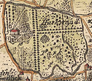
Hackwood Parkwhich has an interior line of fence as well. This park has avenues of trees, parkland with shrubs and trees, a great house with formal gardens, etc. By the house is number 18, which keys the house to 18 on the list of:-
Gentlemens Names, &c.
A
Late Rt. Hon: Ld. Arundell ... 1
Rt. Hon. Ld. Anson of Soberton ... 2
...
His Grace the Duke of Bolton Hackwood Pk. ... 18
...
Mr Yates of the Starr Southampton ... 577and an appendix of 9 more names. This list may or may not be a list of subscribers!
It is printed in alphabetical order in cartouches on sheets 1, 2, 4, and 5. There are 586 names. It is easy to find a name from the number of a house on the map. It is not easy to find a house having got the name and number from the list.
Dogmersfield Park has an entrance arch, a look-out tower or folly, a temple, and perhaps a monument. Headley Park has:-
Ariosto Templelooking like a small ziggurat. A number of park gates are labelled, eg:-
Soberton Hoe Gatein the road south of Soberton House.


Tidworth
DowntonAdjacent counties are labelled, eg:-
SURRY
BERKSHIRE
WILTSHIRE

HOLD SHOT HUNDRED
FINCH DEAN
streets
town

WINCHESTER
SOUTHAMPTON
ODIAMThe size of the place is the indicator of its importance. Winchester has crosses, for churches etc, and shaded areas - of dense building? Southampton can be imagined to have gardens behind houses, and has the 'Bridwell' labelled. Portsmouth is fortified. The size of lettering is a little smaller for lesser towns.

Minsted
Lower WallopSmaller villages are marked with dot and circle or dot and double circle; labelled in italic lowercase, eg:-

Newton Stacey
FreefolkA dot and double circle is used for:-

Eastleya bigger little place.
In practice some tiny settlements are shown as a few blocks along a road, or are settlements now but were just a house then, and shown as such.
house
farm

Gentlemen's seats are drawn as larger houses, and farms and houses are smaller. Many are labelled. Some of these places are now villages.
Old Foundationsand a cross on its side or a double narrow pyramid (!?) for:-
Bishops Palaces demolish'dThe cross on its side is used for:-

Selborne Priory
Netty Abbeyfor example. The dot in a four lobed flower at:-

Godsfieldmight be the other symbol.
milestones
road distances
distances from London
turnpike roads
signposts
Roads inclos'd with HedgesDotted lines indicate:-
Roads open over Heaths Downs &c.A great network of roads is drawn all over the county. Although the width of the roads depicted does vary, the major routes are not systematically drawn larger. The roman roads are drawn wide. Realism may be intended, see for example the varying width of one road north of West Meon.

Taylor's depiction of the roads is likely to be more realistic than Ogilby's clean and direct routes. A route, eg: following one route, Blackwater to beyond Andover, part of one of the great routes from London to the west country, it is possible to pick out the way. But the way does not stand out on the map; you do have to pick it out. Near the bridge at Blackwater is the word 'London', though it is not clear that this means the way to London. Dropping off the hills to Hertford Bridge you could be forgiven for losing your way, except that the crossing would be fairly obvious to the eye. A mile and a half further you seem to have to traverse an avenue of trees just before coming to a 'Turnpike'. There are a lot of wiggles and turns to get you to Basingstoke, and it is hoped that the map is sufficiently accurate to allow the stranger to follow these. The same is true of the way to Andover; you can miss out Whitchurch and go over the downs by taking a fork right a mile beyond the 'Turnpike' west of Worting. This route uses the Harroway over the down. This way misses the 'Turnpike Road' just east of Andover, and you would join the other route again where a finger post is marked, half a mile east of Andover near 'Tirels Trees'. Etc.
The main route is distinguished by having distances from London alongside it. Beside Blackwater is the figure '30', and along the major route there are road distances, 31, 32, etc, to Andover at 65.(These are not references to the list of names.) The intended route west is that marked with miles, past Abbots Ann on the 'Turnpike Road', out of the county to 'Labcomb Corner' in Wiltshire, but beyond Abbots Ann the road distances have been given up. This route is the equivalent of Ogilby plates 25, 26, the Lands End road from London.
One other (maybe others, can't find much) route with road distances is that crossing a corner of Hampshire by Farnborough and Aldershot Common; continuing through Farnham, Surrey; then towards Alton and Southampton? The mile numbering stops level with Bentley.
East of Andover on the turnpike is number '64':-

At Sutton Scotney is number '60' and further down the road towards Stockbridge is:-
62 Mile Stonand further on:-
Mile StoneThese are on a major route, but there don't seem to be many other indicators. At some junctions there is a finger post drawn. There's a nice example a mile west of Titchfield on Titchfield Common.

A few roads are named, some small roads, eg:-

Ratlak Lane
Hacomb Laneboth south of Hursley. A junction might be named, eg:-
Labcomb Corner [Wiltshire]which is still well known, and:-
Lambs CornerBarclay Kings. A label on the map can be descriptive, not nominative, for example:-

Drovecoming in from Wiltshire near Hale. Also:-
Green Lanefrom Worldham to Kingsley.
Popham Laneis named.
roman roads
A Roman Wayrunning SSW towards Exbury, and there are:-

Port Way Roman Way
Ikenield Way
Roman Road from Sarum to Winchester
Silchester is shown prominently with walls and roads:-

tumuli
hillforts

Barrowsthree of them, labelled west of Popham Beacons where there are more.
Kents or Canutes Barrowis marked NE of Upper Wallop.
Hillforts are drawn as a ring of embankment, and may be labelled, eg:-

Norsbury Campnorth of Stoke Charity. and:-
Bury hill Camp
Barksbury Campwest and north of Upper Clatford.


Courseis on Hazeley Heath, a hill top north of Hartley Wintney, marked with posts round a looping course.
Courseis the label for the race course on Basingstoke Down WSW of Church Oakley, marked by posts round a long oval.

Ramsey Warren
Longwood WarrenESE of Romsey and east of Chilcomb respectively.

Pest Houseie an isolation hospital on the coast of Portsea Island.
Haslar is marked, labelled:-
Hospital

Simons Stoneon the county boundary south of Frensham Pond.

Old Brickilneast of Bitterne by Westend Common, and:-
Brickilnssouth of Norman Court near West Tytherley.

Sheepwash or Monks Hill Fordwhich suggests another use for the accessible stretch of river.
Public Houseat a cross roads NW of Minstead. But also see:-
New Innsouth of Popham and the Wheatsheaf implied by the junction name 'Wheatsheaf Cross' nearby. At Barclay Kings there is the:-

Blue Boar
At the west entrance to North Stoneham Park there is:-

Banquetting Ho[ ]

Enginewhich is interesting?

Titchfield Forgesouth of Great Funtley.

Water House

Gibbet(without occupant.)

SalternTwo are shown on the east shore of Portsea Island, one labelled:-
Great SalternMore are shown on the inner shore of east side of Hayling Island.
Pyles Well Bath
School Housenear 'Rock Court' west of Boarhunt.

Cabbage Gardennorth of Lasham.
Tan houseeast of Silchester.
Chalk PitSW of Odiham.

Bevis Gravemarked by what could be taken for a long barrow. And:-
Moths Graveis labelled on the south side of Monk Sherborne.

Decoyperhaps a decoy trap for duck and other wild fowl. There is another:-
Decoy Pondthough no pond is marked, up the Beaulieu River.
Pigeon Houseon Portsdown

Salmon Wear
Four PostsAnd the:-
Wilverly Postis drawn near the 'Wilverly Oak' by the road, 5-6 miles NW of Lymington.


