 Map Group WILKES 1806


map maker

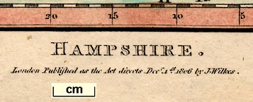
HAMPSHIRE. / London Published as the Act directs Decr. 1st. 1806 by J. Wilkes.The map includes the Christchurch area now in Dorset, and the Isle of Wight.
compass rose
up is N

Printed lower right is a compass rose; no circle, star points for cardinal and half cardinal directions, North marked by a fleur de lys. The map is printed with North at the top of the sheet.
1 to 670000
11 inches to 1 mile

There are rectangular latitude and longitude scales in the pink tinted map borders, chequered in minutes, marked every 5 minutes in arabic numerals, degrees in roman numerals. The lower border is labelled:-
Longitude Wst. from LondonReading from the map scales the:-
longitude, Winchester = 1d 12.6m Wwhich suggests a prime meridian in London well west of Greenwich, perhaps St Paul's?
sea plain
ENGLISH CHANNEL
SPITHEAD
SOUTHAMPTON WATER
coast shaded
harbours

The coast line has horizontal shading and a darker blue tint, for emphasis. The shading extends into river mouths and harbours.
Some harbours are labelled:-
Portsmouth Harbour
Langstone Harbour
fortifications
castles

There are fortifications around Portsmouth:-

bridges
ponds

Crook[ford] Waterbetween Lymington and Beaulieu rivers, off Sowley Pond? A lot of streams are drawn but accuracy is not all it could be. The Test is continued to Whitchurch but not further eastward although the Bourne Rivulet is drawn. The Itchin is continued north from Alresford then ENE towards Alton!
Bridges are implied but not stated, a river is interrupted by a road. A few are labelled:-

Our Br [Ower]
Kilcomb Bridge [nr Chilbolton]
Broken bridge [nr Denny Lodge]or implied:-
Gr[ ] Bri Mill [N of Romsey]At least one pond is labelled, though not drawn:-
Bistern Pondand Fleet Pond is drawn but not labelled.
Quarley Hill camp
Gilbert Hill [NW of B's Waltham]
Filmer Hill
forests
vegetation

The Holt Forest [ie Alice Holt]
Woolmer Forest
Forest of East Bere
NEW FORESTand there are a few woods:-
Mays Cops [E of East Bere F]
Litchfield Woodperhaps just implied:-
Dole Wood Lodge [H'bourne Tarrant]Some common lands are labelled, eg:-
Week Comm.
Curdridge Common
Yately Heath

Freemantle Park
Dogmersfield
Harewood Park
Idesworth

The county boundary is a dotted line. The whole county is tinted plae yellow, and the boundary has a stronger yellow tint for emphasis. Some adjoining counties are labelled, eg:-
WILT SHIRE
SUSSEXThe adjacent counties have a border tint: Dorset pink, Wiltshire green, Berkshire pink, Surrey blue, Sussex pink. This is more colours than are necessary.
distances from London
town

WINCHESTER / 54

STOCKBRIDGE / 68
FORD OF ALRESFORD / 67The expected towns are marked in this way, but also Broughton! The figures by a town are the distance from London.
hamlet

Upper Wallop
TwyfordSome villages have a small group of blocks on a road instead of the cross, eg:-
PorchesterThere are confusions, eg:-
Farehamwith a + marked and labelled just north of:-
FAREHAMshown as a town.
Not all villages have the cross, eg:-
Empshot
E. Deanand villages might be very small, eg:-
Little Worldham
Farley

Lower Froyle
Burcotbut this labelling id used for other features as well.
Millbarrows Lower Fa.near Corhampton fortifications At Portsmouth the fortifications are shown in crude outline.

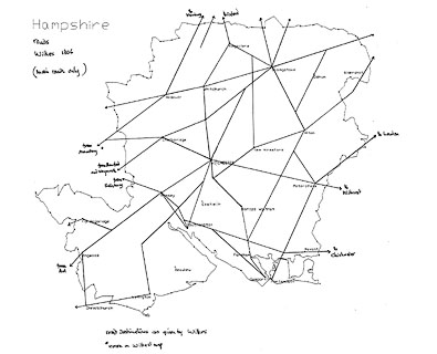
Roads are drawn with a double line; they are graded into major and minor roads by width. The major roads (nearly) all have one line bolder than the other, and are tinted pale brown or orange.
There are a few road names, eg:-

Bagg Lanebetween Lymington and Christchurch. The destinations of roads outside the county is sometimes given, eg:-
to Oxford
from Amesbury
from Blandford and Weymouth
to London

water mills

G[ ] Bri Millon the Test, north of Romsey
hillforts

Quarley Hill Camp
Dunbury Camp
roman roads

Roman Road from Sarumto Winchester.
The Portway is clearly drawn, but not labelled.

New Innby the cross roads south of Privett.

Worthy Dean Coursecopying a spelling mistake from an earlier map. The race course looks like a park.
Steventon Cross
| Basingstoke - Winchester | 67mm | 28 miles | 1 to 672562 | |
| Basingstoke - Southampton | 112mm | 46 miles | 1 to 660981 | |
| Basingstoke - Portsmouth | 126mm | 53 miles | 1 to 676946 | |
| Basingstoke - Christchurch | 184mm | 77 miles | 1 to 673475 |
1 to 670000
11 miles to 1 inch


