|
Research Notes
 Map Group BURT 1887
|
 |
|
Burt 1887
|


|
 |
THE DURLSTON GLOBE: BURT'S GLOBE, DURLSTON HEAD, 1887 |
 |
THE DURSLTON MAP: BURT'S MAP, DURLSTON CASTLE, 1887 |
 |
HAMPSHIRE TOWNS |
 |
|
| THE DURLSTON |
GLOBE: BURT'S GLOBE, DURLSTON HEAD, 1887 |
|
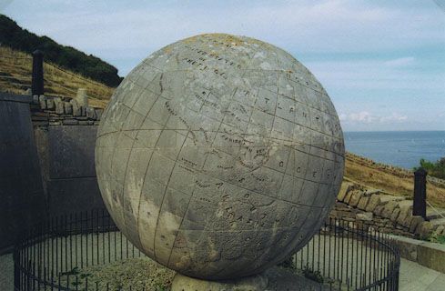
Located at Durlston Head near Swanage, map reference SZ0377,
is a 40 ton globe of portland limestone, given to the town of
Swanage my George Burt, 1887. The map of the world is done in
simple relief; land areas are raised and the surface pecked, sea
areas are smooth. After a century and a bit the globe is still
readable though the land outlines and lettering are softened by
weathering.
|
lat and long grid
|
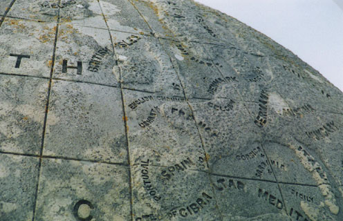
The globe has a graticule of lines of latitude and longitude
at 10 degree intervals incised over the whole surface. On the
equator is a label:-
LONGITUDE WEST OF
GREENWICH
and presumably a corresponding 'east' label. Figures 10, 20,
etc are carved against the meridians, for longitude. Carved at
each parallel along the prime meridian are labels 10, 20, etc,
for latitude.
|
sea plain
|
Some sea areas are labelled, eg:-
NORTH ATLANTIC OCEAN
ENGLISH CHANNEL
|
countries
|
Country names are mostly carved in the country area, eg:-
FRANCE
though the label for:-
BRITISH ISLES
is carved in the surrounding seas.
|

| top of page |
 |
|
| THE DURSLTON |
MAP: BURT'S MAP, DURLSTON CASTLE, 1887 |
|


|
|
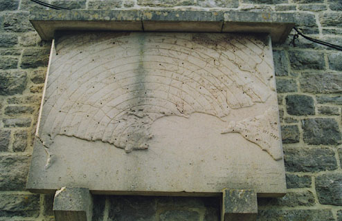
On an outside wall of Durlston Castle, now a tearooms, is a
limestone map of the area around Durlston, including parts of
Dorset and Hampshire. The map shows about 30 miles round about
Swanage on a rectangular slab of stone. The slab is protected by
a cill of stones above. This has reduced weathering, though the
map is stained by drips coming through unnecessary joints in the
overcill.
|
table of symbols
scale
|
An inscription lower right:-
THE BROKEN LINES SHOW BOUNDARIES OF
COUNTIES
THE CIRCLE LINES [an arc] SHOW
DISTANCES FROM SWANAGE AT EVERY 2 MILES
- SCALE 1 INCH TO 1 MILE -
The nominal scale of the map is
1 to 63360
1 inch to 1 mile
|
orientation 7 up is n
|
The map is carved with North at the top of the slab.
|
sea plain
coast line
|
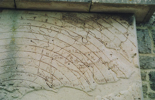
The sea are is plain, some areas labelled, eg:-
ENGLISH CHANNEL
SOLENT
SOUTHAMPTON WATER
The land area is in relief, but not showing any relief
features. The coast line is just the boundary between the two.
Some headlands are noticed, eg:-
HENGISTBURY H[D]
|
coastal defence
castles
|
On Hurst Spit there is:-
HURST CASTLE
|
rivers
|
Rivers are incised lines, tapering inland. Two are
labelled:-
R. STOUR
R. AVON
In Hampshire it is possible to recognise the River Stour and
Moors River, River Avon, Lymington River, Beaulieu River, Bartley
Water, River Test, and River Itchen. There are a few smaller
streams as well.
|
forests
|
NEW FOREST
is labelled.
|
county
|
The county boundary is a dotted line. County areas are
labelled:-
DORSET
HANTS
Hampshire includes the area up to Bournemouth which is now
part of Dorset.
|
settlements
|
Settlements are located by an incised spot, and labelled,
eg:-
CHRISTCHURCH
LYMINGTON
|
monuments
|
On the north edge of the New Forest is:-
RUFUS STONE
|

| top of page |
 |
|
| HAMPSHIRE TOWNS: |
Of the '21' market towns, remember this map is not all of the
county, there are:-
|
|
|
|
Christchurch
|
|
Fordingbridge
|
|
Lymington
|
|
Ringwood
|
|
Romsey
|
|
Southampton
|

| top of page |
|
 |
All Old Hampshire Mapped Resources |

 Map Group BURT 1887


