|
Research Notes
 Map Group DITCHLEY 1592
|
 |
|
Ditchley 1592
|
|
|
|
These notes about Hampshire are taken from the Map in the
'Ditchley' Portrait of Queen Elizabeth I, by Marcus Gheeraerts the
Younger, about 1592. The portrait is in the Collection of the
National Portrait Gallery, London.
|
|
NB: these notes ignore the portrait and look at the map.
Although the painting is in a public collection it is hedged
round with access restrictions; no images from the map can be
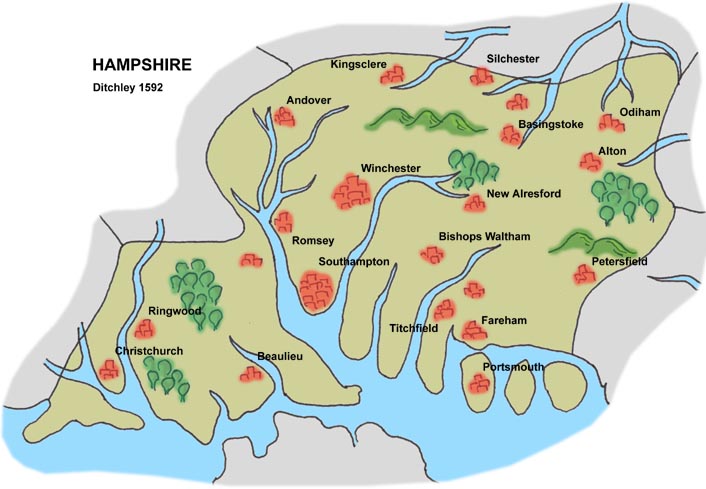
included with these notes. A sketch of Hampshire from the
painting has been made.
|
 |
MAP FEATURES |
 |
THE DITCHLEY PORTRAIT |
 |
|
|

|

| top of page |
 |
|
| MAP FEATURES |
|
|
The notes below are made from a critical stance judging the
map as a map. Do keep in mind the map was painted only as a
symbol, as an added element to a royal portrait.
|
sea area
sea painted
ships
|
The sea is painted a dark blue-green, decorated with ships.
For example, off Kent there is a three masted 'galleon';
spritsail, fore mast with main and top sails, main mast with main
and top sails, mizzen mast with a lateen sail, and various
flags.
|
coast line
harbours
|
The coast line is indented by oversize estuaries of rivers.
The three islands of Portsea, Hayling, and Thorney can be
recognised. Christchurch Harbour is obvious, as are Southampton
Water and Portsmouth and Langstone Harbours. the shape of the
Solent and Spithead leaves a lot to be desired between the county
and an ill shaped Isle of Wight.
|
rivers
|
Rivers are painted dark blue-green like the sea. They are
crudely wide judged as cartography, though from a design stance
they are fine.
In Hampshire it is possible to recognise the Stour and Moors
River, Avon, Lymington River, Beaulieu River, Test with a muddle
of tributaries perhaps including the Wallop and Anton, Itchen,
Hamble, Meon, the start of the Wallington River, the Rother which
does not reach into the county, Wey, Blackwater, perhaps the
Hart, Loddon and Lyde, and the Enborne.
|
relief
hillocks
|
Painted hills, green humps, suggest some relief. There is a
group in the middle of the county, north of Winchester, south of
the River Loddon system, which are Hampshire Downs. And a group
north of what is probably Petersfield, part of the South
Downs.
|
forests
|
Groups of trees are painted to indicate forests. Two groups
decorate the New Forest area. A group on the east is probably
Woolmer Forest, which was an important royal holding. There is
another group of trees north of ?Alresford.
|
county
|
Each county on the map is painted a different colour, the
colour a little deeper at the boundary, but there is no boundary
line. Hampshire is a yellowish green, Wight is pale purple,
Dorset pale purple, Wiltshire mid green, Berkshire a greeny
yellow, Surrey pink, Sussex greeny yellow. From a cartographic
point of view the choice of colours is poor, failing to clearly
delimit counties, and having one colour, Kent's very dark green,
badly out of balance with the rest.
The county areas are labelled, round Hampshire there are:-
DORCESTRIA
WILTONIA
HANTONIA
BERCERIA
SURRIA
SOUTHSEXIA
WIGHT
etc.
|
settlements
|
Settlements are shown as stylised prospects of groups of
buildings, bigger groups for bigger places. Few places are
labelled, in Hampshire;-
Winchester
Shampton
It is possible to recognise most of the places shown in the
county: Alton, Andover, Basingstoke, ?Beaulieu, Bishops Waltham,
Christchurch, Fareham, Kingsclere, New Alresford, Odiham,
Petersfield, Portsmouth, Ringwood, Romsey, ?Silchester,
Southampton, ?Titchfield, Winchester, and three others.
Christopher Saxton's atlas of county maps is probably the best
source to use for the identifications of places.
|

| top of page |
 |
|
| THE DITCHLEY |
PORTRAIT |
|
|
|
The portrait of Elizabeth I was painted in oil on canvas by
Marcus Gheeraerts the Younger about 1592, for Sir Henry Lee,
1533-1611, who was the Queen's Champion 1559-90. It was most
likely painted to commemorate an elaborate entertainment which
Sir Henry organised for the queen, September 1592, held either at
his house at Ditchley, Oxfordshire, or at nearby Woodstock
Palace.
|
|
The overall size of the portrait is: wxh = 1.5x2.4m.
|
|
Queen Elizabeth is shown standing on a globe, her feet rest on
an outsize - compared with the curve of the globe which can be
seen behind her - map of Great Britain. Beneath her feet it is
possible to see the south of England from the edge of Cornwall to
Kent, and St David's Head in south Wales. Her dress hangs to the
north of Bristol - Oxford - Middlesex - part of Essex. The size
of Hampshire in the painting is about 28x16.5cm. The county is
misshapen, squashed N-S, foreshortened by the perspective view
from the south.
|

| top of page |
|
 |
All Old Hampshire Mapped Resources |

 Map Group DITCHLEY 1592


