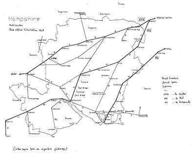
 Map Group POST OFFICE 1823

Beaton, David: 2001: Dorset Maps: Dovecote Press (Stanbridge, Wimborne, Dorset BH21 4JD):: ISBN 1 874336 79 2


up is N
WINCHESTERThe capital 'LONDON' is in upright block caps.
Andover
Botley
Kingsclere
10between Alton and Alresford.
Outside restricted Penny Post regions, like metropolitan London, the charges for delivery depended on distance. A single letter up to 15 miles was 4d (old pence, about 2 new pence), then there was a sliding scale for longer distances.


post roads
The principal routes that concern Hampshire are XVIII, XIX and XX. Other main routes, cross routes, involving Hampshire are passing through Salisbury to beyond Chichester, and running south through the tip of Hampshire near Shipton Bellinger.
A number of minor routes are also drawn.

XVIII - from London; through Staines, Middlesex; Bagshot, Surrey; then Blackwater, Hartford Bridge, Basingstoke, Overton, Whitchurch, Andover, Wallop, Hampshire; to Salisbury, Wiltshire; on to Exeter and Plymouth, Devon.
XIX - from London; through Bagshot, Surrey; across a corner of Hampshire; through Farnham, Surrey; then Alton, Alresford, Winchester, Southampton, Redbridge, Stony Cross, Ringwood, Hampshire; to Wimborne and Poole, Dorset.
XX - from London; through Guildford and Godalming, Surrey; then Liphook, Petersfield, Horndean, Cosham, to Portsmouth, Hampshire.
cross route - through Salisbury, Wiltshire; then Romsey, Southampton, Fareham, Cosham, Havant, Emsworth, Hampshire; and beyond Chichester, West Sussex.
cross route - from Ramsbury, across the Great London Bath road, Wiltshire south through a corner of Hampshire; missing Salisbury, Wiltshire; to the coast of Dorset near Lulworth?

