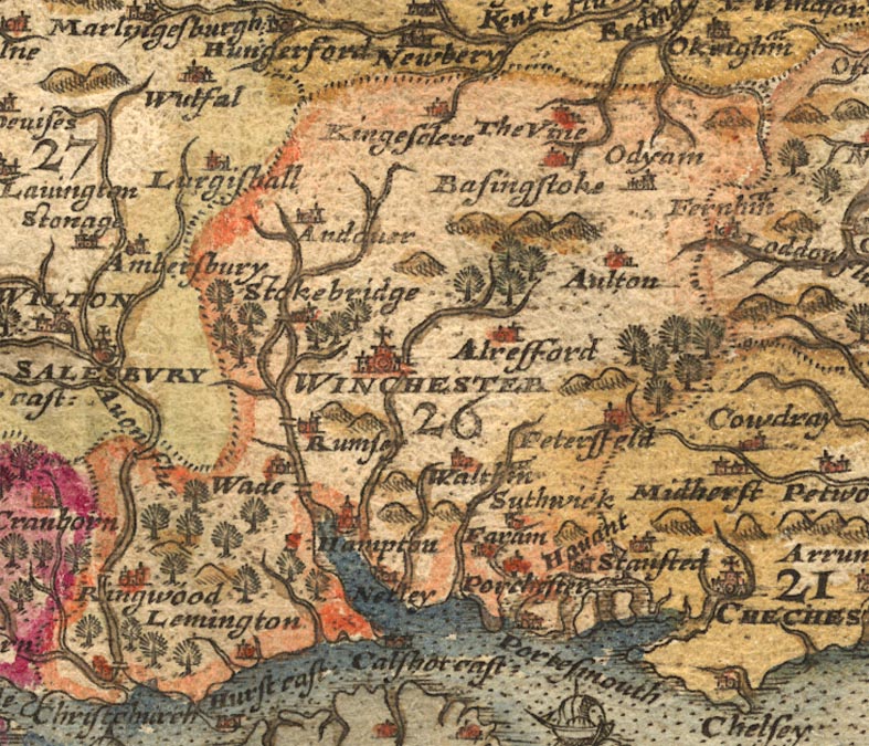
 Map Group SAXTON 1579

The copy studied is in the first state, and is in a private collection to whose owner I am grateful.
I have also studied the reproduction of the map in the library at Chatsworth House, Derbyshire, published in:-
Ravenhill, William: 1992: Christopher Saxton's 16th Century Maps: Chatsworth Library:: ISBN 1 85310 354 3


strapwork cartouche
coat of arms

Printed upper right is a strapwork cartouche decorated with a few fishes and lobsters, etc:-
ANGLIA
hominu~ numero reruniq~ fere omniu~ copijs abundans; sub mitissimo Elizabethae, serenissima et doccissima Reginae, imperio, placidissima pace annos iam viginti florentissima.
Ano. Dmi~ 1579

Above the cartouche is a royal coat of arms; the three lions of England quartered with the three fleur de lys of France; supported by a lion and dragon, and the cypher E R for Elizabeth Regina.

Printed lower right is the coat of arms of Thomas Seckford, Master of Requests to Elizabeth I, who was Saxton's patron in the official project to map the country. It has the motto:-
INDUSTRIA NATURA ORNAT.
compass rose
labelled borders
up is N

SEPTENTRIO
ORIENS
MERIDIES
OCCIDENSAt the middle of each side, against the border, is a half compass rose; marked for the cardinal, half cardinal, false and by points; North marked with a fleur de lys, East with a cross.
The longitude of:-
Greenwich is 23d 30m East
Winchester is 22d 1m EastThe prime meridian is 23d 30m West of Greenwich, somewhere about the Cape Verde Islands.
map maker
engraver
dividers

Scala MiliariumThe 50 miles is divided at 1/2 miles, labelled at 5 mile intervals. Above the scale is a splendid pair of dividers with a scroll draped on them:-

Christophorus Saxton descripsit.In a cartouche below the scale is:-
Augustinus Ryther Anglus Sculpsit. Ano. Dni~. 1579.Augustine Ryther was a Fleming emigrant to England, proud to call himself 'Anglus'. He engraved 5 of the county maps in Saxton's set of counties.
sea pecked
ships
sea monsters

The sea area is stippled and tinted blue;
The sea is busy with ships, from a rowing boat off Cornwall about Padstow, to 3 masted carracks. Enormous fishes swim in the sea.

Neptune with crown and trident, and a nymph of course, grace the Irish Sea.
The main sea areas are labelled, eg:-
OCEANUS BRITANNICUS.Sea areas relevant to Hampshire which can be recognised easily are:-
Solent
Southampton water
coast shaded
harbours

the coast shaded for emphasis with a darker blue tint.
Harbours relevant to Hampshire which can be recognised easily are:-
Portsmouth Harbour
Langstone Harbour
castles

Hurst cast
Calshot castNetley is shown as a place altho it is not a town; maybe because there was a castle here.
bridges

Stour = Stowr flu:
Avon = Avon flu:
Bourne (tributary of Avon)
Lymington River
Beaulieu River
Test
Anton (tributary of Test)
Itchen
Hamble
Meon
Wallington River
Rother
Criddell Stream (tributary of Rother)
Wey = Loddon flu (wrongly labelled)
Blackwater River
Loddon
Hart (?)
EnborneAll of which have tributary streams whose identification is less certain.
Bridges are drawn by a double line crossing a river. The bridges shown in Hampshire are at:-
Christchurch
Ringwood
Redbridge
Romsey
Stockbridge
Winchester
hillocks

Relief is indicated by hillocks, tinted with a patch of pale brown. These have not been looked at in detail.

Woodland areas are indicated by tree symbols, tinted green. The symbol has trunk, a few shading lines at the bottom for ground, and branches radiating round the top; this is unlike some later tree symbols. Their distribution has not been looked at in detail.
The Vineis labelled. This house was the seat of one of the politically influential lords of Elizabeth's court.
table of counties

County boundaries are drawn by dotted lines. The county areas are labelled with a number referring to a table of counties which is printed upper left in a strapwork cartouche:-

INDEX OMNIUM COMITATUM, notis et figuris suum ciusq~ situm et ambitum designatibus
1. Nothumbria
2 Dunelme~sis
...
26 Southamptonia
27 Wiltonia
28 Dorcestria
29 Somersetus
30 Devonia
31 Cornubia
...
52 CardiganHampshire is bracketted together with the more south western counties.
On the map studied some of the county areas are coloured, some just have a tint along their border. Hampshire has an orangey boundary, Dorset magenta, Wiltshire pale green, Berkshire yellow fill and darker yellow boundary, Surrey pale brown, Sussex pale green; all the colours are faded or aged.
IN a cartouche below this is:-
Animadvertum; nos propter locoru~ [a]ngustias urbes tantu~ oppida mercatoria castella et loca quaedam celebratiora hac tabula inclusisse.

WINCHESTER

Aultonwhich text style also labels any other feature.


Alresford
Andover
Basingstoke
Christchurch
Farh~m [easily read as Faram]
Havant
Kingesclere
Lemington [easily read as Lamington]
Netley [easily read as Nerley]
Odyham [easily misread as Odyhani]
Petersfeld
Porchester
Portesmouth
Ringwood
Rumsey
S: Hampton
Stokebridge
Suthwick
The Vine
Wade
Waltham [easily read as Walram]
WINCHESTER


