|
Research Notes
 Map Group UNKNOWN 1800s
|
 |
|
Unknown 1800s
|
|
|
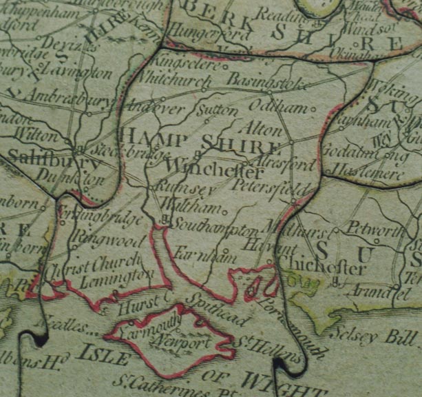
These notes about the county of Hampshire are taken from a
Jigsaw Map of England and Wales, published about 1800. The jigsaw
is in the Blaise House Museum collection, Bristol, item
BRSMG:T9119.
|
| |
 |
MAP FEATURES |
 |
HAMPSHIRE TOWNS |
 |
|
| MAP FEATURES |
|
|

|
|
The jigsaw map is of England and Wales, divided into counties.
Before being dissected it had a border with scales of latitude
and longitude. Only one county has been studied; Hampshire.
|
| |
orientation
up is N
|
The map is printed with North at the top of the sheet.
|
lat and long scales
|
The original map had scales of latitude and longitude in its
borders. One small segment remains on the jigsaw puzzle.
|
sea area
sea plain
|
The sea area is plain, some areas labelled, eg:-
ENGLISH CN[ ]
the remainder cut off by the dissection, and:-
Spithead
Southampton Water is clearly recognisable.
|
coast line
coast shaded
harbours
islands
|
The coast line is shaded.
The large harbours and islands, Portsea Island and Hayling
Island, are recognisable, but ill drawn.
|
rivers
|
Major rivers are drawn by wiggly lines tapering upstream. In
Hampshire it is possible to recognise the Stour, Avon, Test,
Itchen, Meon, Rother, Blackwater, Hart and Loddon, and Enborne,
plus some tributaries like the Wallop and Anton.
|
county
|
County boundaries are dotted lines, tinted for each county;
Hampshire is red. The county areas are labelled, eg:-
HAMP SHIRE
|
settlements
|
Settlements are marked by a circle, with a tower for large
places, differentiated by style of lettering.
|
|
city
|
circle and tower; labelled in upright lowercase text, eg:-
Winchester
|
|
|
town
village
|
circle; labelled in italic lowercase text, eg:-
Alton
Sutton [Scotney]
A large town might have a tower with the circle.
|
|
|
roads
|
Roads are drawn by a double line. The routes shown in
Hampshire are:-
from London; via Staines, Middlesex;
across Surrey; through Basingstoke, Whitchurch, Andover,
Hampshire; then Salisbury, Wiltshire; and west.
branch from Andover, Hampshire; then
Ambresbury, Wiltshire; and west.
branch from Basingstoke, through Sutton
[Scotney], Stockbridge, Hampshire; then Dunkton, Wiltshire; and
west.
from London; via Staines, Middlesex;
through Farnham, Surrey; then Alton, Alresford to Southampton,
Hampshire; AND from Southampton, through Romsey, Hampshire; then
Salisbury, Wiltshire; etc.
branch from Alresford, through
Winchester, then Romsey, Hampshire; to Salisbury, Wiltshire; etc.
from London; via Godalming, Surrey;
then Petersfield towards Portsmouth, Hampshire.
perhaps from Oxford, Oxfordshire;
across Berkshire; through Basingstoke, Alton, Petersfield,
Hampshire; to Chichester, West Sussex.
|

| top of page |
 |
|
| HAMPSHIRE |
TOWNS |
|
20 of the '21' market towns of Hampshire are all shown, named
as follows:-
|
|
Alton
|
|
Andover
|
|
Basingstoke
|
|
Waltham
|
|
Christ Church
|
|
Farnham
|
|
Fordingbridge
|
|
-
|
|
Havant
|
|
Kingsclere
|
|
Lemington
|
|
Alresford
|
|
Odiham
|
|
Petersfield
|
|
Portsmouth
|
|
Ringwood
|
|
Rumsey
|
|
Southampton
|
|
Stockbridge
|
|
Whitchurch
|

| top of page |
|
 |
All Old Hampshire Mapped Resources |

 Map Group UNKNOWN 1800s


