|
private collection:-
|
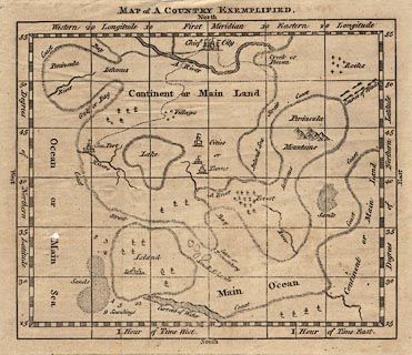
Map, uncoloured engraving, Map of a Country Exemplified, a fictional map for
teaching, showing map features, 18th century.
|
|
map feature:-
|
not coloured & labelled borders & up is N & lat and long scales
& lat and long grid & time from Greenwich & sea plain & depth
soundings & sandbanks & coast shaded (no line) & rivers & relief
& hill hachuring & hillocks (for mountains) & woods & forests
& trees & settlements & roads (?few) |
|
inscription:- |
printed -on- title, at top
MAP of A COUNTRY EXEMPLIFIED.
|
|
dimension:- |
wxh, sheet = 19x17.5cm |
|
wxh, map = 162x137mm |
 |
|

|
Map Group -- Unknown 1700s
|
 |
|

| top of page |
| MN: 16.12.2002 |


