|
private collection:-
|
Guide book, England, an Intended Guyde for English Travailers, by John
Norden, London, 1625.
|
|
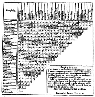
The book has a sheet for each county for a triangular table of distances with a
thumbnail map of the county in the spare triangular space. The map is very
small. There are also instructions for using the table; 'Invented by JOHN
NORDEN.'
|
|
inscription:- |
printed -on- title page
England / AN / Intended Guyde, / For / English Travailers. / Shewing in
generall, how far one / Citie, & many Shire- Townes in England, are / distant
from other Together, with the / Shires in perticular: and the Cheife / Townes in
every of them. / With a generall Table, of the most of / the principall Townes
in Wales. / Invented & Collected, / by John Norden. / Voluntas pro facultate. //
Printed at London by Edward / All-de dwelling neare Christ- / Church 1625.
-- scroll cartouche with figures, one reading and one playing a lute, cherubs,
etc |
|
inscription:- |
printed -on- title cartouche, Hampshire table of distances
Hamshire
|
|
dimension:- |
wxh, book = 18.5x25cm |
 |
|

|
Map Group -- Norden 1625 -- with Research Notes
|
 |
|

| top of page |
| MN: 16.12.2002 |


