Map Collection

Musgrave 1717
private collection:- 
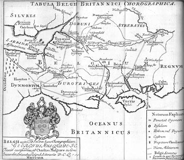
Map, uncoloured engraving, Belgium, the land of the Belgae, southern England, scale about 22.5 miles to 1 inch, by George Musgrave, 1717, drawn for his brother's book, Antiquitates Britanno-Romanae, by William Musgrave, published London, 1719.
map feature:-  not coloured & title cartouche & coat of arms & table of symbols & labelled borders & up is N & sea plain & coast shaded & harbours & rivers & tribal areas & settlements & antiquities & roman roads
dimension:-  wxh, map = 21x18.5cm
scale = 1 to 1400000 ? (estimated with DISTTAB.exe)

  Map Group -- Musgrave 1717 -- with Research Notes

  top of page
MN: 16.12.2002