|
private collection:-
|
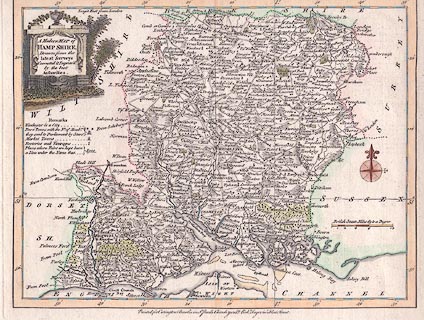
Map, hand coloured engraving, Modern Map of Hamp Shire ie Hampshire, scale
about 7 miles to 1 inch, published by Carington Bowles, St Paul's Churchyard,
and Robert Sayer, Fleet Street, London, after 1763.
|
|
The map is a close copy, a new engraving, from the map by Thomas Kitchin,
published 1763.
|
|
map feature:-
|
title cartouche & monumental cartouche & compass rose & scale line
& lat and long scales & lat and long grid & table of symbols &
sea plain & coast shaded & castles & rivers & relief & hill
hachuring & woods & forests & parks & county & settlements
& roads |
|
inscription:- |
printed -on- title cartouche, upper left
A Modern MAP of / HAMP SHIRE, / Drawn from the / latest Surveys / Corrected
& Improv'd / by the best / Authorities.
|
|
inscription:- |
printed -on- bottom
Printed for Carington Bowles in St. Pauls Churchyard, & Robt. Sayer in Fleet
Street.
|
|
scale line:-
|
10 miles = 37.5 mm |
|
dimension:- |
wxh, map = 247x189mm (roughly) |
|
scale = 1 to 430000 ? (1 to 429158 from scale line assuming modern mile) |
 |
|

|
Map Group -- Bowles 1763 -- with Research Notes
|
 |
|

| top of page |
| MN: 2.7.2004 |


