|
private collection:-
|
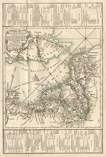
Road map, hand coloured engraving, Paris to Normandy, Flanders and London, by
Mr Michel, published by Sr Desnos, Rue St Jacques, Paris, France, 1765.
|
|
Plate 10 has routes from Paris to Normandy and Flanders, and three routes to
London - from Calais to Dover then through Canterbury, and Dartford to London;
Dieppe to Newhaven, thence London; and Cherbourg to Portsmouth, then through
Cosham, and Petersfield, Hampshire, then Guildford and Kingston on Thames,
Surrey, to London.
|
|
map feature:-
|
title cartouche & rhumb lines & lat and long scales & sea plain
& coast form lines & rivers & relief & hill hachuring (?) &
woods & forests & settlements & roads & itineraries &
shipping routes |
|
inscription:- |
printed -on- barocque cartouche, upper left
Xe. Flle. / L'INDICATEUR FIDE[grave]LE / du Voyageur Franc[cedila]ois. /
ROUTES des Provinces de Normandie, / Boulon~ois. Partie de la Flandres et Pi- /
cardie, et Route de Paris a[grave] Londres, / sc[cedila]avoir par Dieppe et
Calis &c. / Par Mr. Michel, / Inge[acute]nieur - Ge[acute]ographe du Roy, /
a[grave] l'Observatoire Royal. / a[grave] Paris, chez le Sr. Desnos, Ingr.
Ge[acute]og. / pour les Globes et Sphe[grave]res, rue St. / Jacques, au
Globe.
|
|
dimension:- |
wxh, sheet = 34x50.5cm |
|
wxh, plate = 315x472mm |
|
wxh, map = 309x320mm |
 |
|

|
Map Group -- Michel and Desnos 1765 -- with Research Notes
|
 |
|

| top of page |
| MN: 23.8.2003 |


