|
private collection:-
|
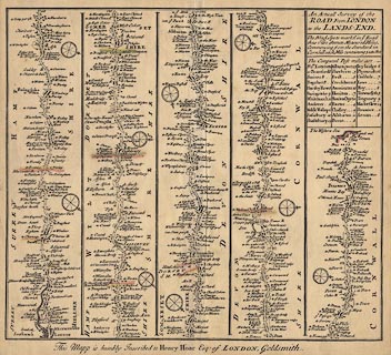
Strip map, road map, uncoloured engraving, Road from London to the Lands End,
scale about 6 miles to 1 inch, from The Roads of ye South Part of Great Britain,
by Herman Moll, London, 1718.
|
|
from London; via Staines, Middlesex; Bagshot, Surrey; Blackwater, Hartford
Bridge, Basingstoke, Basingstoke, Whitchurch, Andover, and Middle Wallop,
Hampshire; then Salisbury, Wiltshire; and westward across Dorset; and Devon; to
Lands End, Cornwall.
|
|
map feature:-
|
not coloured & title cartouche & plain cartouche & compass rose
& up is destination & coast shaded & rivers & county &
settlements & roads & distances from London |
|
inscription:- |
printed -on- title cartouche, upper right
An Actuall Survey of the / ROAD from LONDON / to the LANDS-END.
|
|
inscription:- |
printed -on- bottom
This Mapp is hubly Inscribed to Henry Hoar Esq: of LONDON, Goldsmith.
|
|
dimension:- |
wxh, sheet = 31.5x29.5cm |
|
wxh, map = 299x263mm |
|
scale = 1 to 390000 ? (rough estimate from a few road distances) |
 |
|

|
Map Group -- Moll 1718 -- with Research Notes
|
 |
|

| top of page |
| MN: 27.8.2003 |


