
 Return to list of Features

NB: typical illustrated examples are described, NOT ALL examples.
absence of evidence is not evidence of absence
'old trenches and fortes' are marked on the map. For example the hillforts at Burghclere, by the beacon, and at Butser.
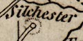
Silchester and Danebury have the symbols for 'places ruinate and decaid'.
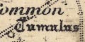
The table of symbols has a symbol for earthworks:-
Old trenches and fortes
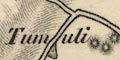
This is a hatched circle much like the tumulus symbol commonly used today, plus a flag. Some of the sites are named, eg:-
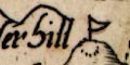
Butserhill
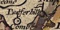
Dunbury hillOther sites can be identified, eg:- Bury Hill site, Hengistbury Head site, Beacon Hill site at Burghclere, etc.
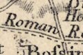
Some roman sites are named, for example:-
Venta
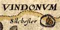
Vindonum
Clausentum
Some british tribal areas are labelled, eg:-
THE SEGONTIANSin the north, and:-
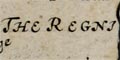
THE REGNIin the south west of the county. Southampton water is labelled:-
CLAUSENTUMwhich is done from an interpretation of the name?
Dunbury hill is marked, other hills are not, so the name might imply something is special, ie the hillfort.
The added historical place names are mostly in bold italic text:-
Caer Segonte / Vindonum [Silchester]
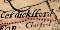
Cerdicksford [Charford]
Clausentum [Southampton]
Regnum [Ringwood]
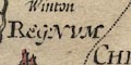
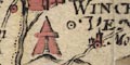
Venta Belgarum [Winchester]
THE SEGONTIANS [area about Pamber]
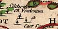
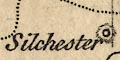
Silchester is drawn as a village and/or park, and is labelled with its old name:-
Silchester ol VindonumAntiquities are not really noticed by the map. Winchester is also given an old name:-
Venta Belgarumas are Ringwood - Regnum, Christchurch - Twinamburn, Broughton - probably wrongly as Brage or Brige.
A number of place names for ancient towns and british tribal areas have been added:-
Christchurch river mouth (?) :-
ancient name:-
ALAUNI. FLU OSTIUM
New Forest :-
ancient name:-
YTEMEThis should be Ytene?
Ringwood :-
ancient name:-
REGNUMdistanced from the town?
Silchester :-
ancient names:-
CAER SEGONTE
VINDONUMwhich are not now accepted?
Southampton :-
ancient name:-
CLAUSENTUM
Winchester :-
ancient name:-
VENTAThis is usually Venta Belgarum
Three british tribal area names are added, though it not very clear what the areas are:-
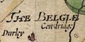
THE BELGIAElabel S of Winchester, usually Belgae;
THE REGNIlabel N of Southampton;
THE SEGONTIANSlabel S of Silchester.
The lettering of all these additions is in decorative italic block caps.
There are also two 'tent' symbols added; on the north edge of Southampton, and to the south of Winchester.
A netword of roman military roads is drawn by double lines. The routes shown in Hampshire are:-
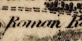
from Calleva - Henley, Berkshire; through Vindomis - Silchester, Venta Belgarum - Winchester, Clausentum - Southampton, to Regnum Vetum - Ringwood, Hampshire.
branch from Venta Belgarum - Winchester, Hampshire; to Sorbiodunum - Salisbury, Wiltshire, whence south and west.
The whole map is a map of antiquities, it includes one ancient place especially worth noting:-
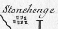
Stonehenge
The coast line is shaded for emphasis. The coast line is also tinted; pale green-blue around England and Wales, pale green around France, pink for Scotland and Ireland, and the Isle of Man.
Some headlands are noticed, eg:-
Dumnoniorum Prom. / Start Pt.where there is a roman place name.
Hampshire's harbours are not noticed. Elsewhere some are labelled, eg:-
Dubris Portus / Dover
Portus Madurni / AldringtonThe latter is an example of misinterpretation by Stukeley. It is likely to be Portus Ardaoni thought to be the roman fort at Portchester, Hampshire.
Rivers are shown by a wiggly line. Hampshire has the Stour and Avon, Test, Itchin, and perhaps the Rother. Rivers are not labelled, but see:-
Tamesis Fl.
Sabrina AEstariumat these great river mouths.
Ancient british tribal areas are not generally noticed. Three areas are labelled, at the edges of roman influence:-
CORINAVII
DUMNONIIin the far south west, and:-
OTODINIin the scottish borderlands.
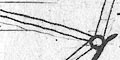
Settlements are positioned by a circle and most have a pair of towers to indicate a town. Less significant places have no, or smaller, towers. Only settlements along the itineraries are marked; labelled in Latin and English as noted above.
The places in Hampshire are:-
Regnum / Ringwood
Bragae / Broughton
Venta Belgarum / Winchester
Trausantum / Southampton
Vindoma / Silchesterand close around:-
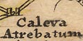
Caleva Atrebatum / Farnham
Sorbiodunum / Old Sarum
Vindogladia / Winborn
Spina / Speen
Cunetio / MarleboroughThe place name interpretations MUST be read in conjunction with a more recent authority, eg Rivet and Smith.
The itineraries are drawn as roads by double lines, tinted yellow. Each road is labelled, if you look carefully, with its number, eg:-
ITER XV.and might be named, eg:-
VIA ICENIANA / Ikening Street
Four of the itineraries cross Hampshire. Their interpretations by Stukeley and by Rivet and Smith are compared in the lists below (my punctuation). Rivet and Smith do have the advantage of 250 years of scholarship and excavation evidence. And still ideas are not settled; the whereabouts of Brige is not agreed, for one instance.
Itinerary 7 :-
Stukeley:-
ITER VII. - Londinium; Pontes / Stanes; Caleva Atrebatum / Farnham; Venta Belgarum / Winchester; Trausantum / Southampton; Regnum / Ringwood.Rivet and Smith:-
Iter VII - Londinio; Pontibus / Staines; Galleva Atrebatum / Silchester; Venta Belgarum / Winchester; Clausentum / Wickham or Bitterne, Southampton; Regno / Chichester.
Itinerary 13 :-
Stukeley:-
ITER XIII. - Isca Leg. II. Aug. / Caerleon; Burnium / Usk; Bescium / Old Town; Ariconium / Kenchester; Cicutio / Stretham; Glevum Colonia / Glocester; Durocorinium Dobunorum / Cirencester; Cunetio / Marleborough; Spina / Speen; Vindoma / Silchester.Rivet and Smith:-
Iter XIII - Isca / Caerleon; Burrio / Usk; Blestio / Monmouth; Ariconio / Weston under Penyard; Clevo / Gloucester; Corinio / Cirencester; Durocornovio / Wanborough; Spinis / Woodspeen; Calleva / Silchester.
Itinerary 14 :-
Stukeley:-
ITER XIV. - Isca Leg. II. Aug. / Caerleon; Venta Silurum / Caergwent; [cross the Sabrina / Severn]; Trajectus / Oldbury; Abona / Henbury; Aquae Sulis / Bath; Verlucio / Hedington; Cunetio / Marleborough; Spina / Speen; Vindoma / Silchester.Rivet and Smith:-
Iter XIV - Isca / Caerleon; Venta Silurum / Caerwent; cross the Severn; Abone / Sea Mills; Traiectus / ? ; Aquis Sulis / Bath; Verlucione / Sandy Lane; Cunetione / Mildenhall; Spinins / Woodspeen; Calleva / Silchester.
Itinerary 15 :-
Stukeley:-
ITER XV. - Isca Dumnoniorum / Exeter; Moridunum / Seaton; Durnovaria / Dorchester; Vindogladia / Winborn; Sorbiodunum / Old Sarum; Bragae / Broughton; Venta Belgarum / Winchester; Caleva Atrebatum / Farnham.Rivet and Smith:-
Iter XV - Isac Dumnoniorum / Exeter; Moriduno / Sidford; Durnonovaria / Dorchester; Vindocladia / Badbury; Sorbiodoni / Old Sarum; Brige / Ashley; Venta Belgarum / Winchester; Vindomi / Wheatsheaf Inn; Calleva / Silchester.
No ancient monuments are shown. There is only one roman place name:-
Vent[i|e]for Winchester (Venta).
Copies of the map are found with side panels which have engravings of antiquities, supposedly of interest to the county. The Hampshire sheet has figures of statuettes of, according to Moll:-
Mercuris
Bacchus
Pallas
Virgo Vestalisand 3 other unnamed statuettes, and of a coin of Alexander Severus. These are fascinating, but nothing to do with Hampshire! The figures are some of the 19 figures, roman household gods and celtic figures, and a coin, found near Devizes, Wiltshire, about 1714.
The last illustration is two sides of:-
A Saxon Coin struck at Winchesterwhose inscription reads, obv/rev:-
EADGAR REX ANGLO~ / LEOFSIC NON AMTie: Edgar king of England (Anglorum) / Leofsic moneyer (monetaris) Hampton, Southampton not Winchester.
The road west from Winchester is labelled:-
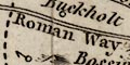
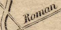
Roman Road to Sarumand a road in the north west of the county, aligned with Salisbury and Silchester,is labelled:-
Roman Way
Labelled north east of Exton is:-
Stevens Castlewhich is probably a tumulus on the north part of Stephen's Castle Down, Upham parish.
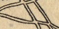
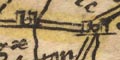
A network of roads is drawn over the county using double lines. These might be continuous or dotted, presumably for fenced or unfenced roads. Main roads are not distinguished. Most of the Ogilby routes are shown, but not completely; there are other main routes as well.
Destinations outwith the county are labelled, eg:-
to London
From Salisbury
From PoolAt least one road junction is named (in Wiltshire):-
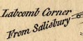
Labcomb CornerSome roman roads are labelled:-
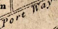
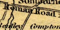
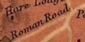
Port Way
Roman Way [Salisbury-Winchester]
Ikenield WaySilchester roman town is drawn with a circle, outer ring, and hachuring, labelled in lowercase italic text:-
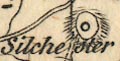
Silchester
A tumulus is labelled:-
Canuts Barroweast of Upper Wallop. Just there to fill space?
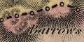
If you have seen them before, on other maps, you will recognize three little haystack shapes:-

(plate 21 scroll 5 mile 56)as a drawing of the Popham barrows. If you haven't seen these before you may not be convinced!
Some roman roads are labelled, eg:-
Roman Road from Sarumon the route from Winchester towards Salisbury near Broughton; and:-
Roman Wayon the route aligned with Silchester and Salisbury to the north of Andover; and:-
Ikineld Wayrunning NW from Winchester.
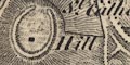
Silchester, where there are the remains of a roman town, is specially marked with its circle surrounded by a ring of ?hachures.
Hillocks a mile beyond Amesbury on the way towards Stonehenge are labelled:-
Burrows or Small HillsAn array of shaded blocks portrays a henge:-
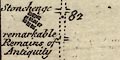
Stonehenge remarkable Remains of Antiquity
Three roads have dotted lines; the Portway, the roman road east from Winchester, and the road south from Silchester.
Roman roads are clearly marked and labelled:-
Roman Road from Old Sarum
Port Way
Roman Road [Winchester towards Silchester]
Icknield WayIt would be worth comparing these claims with what is accepted nowadays.
Silchester has its roman town marked by a ring of ?hatching with a central block.
Some roman roads are lebelled:-
Port Way
Ikenield way
Roman Way [Sarum-Winchester]At the end of one road is a circle surrounded by a ring of dots, for the roman town:-
Silchester
Roman roads might be labelled, eg:-
Port Way Roman Roador:-
Port Wayeand:-
Roman Road from Sarumgoing to Winchester.
A number of barrows and hillforts are labelled, eg:-
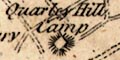
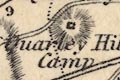
Quarley Hill Camp
3 Barrows [NE of Winchester]
Dunbury Camp
Woolbury Ring
Kents or Canutes Barrow [NE of Up Wallop]
Some roman roads are shown, labelled:-
Port Way
Icknield Way
Roman WayThe last is that west from Winchester; the usage of capital letters at this period does not allow the assumption that this is a road name.
A roman road might be labelled, eg:-
Roman Road [the Portway]
Roman Way [the Icknield Way]perhaps named, eg:-
Fosswayin Somerset.
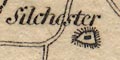
Silchester is marked by a block in a hachured ring, the roman town.
A very straight road is drawn aligned with Silchester and Salisbury, from about Ewhurst to near Quarley, labelled:-
Roman RoadThe main road from Winchester to Popham, continued as a small road towards Silchester to about Sherbourne, is labelled the same.
Oval outlines etc mark Danebury hillfort, labelled:-
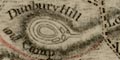
Dunbury Hill and Campon Longstoke Hill.
Quarley has two ovals and dots inside, labelled:-
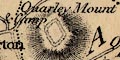
Quarley Mount and Camp
Tidbury Hill Camphas nothing except the label. Etc.
Silchester roman town in drawn in outline with the supposed street pattern. An outside to the east:-
AmphitheatreA number of roman roads are labelled, eg:-
Port Way
Roman Road from Old Sarum to Winchester
The rectangular outline of:_
Porchester Castle is drawn, with buildings within, and the great tower obvious. Somewhen about this period the fort was in use as a Prisoner of War camp for captured French.
At least two hillforts are labelled:-
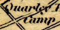
Quarley Hill Camp
Dunbury Camp
Some roman roads are labelled, eg:-
Roman Road from Sarumto Winchester.
The Portway is clearly drawn, but not labelled.
Numerous antiquities are noticed, eg:-
Tumuli [on St Catherine's Hill]
Barrow [hatched circle, SE of Yateley]
Seven Barrows [N of Litchfield]
Ladle Hill [hillfort?]
Devils Ditch [SW of St Mary Bourne]
Harrow Way [N of Overton]
Caesars Camp [SW of Aldershot]
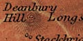
Deanbury Hill [hillfort]
Kent Barrow
Tumulus [SW of Crawley]
Ancient Entrencht. [near Toothill]Some less ancient sites are labelled in english black letter, eg:-
Priory (Remains of)to the south east of Southwick. Hillforts are drawn by rings of hachures, tumuli by little circles of hachures.
Quite a number of roman roads are noticed, eg:-
Roman Roadlabelled WSW of Freemantle Park, and more helpfully:-
Roman Road from Old Sarum to Winchester [S of Kings Sombourne]
Roman Road to Porchester [N of Morestead]The road is indicated by an embankment of hachures, perhaps partly including existing modern tracks or roads. One interesting example is seen where the fairly straight road from Winchester to Otterbourn turns away to the west. There is no track or embankment, but along the line to the south is labelled:-
from Bitternewhich was roman Clausentum.
The road west from Winchester is labelled:-
Roman Road from Old Sarumand the road on a line between Silchester and Sarum is labelled:-
Port Way / Roman Road
Some roman roads are labelled, eg:-
Roman Rd.on the road between Winchester and Popham Lane, aligned with Silchester.
Roman Roadon the road west from Winchester, roughly aligned with Old Sarum.
There is a rectangular outline for a hillfort within the hill hachuring for:-
Quarley Hill Camp
circle, labelled:-
Danebury Hill / campfor the hill and the hillfort.
Tumuli are drawn by a circle of hachures, singly or in groups, eg:-
Barrows [Martin parish?]
Tumuli [lots, Petersfield Heath]
Barrow [Hartford Bridge Flats]A larger ring of embankments drawn by hachures marks a hillfort, eg:-
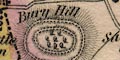
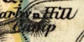
Bury Hill
Deanbury Hill
Ladle Hill
South of Kingsclere is labelled:-
Roman Road to Silchesterand at the village the outline of the roam town, thew walls that still stand now, are drawn. South of Crondall, Upper Swanthrop, is a square labelled:-
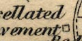
Tessellated Pavementsign of a roman villa.
Antiquities are not much noticed, but see:-
Quarley Hill Campmarked by a square symbol on the hill.
Some roman roads are labelled, eg:-
Roman Roadsouth of Stockbridge, crossing the Test near Kings Somborne.
See:-
Crawley Barrow
Running west from Winchester towards Broughton is a:-
Roman Road
A hillfort might be drawn by a double dotted ring, and labelled, eg:-
Deanbury HillOn Toot Hill there is:-
Anct. Entrnt.And tumuli are noticed by small circles, as:-

North east of Horndean.
Some roman roads are labelled, eg:-
Roman RoadFor example between Silchester and Salisbury. Also labelled is:-
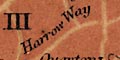
Harrow Way
Some hillforts are noticed, eg:-
Qaurley Hill Campand between Winchester and Salisbury a:-
Roman Road
A number of antiquities are shown on the map, marked and/or labelled. This includes some doubtful 'roman camps' for hillforts and perhaps too many 'Cromwell's camps'. Examples:-
Quarley Mount and Camp [hillfort]
Keats or Canutes Barrow
Camp [Danebury hillfort]
Roman Camp [Old Winchester Hill earthwork]
Amphitheatre [W of Silchester]
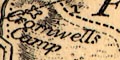
Cromwells Camp [SE of Winchester]
Oliver Cromwell's Camp [W of Winchester]There are also roads labelled:-
Roman Roadas just south of Dibden which may or may not be that. And roman roads like:-
Port Way
On Quarley Hill there is a double dotted outline of a hillfort. There are others, at Old Winchester Hill for example, and, south east of Ashley this symbol is labelled:-
Anct. EntrenchmentSome tumuli are noticed, for example:-
Seven Barrowsnorth of Litchfield, and, north west of Botley a circle labelled:-
Tumulus
Some roman roads are labelled, eg:-
Roman Roadsouth of Litchfield, part of the route from Silchester to Sarum. To the West of Winchester again:-
Roman Roadon the route from Winchester to Salisbury.
North of Farley Chamberlayne is labelled:-
Ancient Entrenchment
On the Hampshire/Surrey border west of Aldershot is a rectangular outline labelled:-
Caesar's Camp
Marked by a circle north east of Middle Wallop is a tumulus labelled:-
Kent BarrowMarked only by hill hachuring but labelled for the hill and hillfort is:-
Quarley F. & HillNear Abbotts Ann is a double dotted circle, unlabelled, which is Bury Hill hillfort.
Segments of roads lined up between Silchester and Old sarum are labelled:-
Port Way / Roman RoadThe road east of Winchester is labelled:-
Roman Road
Some hillforts are marked by a dotted circle, labelled, eg:-
Deanbury Hill
Old Winchester Hill
A roman road, west of Winchester, is labelled:-
R o m a n R o a dAnother is labelled similarly, running south west from Silchester, passing north of Andover, ie the Portway.
See:-
Kent Barrownorth of Middle Wallop, but little else is noticed.
With no symbol there is a label:-
Kent Barrowsouth of Andover. The nearby hillforts of Danebury and Quarley are not noticed.
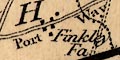
A stretch of road north of Farleigh Chamberlayne is labelled:-
Roman Roadon the line between Winchester and Salisbury. South of Kingsclere another piece of road is labelled the same, on the route from Silchester to Sarum.
A circle of slightly bolder hachures is used to mark some hillforts, labelled, eg:-
Deanbury Hill
Old Windmill Hill
Quarley HillThere is one:-
Roman Roadshown from Winchester towards Kings Somborne.
On Butser Hill there is a diamond symbol labelled:-
ROMAN CAMP
Tumulus [english black letter]on Yateley Common
A roman road, for example:-
ROMAN A.34 ROADcoming into Winchester from Worthy Down.
