
 Return to list of Features

NB: typical illustrated examples are described, NOT ALL examples.
absence of evidence is not evidence of absence
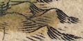
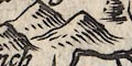
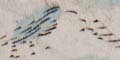
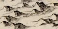
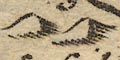
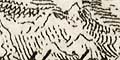
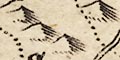
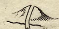
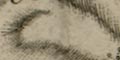
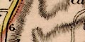
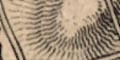
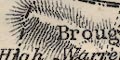
Some hills are shown by semicircular, scallop, shapes, perhaps piled up.
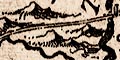
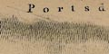
Snawedonis a splendid example, and notice Clee Hill, from which flow Severn and Dee on the welsh border.
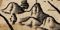
Relief is mostly ingnored. The heights of Dartmoor and Bodmin Moor are labelled, also the Cheviots, Cumbrian mountains, and some mountains in Wales, and in Scotland where they are drawn in nobbly elevation.
No relief is shown in Hampshire.
Some relief is shown on the map by hillocks. The Hogs Back near Guildford is shown by a row of hillocks; the Mendips in Somerset are drawn similarly. No relief is shown for Hampshire.
The map has hillocks to indicate relief, but none in Hampshire.
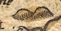
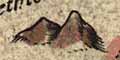
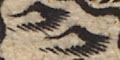
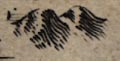
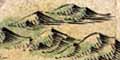
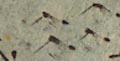
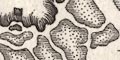
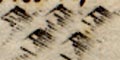
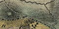
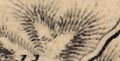
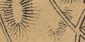
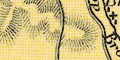
Hills are indicated by little hillocks. These are partly grouped, though it is not easy to interpret what they mean. Some hills are made steeper than others; some hills are named.
Relief is indicated by hillocks, tinted with a patch of pale brown. These have not been looked at in detail.
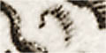
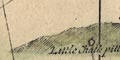
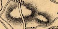
Some relief is shown by large hillock symbols. Scotland and Ireland have ranges of mountains. Wales has some but not where you'd expect. And there are odd hills here and there. A large hillock north of Salisbury is probably:-
Salisbury Plain
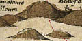
Painted hills, green humps, suggest some relief. There is a group in the middle of the county, north of Winchester, south of the River Loddon system, which are Hampshire Downs. And a group north of what is probably Petersfield, part of the South Downs.
A few little hillocks are drawn to suggest relief, fitted in between place names. They are not very helpfull? There is a range of hills representing the South Downs, and another the Berkshire Downs north of the Kennet, etc.
A group of hillocks continues the South Downs into Hampshire from the east. Magdalen Down (?) east of Winchester is suggested by another group.
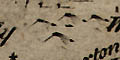
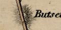
Hillocks, shaded to the east, indicate relief. Few hills are labelled, but see:-
Butser hill
toothill
Hillocks are drawn to indicate relief in a very few places; mountains in Wales, the Pennines, mountains in Scotland and Ireland. There is a chain of hillocks for Salisbury Plain, and a group in Cornwall, but little else.
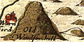
Relief is mostly ignored. There is a hill:-
which is probably 'Old Winchester Hill' near Clanfield.
Relief is suggested by hillocks.
which are grouped in various ways.
Scattered on the map are a few hillocks, shaded to the east, suggesting relief. Space is very limited for this information. Judging from Hampshire the representation of the shape of a county is not reliable! There are one or two hillocks sort of where the South Downs might be. In other parts of the map there is some suggestion of the Penine Way and of hilly regions in Scotland and Wales.
Relief is mostly not shown - tho' this is part of Drayton's objectives. Presumably there are no hills in Hampshire that he feels worth drawing. Some hills are mentioned in his song.
Hillocks are used to suggest relief. On this small scale the relief is somewhat notional. Perhaps it is reasonable to recognise parts of the:-
South Downs
North Hampshire Downs
No relief is shown. No beacons are shown.
A couple of hillocks are drawn to indicate relief ... just to show willing?
Groups of hillocks, some with shading to the east, indicate some relief. Ranges of hills between Christchurch and Ringwood, north of Lyndhurst, north east of Petersfield, and north of Winchester, are shown. This is not a good guide to the shape of the county. No hills in Hampshire are labelled.
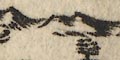
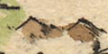
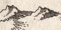
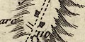
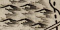
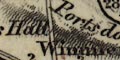
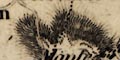
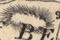
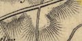
The map shows relief by hillocks shaded to the east. These have a slightly rugged shape, not just simple mounds; some are bigger than others. Hills are grouped. A line of hills sometimes extends into a microscopic landscape drawing with bushes and trees, eg west of Ringwood. Hills might be labelled, eg:-
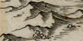
PORTESDOWN
Dunbury hill
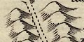
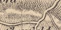
Relief is indicated by groups of hillocks shaded to the right. The hillocks are sometimes quite knobbly, for example in the range running eastwards from Winchester, Magdalen Down.
Dunbury hillis labelled against a range of hills north of Nether Wallop.
Relief is suggested by hillocks, shaded to the east. Hills are grouped.
none
There is some indication of relief, shown by hillocks. Examples on the Dorset border west of Ringwood, around Hale, the Sussex border east of Clanfield, and near Popham etc. There is no serious attempt to portray the relief of the county.
Portsdown is drawn as a row of hillocks behind Chichester.
A few hillocks indicate hills, but they do not appear to be a serious attempt to depict relief.
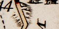
Mostly as original (and hard to compare!)SE of Clanfield, two small hillocks are added, one with a windmill, a post mill, on top.
Only the line of Portsdown is shown on the mainland drawn in persepctive with slope lines and chalk pits. On the Isle of Wight the great ridge from east to west is drawn as well as a scatter of hillocks allover.
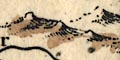
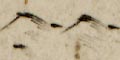
Relief is indicated by hillocks, a simple hump shaded to the east. These do not seem to be clumped in a meaningful way, but are scattered about as decoration.
Little hillocks are drawn, shaded to the eastward, to indicate relief. The hillocks are somewhat grouped. A few hills are named, eg:-
Dunbury hill
Butterhill
Very few hills are drawn; groups of hillocks east of Winchester, and by Quarley. The latter labelled:-
Quarley & Hills
Butser hillis labelled but no hill shown.
There are some tree symbols for woodland and a few hillock symbols for hills. They look to be little more than decoration.
No relief is indicated.
There are a few scattered hillocks suggesting relief. They are more decorative than informative.
No relief is indicated.
Some relief is indicated by drawings of hills, in the style of hillocks but using shading lines like hachures. There might be a label, eg:-
Post Downs [Portsdown]
Bevose Hill [at Southampton]
Highland of Ballard [south of Poole]and north of Chichester there is a large hillock with a road in a valley:-
Large White Way up the Hillwhich was presumably a sea mark.
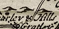
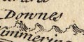
Hills are indicated by little hillocks, which may be grouped into ranges of hills. The only label is:-
Downesnear Portsey.
Relief is not shown.
Groups of knobbly hillocks indicate the hills west of Winchester to the Wiltshire border. Other high ground is not shown, except for Malwood Castle set on a hillock
The map shows no relief.
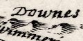
Hillocks are used sparingly, in groups, to show areas of downland. There is a group south east of Winchester; a small group in the New Forest; a ridge north of Micheldever; and north of Portsea is a line of hillocks labelled:-
Downes
Relief is indicated by bold knobbly hillocks shaded to the east. It is not clear what is being depicted.
There are a few hillocks in the New Forest to suggest relief. In the hillier parts of Hampshire, except for two hillocks near Beauworth, there is no indication of relief.
Hills are drawn realistically, in perspective, but exagerated. Do not trust the drawings as a guide to Hampshire's landscape.
Relief is shown by groups of hillocks shaded to the eastward. The correspondence beween hill groups and high ground is not easy to follow.
Small shaded hillocks, seem just to be filling space decoratively. They are scattered about liberally.
Relief is indicated by little hillocks, shaded to the east.
Overall they give little impression of the 'bones' of the county, they are just a clutter of symbols. There is some variation in symbol size, and some groupings of the slightly larger symbols, for example around Wherwell, and perhaps for Portsdown. Perhaps separated out, viewed by themselves they may make more sense.
Little hillocks, scattered liberally, are used to indicate relief.
The appearance of the coast line is suggested by hachuring for low slopes, or jagged rocks shapes for cliffs. These might be labelled, for example the white chalk cliffs:-
Hautes Colines Blanchesbetween the Needles and Freshwater Bay on the Isle of Wight. Stubbington Cliffs are labelled:-
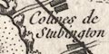
Colines de Stubbington
Groups of craggy hillocks, shaded to the east, indicate hills. Not many are labelled, but see:-
Colinesnorth of Chichester, west of West Dean. The hill where Castle Malwood sits in a valley shows some of its form by hachures.
Relief is indicated by small hillocks shaded to the east. However, it is difficult to disentangle any pattern of hillocks; they seem to be scattered, equally with tree symbols, all over every empty space in the county area, and across the county borders. There is some labelling, eg:-
Buckholt Hills
Chilton Downs
Winters Hill [N of Bishops Waltham]The labels, if you find them, are more helpful than the symbols.
The hillock symbols on the Bowles and Sayers map are slightly larger, and slightly more numerous? than on the Kitchin map; the hillocks are tinted.
The hillocks give no better impression of the shape of the county, and appear, as on many maps, just to be filling space! The overall impression could even be judged to be misleading.
Both maps use hillocks engraved with shading to the east. Bowles's hillocks are larger and a little more numerous. Their tinting is crude and doesn't clarify anything. Magdalen Down has lost its hillocks; the downland to the west of Winchester have gained some. Some of Bowles's hillocks interfere with other features.
Relief is suggested by little hillocks, shaded to the east, perhaps in groups. A few are named, eg:-
Black Hill [N border near Whitsbury]Some of the groups of hillocks are in rows, with a ridge road on top, for example from Colemore to Petersfield.
A down might be labelled, without a hill symbols, eg:-
Basingstoke Down
No relief is shown on the map.
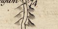
(plate 21 scroll 6 mile 74)Some relief is shown on along the roads by hillocks. Although the hillocks might be grouped along the road, as at 73-74m. from London just beyond Stockbridge, I would not interpret this as meaning a ridge route.
Further towards Weymouth, about 125-127m. from London, beyond Dorchester, a whole row of hillocks is labelled:-
Ridgway Hill
Small hillock symbols, shaded to the east, indicate relief; just what is indicated is not clear as the symbols are lost in the overall muddle of features. Some hills are labelled, eg:-
Winters Hill [nr Alresford]
Buckholt Hills
Bramble Hill [S of Fritham]On the London to Portsmouth road, NE of Petersfield is labelled:-
Gravel Hill
Relief is suggested by groups of hillock symbols, shaded to the east. Although these are in groups it is not easy to follow what is being plotted. None seem to be labelled.
Hill hachuring is used to mark the eastern side of the Test Valley, up which the canal climbs, with some hillsides to the west. A hill is marked:-
Midla Hillby Lakeford.
Hills beside the road are drawn by hillocks. These might be under the road presumably indicating descents and descents, which are not differentiated; or a whole series under the road indicating a ridge way:-
or a whole series on either side the road indicating a valley route:-
Some hills are labelled, eg:-
Scratchbury Hill
Cotley Hillboth in Wiltshire, and
Anstrow Hillwithout any hillock.
A ridge of hill from Greywell north to Rotherwick and Turgis is shown by hachures. The canal loops around much of this, but a tunnel is also drawn through the ridge at Greywell. Other hills are shown to the south of the canal between Crookham and Aldershot, and more in Surrey.
No relief is shown.
As well as drawing the appearance of the coast line, and the elevations in the coastal views, high land might be shown by hill hachuring. The ridge of hill on the Isle of Wight is marked this way.
Relief is not much shown on these roads. There is a little hachuring beside the road, eg:-
(page 103/104 scroll 2 mile 43-44)at Froyle which suggest it is on a hill top.
A label might also suggest an upland route:-
(page 103/104 scroll 3 mile 61)
Longwood Down
Small indistinct hillocks shaded to the east signify hills. These are grouped, but do not depict the bones of the county at all well or reliably. The road from Petersfield towards Alton is drawn running along a ridge of hills:-

No relief is shown. But a few hills are labelled, eg:-
Tidbury Hill
Ports Down
The map indicates relief by little hillocks, shaded to the east. These are grouped, a little, but do not clearly portray the shape of the county. There are groupings near the county boundary Liphook-Petersfield and Hale-Bramshaw, for example.
A few hills are labelled, eg:-
Popham Beaconbut no symbol for a beacon, and:-
Basingstoke Downand:-
Black Hill
Knowl Hillon the Wiltshire border.
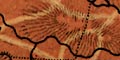
Relief is indicated by hill hachuring for ranges of hills, isolated mounds, scarps, etc. Some of these are labelled, eg:-
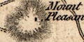
Mount Pleasant
Portsdown
Weavers Hill [E of Greatham]
Bare Hill [SE of Andover]A hill name is used as the name for a stretch of road:-
Gravel Hillat miles 51-53 on the road from London to Portsmouth, NE of Petersfield.
A hill might be named without being drawn, eg:-
Tidbury HillSE of Longparish and:-
Black Downin the New Forest. Some hill names appear as settlement names, eg:-
Gilbert Hill [S of Upham]
Cuckow Hill [S of F'bridge]
Relief is indicated by hill hachuring. Notice the valley of the stream running south from Rowner to the Solent: prettily engraved. Some hills are labelled, eg:-
Portsdown
Idsworth DownAlso notice the hachuring along the coast line by Stubbington, where the coast is a little steeper.
No relief is indicated.
Some relief is shown by hill hachuring. For example, the downs near the Wiltshire border by Amesbury, and the long ridge of Portsdown. The relief shown is neither an overall guide to the shape of the county, nor a consistent guide to problems the traveller might meet.
No relief is shown in Hampshire. In Somerset the Mendip Hills are drawn by hachuring and named; in Wiltshire some of the edge of Salisbury Plain is hachured.
No relief is indicated.
Relief is indicated by hill hachuring. This shows highs and lows effectively but does not clearly indicate how high is high. Where hachuring is crowded you have the same problem as with contour lines, in knowing which way is up, though it can be a little easier with hachures. Some downs and hills are labelled, eg:-
Odiham and Warnborough Downs
Froxfield Hangers
Sydmonton Hill
BUCKHOLT HILLSAt least one valley is labelled:-
Longwood Bottom
Some land relief is shown, presumably where this will help the mariner. The hill might be labelled, eg:-
Portsdown Hill
Hill hachuring is used to suggest the landform immediately behind the coast line. Other relief is not shown, except:-

PORTS DOWNdrawn behind Portsmouth Harbour. A few trees suggest woodland; and a post mill shows a windmill.
Relief is suggested by crude hill hachuring, outlining the chalk downland, which is marked by 'grass' symbols. There is some labelling of hill areas, eg:-
The WESTERN DIVISION of the CHALK HILLSfor the North Hampshire downs.
Elsewhere on the map is:-
The EASTERNand:-
SOUTHERN DIVISION of thesuggesting that this map should be seen with an accompnying east sheet.
A valley is named, the Wey's valley south of Alton:-
VALLEY of FARNHAM
Relief is indicated by hill hachuring. What is shown is what concerns a mariner at sea, ie what is a useful land mark. So the ridge of:-
PORTSDOWNis drawn, with a:-
Clump of Trees
Wind Millmarked in position.
The map shows neither rivers nor relief.
No relief is shown on this topographical map.
No relief is shown.
relief is not much noticed, what is shown is drawn with hill hachuring.
Hind Head Hill
Ports Downare named but have no hachuring or other symbol.
Butser Hillis shown by hachures with the road going across a flank.
Relief is not shown, and little is implied by labels except incidentally, eg:-
Quarley Hill camp
Gilbert Hill [NW of B's Waltham]
Filmer Hill
No relief is shown.
Relief is indicated by hill hachuring, which, disentangled from other features, is moderately successful at giving a local impression of landscape; it does not show the shape of the country as a whole. The relationship of rivers to valleys, and roads to ridges, is often very clear. Some hills are labelled, eg:-
PORTS DOWN
Butser Hill
Bere Down
Toot HillAs well as hills some valleys are labelled, eg:-
Hollywell Bottom [W of Kingsclere]
No relief is shown on the map.
Relief is not indicated
No relief is indicated by symbols, though there are some labels:-
Ports Down
Gravel Hillthe latter engraved alongside the London to Portsmouth road.
No relief is shown.
Some relief is indicated by hill hachuring. This shows up fairly well among the other detail on the map, but does not give a clear picture of the bones of the county. Some hills and downs are labelled, the latter may not have any hachuring. Eg:-
Deanbury Hill
Breamore Down
Honour Hill [W of Lower Wallop]
Portsdown Hill
Oxenborne Down [N of Clanfield]
No relief is shown.
Relief is not indicated.
Relief is not shown.
There is still no relief drawn but:-
Danebury Hillis labelled as a hill.
Relief is indicated by hill hachuring. Like all hachure systems this might give a local sense of where slopes are, but gives no overall sense of the county's shape. Locally dramatic features do not always show up; where is the hanger from above Oakhanger village round to Selborne? The hachuring is much better than some other maps of the period, and care is taken not to obscure other features and labels. Some hills are labelled, eg:-
Codington Hill [S of Kingsclere]
Ports Down
Worthy Down
Buckholt Hills
Buster Hilland some valleys are labelled too, eg:-
Bedlam Bottom [SE of Kings Worthy]
Halcom Bottom [SE of Chilcomb]
Although there is no symbol showing relief, some hills are labelled, eg:-
Quarley Hill
Relief is shown by hill hachuring; the marking of relief has not a high priority. Some hills are labelled, eg:-
Portsdown Hill
Gilbert Hill
Tatchbury Mt.
Some relief is indicated by hill hachuring. The South Downs and North Hampshire Downs are suggested amongst a few other hills.
Relief is indicated by hill hachuring, which gets lost amongst the other stuff of the map, and adds its own degree of confusion. Hills are not labelled generally, but some are implied by settlement names, eg:-
Rose Hill Pla.
Filmer Hill
Swain's Hillnone of which are near any hachures.
Quarley Hillis clearly labelled, but the hachures do not show a detached hill top.
No relief is shown.
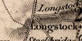
Hill hachuring is used to suggest relief. There is some labelling, eg:-
Magdalen Hill
Longstock Hill
Portsdown Hill
No relief is shown by the map.
Relief is shown by hill hachuring. While this is attractive to the eye, it does clutter up the engraving, and as it is done, in narrow ridges, doesn't provide an overall impression of the land form. A few hills are labelled, eg:-
Quarley Hill
Longstock H
Bridgers Hill [no hachures, NE of Liss]
Toot Hill [or is this the settlement?]The last points up a general problem with labelling. English places names for settlements often arise out of geographic features. How do you know what is a name for a feature, and what for a settlement? And sometimes: what name is just a description of the feature, 'wooded hill', and what is a name 'Wooded Hill', when there is a tendency to label everything with leading capital letters.
A little relief is indicated by hill.hachuring, but not much, and not enough to give a sense of the shape of the county. Hills are not labelled (?).
Relief is not indicated.
Relief is not indicated.
No relief is indicated.
A limited amount of the county's relief is shown by hill hachuring; it does not provide a reliable view of the bones of the county. None of the hills seem to be labelled; no beacons are noticed.
Relief is indicated by hill hachuring, which in some places gets lost in other detail, and elsewhere confuses other detail. Some hills are labelled, eg:-
Longstock Hill
Catherington Down
Tower Hillthe last W of Over Wallop.
At least one 'pass' is noticed and labelled:-
Hampshire Gapbetween Quarley Hill and the hills W of Over Wallop.
Some relief is shown by hill hachuring, for example in the north of the county, and the edge of the South Downs in the east.
Relief is shown by hill hachuring, and might be labelled, eg:-
Portsdown, 447
Butser Hill, 917The figure is a height in feet. A few other hills are named, eg:-
Old Winchester Hill
St Catherine's Hill
Some hills are shown by hill hachuring, and labelled, eg:-
Portsdown Hillalong which visible features on the ridge are noticed - Nelson's Monument, Chalk Pit, Fir Garden, Portsdown Mill, etc.
No relief is shown.
Some downs are labelled as places of hunt meets, eg:-
Northington Down
Relief is not shown.
Some relief is indicated by hill hachuring, but this is easily lost in the busy detail of the map, and gives no overall idea of the shape of the land. Some hills are named, eg:-
Old Winchester Hill
Honour Hill [by Upper Wallop]
Tatchbury Mt.
Beacon Hill [Farley Chamberlayne]Beacons are hardly noticed except as an accident of the hill name.
Relief is indicated by hill hachuring, perhaps making a serious attempt to show the structure of the county. An example:-
on the Blackwater to Hartfordbridge road in the northeast of the county.
Relief is indicated by hill hachuring, with several of the hills or groups of hills labelled, eg:-
Borroughclere Hill
Weavers Hill [NE of Liss]
Winchester Hill [Old Winchester Hill]
Portsdown Hill
Quarley Mount
Mount Pleasant [N of Sherfield English]
Duckholt Hillswhere Buckholt Forest should be marked and labelled.
Again there are place names on this map which may not occur on other maps.
Other hill names might be impied by settlement names, Filmer Hill for instance.
Some relief is indicated by hill hachuring, and a few hills are labelled, not all with hachures, eg:-
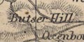
Butser Hill
Quarley Hill
Hampton Ridge
Worthy Down
Relief is indicated by hill hachuring. Instead of the narrow ridges drawn by some map makers, the hachures outline areas of higher land. Buried in other detail this is not as successful as it deserves to be. Some hills are labelled, eg:-
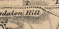
Magdalen Hill
St. Catherines Hill
Easton Down
Flower Down
Compton Down
Worthy Down
Twyford Downaround Winchester.
Near Exton thre is a hill named:-
Beacon Hillelsewhere I have seen little sign of beacons.
A limited amount of relief is indicated by hill hachuring. It is so limited as to be misleading. The significant, to building the railway, hills between basingstoke and Winchester are not indicated at all, except that there is a 'tunnel', only one, enroute. Something of relief might be deduced from some labels, eg:-
Popham Beacon
Thorney Down
Worthy DownAt Portsmouth the prominent ridge of:-
Portsdown Hillis drawn by hachures and labelled.
Near Basingstoke there is a hill with a hillfort at Winklebury.
Relief is suggested by hill hachuring, but it does not give a clear summary of the bones of the county. Considering this is a geological map, this is a pity. Some hills are labelled, eg:-
Deanbury Hill
Ports Down
Relief is not indicated.
No relief is shown.
Some relief is indicated by hill hachuring. The information is lost, and adds to confusion, on these busy maps. Some hills are labelled, eg:-
PORTS DOWN
Toot Hill
White Hill
Owslehurst Downbut these might not all have hachures. Hachuring might show the relationship of a road to a ridge very clearly, for example a hill track west of Over Wallop.
A valley might be labelled, eg:-
Long Valleywest of Aldershot.
Some relief is indicated by hill hachuring.
A little relief is indicated by hill hachuring of individual prominences or ranges of hills, W of Winchester for example. Some hills are labelled, eg:-
Butser Hill 917
Westbury Hill
PortsdownA hill might be labelled with its height. A note under the scale line states:-
Heights in feet.A hill might be indicated by label alone, eg:-
Toot hill
Relief is indicated by hill hachuring. In Hampshire this does not give a reliable picture of the shape of the county. A narrow ridge is part of the South Downs, extending west from the end of that there is an escarpment which looks to be facing the wrong way. Etc. It is not convincing.
Some relief is indicated by hill hachuring, but this on this small map few hills are shown, some labelled, eg:-
Portsdown Hill
Butser Hill
Siddown Hill
Relief is indicated by hill hachuring. This is neatly engraved and suggests various ranges of hills in the north of the county, around Winchester, parts of the South Downs, etc. Some hills are labelled, eg:-
Longstock Hill
Catherington Down
Toot Hill
Magdalen HillThe last having no hachures. It is difficult to read amongst the hachuring, but there appears to be an altitude given at:-
Bulser Hill 91[7] F[t]The spot height for Butser Hill is 270 metres = 885 feet. 917 feet is nearly 280 metres.
Relief is shown by hill hachuring. Some hills are labelled, eg:-
Quarley Hill
Longstock HillSome downs are labelled, eg:-
Broad Halfpenny Down
Corhampton Down
There is a little hill hachuring to indicate relief, and some labelling, eg:-
NORTH DOWNS
Knap Hill
Mt. Pleasant
No relief is shown.
Relief is indicated by hill hachuring. Few of the hills are labelled.
Some relief is drawn by hill hachuring. In Hampshire, the southern scarp of the South Downs is shown north of Havant, and the northern edge of the North Hampshire Hills are shown south of Basingstoke.
Some relief is indicated by hill hachuring. While the shape of the county is not well described by these symbols, at least the:-
South Downs
North Downsand the edge of Salisbury Plain, are clearly located. Portsdown in missing.
No rivers, relief or woodland is shown.
Only very few non railway details are shown, eg:-
SALISBURY PLAINlabelled and drawn by a shaded red area. A bold dotted circle is labelled:-
STONEHENGEIn Hampshire the:-
NEW FORESTis labelled, but there are no tree symbols.
Relief is shown by layer colouring, printed without contour lines at the edges. The layers do not have equal vertical intervals. The table of symbols on a preface page explains:-
Heights in feet
under 100 [green]
100 to 250 [yellow]
250 to 500 [pale orange]
above 500 [orange]The bold colours give the road maps a jolly appearance. Hills, downs, etc are generally not labelled.
Relief is not generally shown on the map. But there are some indicators. Some sort of hachuring is used at the Devil's Punch Bowl, and at:-
Portsdown Hillwhich is labelled. Here and elsewhere a steep hill might be marked with an arrow, pointing up hill. Some other hills are labelled, eg:-
WINDMILL HILL [by Chalton]
BUTSER HILL
Relief on the maps is shown by contour lines printed in orange. The vertical interval is 50 feet, the 50 foot and then each 100 foot contour are labelled. Labelling is along a contour line as near upwards as can be for easy reading: this means that the number is not 'up' uphill, and cannot inform the user which way is up through the series of contours. Contours provide a real plot of the lie of the land, but, as with most contour line systems it is not easy to see the shape of the land from the contours, except where they happen to be close together, perhaps helped by a spot height of a hill summit, or a river in its valley:-
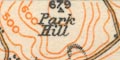
Park Hill / 670
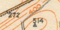
514on Broadhalfpenny Down
It is hard to follow a contour round the map till a label is found, by which time you've probably lost where you started.
Spot heights are given by a figure, with the spot marked by a dot in a triangle. Spot heights on roads are a figure by a dot.
Johnston 1920, questions after his paper, Major General Lord Edward Gleichen:-
Do I understand you to say that these 'popular' one-inch maps are approved of for military purposes? It occurs to me that one does not grasp the lie of the ground anything like as quickly .... does not differentiate hills and valleys ...The stonewall reply was:-
It has been accepted by the War Office.Printed at the bottom of the map is:-
The Altitudes and Contours are given in Feet above Ordnance Survey Datum (Mean Sea Level.)
Contours surveyed on the ground, 50', 100', 200', 300', 400', 500'. 600', 700', 800'., Other contours interpolated and only approximately correct.Johnston 1920:-
... it will be noticed that the contours, instead of being at 100 and 250 feet apart, are now uniformly at 50 feet vertical interval. The interpolated contours have been engraved from the 2-inch hill drawings and from spot levels. The old contour lines, viz. 50 feet, 100 and every 100 feet up to 100, and every 250 above that height, had been previously surveyed on the ground.
No relief is shown.
Relief is not marked by any symbol, but is indicated by altitude figures along the line and occasionally in the surrounding countryside. A height might be labelled, eg:-
WORTHY DOWN 404'
St Catherine's Hill 328'Other relief data is given with the railway line.
The railway is a bold line up the page: stations clearly marked and labelled in underlined upright block caps, eg:-
WINCHESTERThe distance of each station from London, Waterloo, is given at the side of the map. The time from station to station is also given (one assumes for a non-stop train). For eaxmple Winchester is:-
66 3/4 MILES FROM LONDON
12 MINUTES MICHELDEVER TO WINCHESTER
4 MINUTESto Shawford.
Features of the line, embankments, cuttings, tunnels, bridges are shown and sometimes labelled, eg:-
deep Cutting
Bridges overAlso notice:-
Railway Worksdrawn with a mass of sidings and sheds at Eastleigh.
Altitude figures are given along the line. A gradient diagram shows the altitude of the line as a graph alongside the strip maps. The diagram is annotated, eg:-
LINE LINE FALLS 1:100
LINE RISES STEEPLY 1:80
LINE LEVELThere are comments about the speed on the journey, eg:-
Speeds: The slight rise in level through Basingstoke does not affect our speed, and we bowl along at 60 m.p.h. increasing on the down gradient through Overton ... ...
The map is made with layer colouring, different enamels, to show relief. The vertical interval is not given, but, at a guess, is about 50m. There are four layers: green, plae green, cream, yellow. The map provides a very clear impression of the 'bones' of the county; Hampshire Downs, South Downs, Wealden Edge, North Hampshire Downs, etc, with the various river basins.
relief |
|||||||||||||||||||||||||||||||||
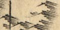
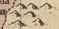
| hillocks |  |
|
|
|
|
|
|
|
 |
 |
|
|
|
|
|
|
|
|
|
|
|
|
|
 |
|||||||||
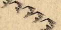
| hachuring |  |
|
|
|
|
|
|
|
|
|
|
|
|
|
|
|
|
|
|
|
|
||||||||||||
Prescott, Roger: 1983: Chalk Grasslands, Hampshire's Countryside Heritage: Hampshire CC:: ISBN 0 900908 78 5
