
 Return to list of Features

NB: typical illustrated examples are described, NOT ALL examples.
absence of evidence is not evidence of absence
Windmills are drawn on the map, for example two on Portes down. The mills are post mills with four sails.
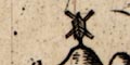
A fine post mill is drawn on a hillock W of Chalton.
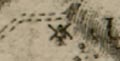
A circle with paddles is drawn in the Bourne Rivulet between Hurstbourne and St Mary Bourne.
A post mill is drawn at Clanfield.
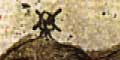
There is a symbol taken to mean a water mill; a circle with radiating spokes - a wheel and paddles? This is on the Bourne Rivulet between St Mary Bourne and Hurstbourne.
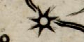
A fine post mill is drawn at 'Katerington'.
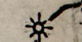
A water mill is drawn by a circle and rays, ie the water wheel, on the Bourne Rivulet north west of Hurstbourne.
A windmill, a post mill, is drawn on a hillock near 'Katerington'.
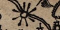
Beside the river SE of St Mary Bourne is a circle with rays which is a watermill.

There is a post mill drawn on the hill NW of Chalton
Although there is no symbol, a mill is labelled at the junction of the Blackwater, Whitewater, etc at the north boundary of the county:-
New MillThis is probbaly the mill of that name on the Blackwater, which is now in Berkshire.
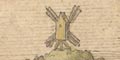
Atop the hill by road from the city is a post mill.
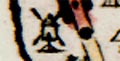
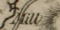
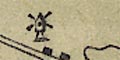
On Portsdown is a post mill, labelled:-
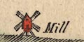
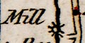
Mill
A post mill is drawn on Portsdown.
Along the shore between Lymington and Milford are small buildings labelled:-
s.h.a note printed below the descriptions of tides tells us:-
N.B. the Letters s.h. where ever they occur stand for Salt Houses.There are numerous windmills, drawn as post mills, with the salterns. On Portsea Island, north east coast, are:-
Salt Pans
On some rivers there is a circle with rays, indicating a water mill, labelled eg:-
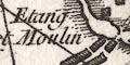
Etang et Moulinmill pond and mill at Beaulieu.
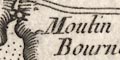
Moulin de Bourneon the River Ems. Note that Thorney Island is shown as an island, which it isn't.
North of Bitterne is:-
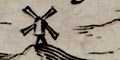
Moulin a PapierAt Compton, West Sussex, there is a windmill, a post mill, on a hillock:-
Moulin de Compton
At least one windmill is marked by a post mill symbol, labelled:-
Ropley Mill
Post mills are drawn near Edmundsbury, 74m. from London on the Wells road.
Water mills are shown along the River Test:-
Mill [Romsey]
Kimbridge Mill
Houghton Milland on the River Anton:-
Nours's Mill [Lower Clatford]
Clatford Mill
Rooksbury Mill
Mr Barlow's Mill [S of Andover]
Windmills might be shown by a drawing of a post mill. Some are named, eg:-
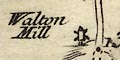
Walton Millin Somerset.
A number of mills are shown on the map
Water mills are shown by a circle with rays, eg:-
(page 103/104 scroll 2 mile 40)
Mill
Paper Millboth near the Hampshire/Surrey border at mile 40-41 from London.
Windmills are shown by a drawing of a post mill, eg at Alton:-
(page 103/104 scroll 2 mile 47)
A number of water mills are shown, usually just by a label, with a symbol. The map would repay a study to locate its record of old mills. For example, up the River Test are:-
Great Bri Mill [N of Romsey]
Mill [top of Lockerley Brook]
Overshot Watering Mill [at Lower Wallop]
Mill [at Stockbridge]I have not noticed any windmills.
A water mill is marked by a rayed circle on a stream on the east side of Hayling Island, labelled:-
Mill
A number of water mills are shown by a rayed circle symbol, for the water wheel, labelled, eg:-
Fleet Mill
Holbury Mill
Mill [at Lower Wallop]
Paper Mill [at Hook]A drawing of a post mill marks the windmill west of Uppr. Hurstbourne.
Hill hachuring is used to suggest the landform immediately behind the coast line. Other relief is not shown, except:-

PORTS DOWNdrawn behind Portsmouth Harbour. A few trees suggest woodland; and a post mill shows a windmill.
Windmills are shown by a post mill symbol at Southsea, on Portsdown with a flag, and at Fareham. Windmills make good landmarks.
Notice:-
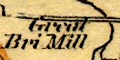
G[ ] Bri Millon the Test, north of Romsey
Water mills are just labelled, perhaps with their specialised purpose, eg:-
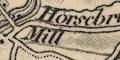
Horsebridge Mill
Fulling Mill [S of Froyle]
Mill [nr Neatham]
Kingsclere Mill
Paper Mill [E of Whitchurch]
Corn Mill [SE of Bishops Waltham]
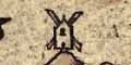
Wood Mill [South Stoneham]Windmills have a drawing of a post mill, even if it is a tower mill as at Bursledon.
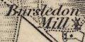
Bursledon Mill
Broad halfpenny Mill
Charlton Wind Milland maybe there is just a clue in a hill name, eg:-
Windmill Hill [NW of Farnborough]
Some water mills are noticed, for example. A block by the Wallop Brook, where it crosses the road from Stockbridge to Salisbury, is labelled:-
Overshot Millwhich is descriptive rather than nominative. And on the Test by Romsey is:-
Great Bri Mill
Water mills are marked by a neat rayed circle across or by a stream, labelled, eg:-
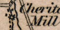
Cheriton Mill
Yateley Mill
Paper Mill [SW of Whitchurch]
Silk Mills [in Andover]Windmills are marked by a post mill symbol, whether they are a post mill or a tower mill, labelled as:-
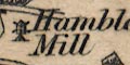
Hambledon Mill
Kimpton Mill
Ibthorp Mill
North of East Woodhay is:-
Ball Mill
On the Test south west of Whitchurch is:-
Mill
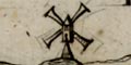
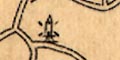
Windmills, drawn by a drawing of a tower mill or post, are useful sea marks. Several are shown, some are labelled, for example:-
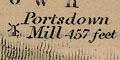
Portsdown Mill 457 feet
Dock Mill
Mill [near Lumps Fort]
Unlabelled, W of Forton Lake.
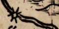
A spiked wheel symbol on the River Meon marks:-
Funtly MillNorth of Bentworth there is a post mill symbol:-
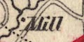
A block by a river might mark a water mill, labelled:-
Millfor instance, several around Romsey. The mill might be named, eg:-
Lockerly Mill
Holbury Millfurther up the Test. There do not seem to be mill symbols. On a hill, nowhere near a stream (not a marked stream), is:-
Sheer Hill Millon the south end of Waltham Chase, which might be a windmill? At Bursledon is:-
Burslean Millwhich is a windmill.
A mill might be noticed, eg:-
Riseley Mill [N of Heckfield]
Mill [E of Petersfield]
The mill is not drawn, but
WINDMILL HILL
is labelled by Chalton.
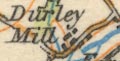
Durley Milla water mill on the River Meon.
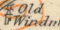
Old Windmillthis is Bursledon Windmill, which is a tower mill; the symbol is a conventional symbol for a windmill, a postmill.
Ellis, C M: 1968: Gazetteer of the Water, Wind and Tide Mills of Hampshire: ProcHFC: vol.25: pp.119-140
Ellis, Monica (ed): 1978: Water and Wind Mills in Hampshire and the Isle of Wight: (Southampton, Hampshire):: ISBN 0 905280 01 6
Kenyon, J R: 1978: Windmills in Hampshire and the Isle of Wight, a Revised List: ProcHFC: vol.34: pp.53-57
Shaw, A Kebble: 1958: Windmills and Watermills in Hampshire: ProcHFC: vol.21: pp.107-133
Shorter, A H: 1954: Paper Mills in Hampshire: ProcHFC: vol.28: pp.1-11
Triggs, Anthony: 1969: Windmills of Hampshire: Industrial Archaeology: vol.6 no.1: pp.12
